 |
|
|
BiblePlaces Newsletter
Vol 8, #5 -
November
9, 2009
You know that the year is drawing to a close when you see calendars for
2010 on store racks. I just received this morning the
2010 Holy Land Calendar produced by
Lamb and Lion Ministries, which
exclusively features photographs from
BiblePlaces.com. The
calendar notes all the major American holidays, and its inclusion of the
Jewish holy days makes it a great way to keep track of important events
not on many American calendars. You can purchase this beautiful calendar
online, and if you order 10 (for Christmas gifts), they will give
you two for free. by
Lamb and Lion Ministries, which
exclusively features photographs from
BiblePlaces.com. The
calendar notes all the major American holidays, and its inclusion of the
Jewish holy days makes it a great way to keep track of important events
not on many American calendars. You can purchase this beautiful calendar
online, and if you order 10 (for Christmas gifts), they will give
you two for free.The new photo
CD available this month is
Lebanon, Syria, and Jordan, volume 4 of the
The American Colony and Eric Matson Collection,
and the featured photos are of the impressive ruins of Palmyra in Syria,
which are included in this volume. Below I describe some of the
work that went into creating
The American Colony
and Eric Matson Collection. Since that's on the long side, I'll
keep this introduction short.
Todd Bolen
Editor, BiblePlaces.com
New Release:
Lebanon, Syria, and Jordan
Volume 4 of
The American Colony and Eric Matson Collection
The fourth volume in this collection goes into territory that I have
not. One day I hope to travel through Lebanon and Syria, but
creating this collection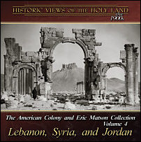 has taught me a lot about these countries which are rich in ancient history and well-preserved ruins.
Since they are not covered in the
Pictorial Library of
Bible Lands, this CD fills in a rather large hole for those
needing images from the entire biblical world.
has taught me a lot about these countries which are rich in ancient history and well-preserved ruins.
Since they are not covered in the
Pictorial Library of
Bible Lands, this CD fills in a rather large hole for those
needing images from the entire biblical world.
The
Lebanon, Syria, and Jordan
CD contains more than 700
selected photographs of sites and scenes in the modern countries of
Lebanon, Syria, and Jordan. The photographs include Ajlun, Aleppo,
Amman, Baalbek, Beirut, Byblos, Cedars of Lebanon, Damascus, Dead Sea
(eastern side), Gerasa, Palmyra, Petra, Sidon, Tripoli, Tyre, and more.
The CD is now on sale for
$20, with free shipping in the U.S.
Creating the
American Colony Collection
Shortly after producing a collection of modern-day photographs in
the
Pictorial Library of Bible Lands (initially released in January 2000), I
began work on a supplementary collection that would peel back the recent
layers of time to reveal the sites of the Holy Land before the changes
brought by modernization. The initial fruit of this work was the
release of 8 volumes of
Historic Views of the Holy Land in November 2004.
About that same time, I learned that the
Library of Congress was digitizing the
G. Eric and
Edith Matson Negatives. Between 1966 and 1981, Eric Matson and his
beneficiary
donated this collection to the Library of Congress. But public access
was limited and costly until 2004, when the first negatives were scanned
and made available online, a huge
job in itself! In browsing through these photographs, I
quickly realized two things. First, these photos would be extremely
useful to teachers and researchers of Palestine and the surrounding
areas. Second, the collection could be greatly improved in a number of
ways.
|
 |
|
The Kazneh (Treasury) at Petra,
damaged stereographic image |
The first step in the process that
culminated in this published collection was downloading all of the online images,
which were made available in three sizes. The medium size was 1024
pixels wide. This is too small if 1) the photo is
damaged;
2) the photo is a
stereographic
image; 3) one wanted to enlarge a particular portion; or 4) one
desired to print the image. The large size was a much higher
resolution (e.g., 5200 x 3600 pixels), but these were in tif format,
which meant the file sizes were so large that they were impractical for
regular use. At 25-70 MB
each in size, these images would take a long time to download and quickly fill up hard
drives. To make this the best
collection possible, I downloaded all of the tif files and converted
them to jpg format, thus retaining the highest resolution, but at a more
manageable file size.
The next step was to identify each image as accurately as
possible. Some of the images would be immediately recognizable to a
recent visitor to Israel, but many are difficult to identify even for
long-time residents. To expedite the process,
Tony Garland, with helpful
advice from staff at the Library of Congress, created a script so that
all of the descriptive information for the photos on the Library of
Congress website could be accessed in a personal database. Seth
Rodriquez, now finishing his PhD dissertation, went through all of the images and wrote a short, descriptive
filename for each one. Andrei Tsvirinko then
copied the names from the database to the jpg image itself. All of the
steps described here are simple enough in themselves, but repeating them
14,000 times requires great perseverance!
The next step in the process was cropping
the photos. Many images are
stereographs, that is, nearly identical side-by-side images which,
when viewed through a stereoscope, appear as a single, three-dimensional
image. Other photographs had tape marks, water damage, or other
blemishes which were best removed by cropping. At a later stage, some
photos were cropped to alter the orientation from vertical to
horizontal, thus creating a more compact view for computer use and
eliminating extensive stretches of sky or earth (see example below).
Other adjustments were required for photos that had been scanned in
mirror-image or were uploaded upside-down.
|
|
|

Sidon castle, stereographic
image, before cropping |
|
|
|
 |
|
Sidon castle, after cropping and
adjustments |
At this point, I began sorting the images into categories. It was necessary to accomplish this step
early in the process because of the numerous duplicates and
near-duplicates in the collection. An important contribution,
therefore, of this edition over the online collection is its selection of the
best images and its logical arrangement of them (either geographically or
topically).
 |
|
 |
|
City of David, 1900-1920,
before and after cropping |
Along the way, numerous corrections and
refinements were made to the descriptions provided by the photographers
of the American Colony and Eric Matson photo services. Some images were
misidentified in the photographers' notes, some were labeled only generally, and some bore names no
longer in use today. In other cases, we were able to correct or improve
upon the supplied dates and identify images that were presented in
mirror image.
One of the most time-consuming tasks of this project
was the removal of blemishes from the images. Some of the negatives are
over 100 years old, and time, transport, and storage have taken their toll
on the material. Since the goal of this project was to provide
"teaching quality" images, larger specks and markings were removed,
though smaller blemishes may still be visible when magnified. In some
cases, the damage was so great that it was impossible to restore the
image. Other adjustments were made to photos for
brightness, contrast, and color.
 |
|
 |
|
Old City of Jerusalem,
before and after restoration (enlarge for detail) |
The creation of PowerPoint presentations
with the images serves several purposes. First, unlike jpg files,
slides in a PowerPoint file can be arranged in sequential order, and
usually I have organized these following a natural tour route. As
many will use these photographs in presentations, having the images
already properly sized and placed in PowerPoint makes it quick and easy
to copy slides from one presentation to another.
Second, explanatory notes or relevant
quotations can be "attached" to the photograph by means of the
"speaker's notes" section in PowerPoint (see
screenshot). Many of the photographs in these volumes are now
accompanied by quotations from 19th century explorers, travelers, and
writers. (The
Jerusalem volume is annotated with original notes by Tom Powers.) Yuliya Molitvenik spent hundreds of hours reading old books
and rare journals in search of choice descriptive statements. These were usually
written before the photos were taken (in the early 20th century), but
they provide additional insight into the sites and scenes depicted in
the photographs. Sometimes the quotations describe details that
precisely match what is in the photo, and other times they may provide a
different "picture." The quotations come from the best available
sources of the day, and are valuable in their own right.
Ultimately, we believe this collection has been improved
through editing, organization, corrections, and the addition of
supplemental quotations. Its superior resolution, format, and
presentation will make it easy to use.
News from the BiblePlaces Blog...
Rare Coin Exhibit in Jerusalem - Two-thousand-year-old coins go
on display this week at the Davidson Center south of the Temple Mount in
Jerusalem...
New Discoveries Related to Temple Mount - A 45-minute interview
with Zachi Zweig suggests that new evidence from the time of Solomon's
Temple may be forthcoming...
Rachel's Tomb, Then and Now - The traditional tomb of Jacob's
favorite wife doesn't look the same today. Other recent subjects
in the "Then and Now" series include the
Herodium and
Pottery Baskets.
New Blog for Tel Burna Excavation - A promising new blog has
been started for a site in the Shephelah that may be identified with
biblical Libnah...
Double-Decker Plaza at Western Wall Planned - If this plan comes
to fruition, you may be able to pray on one level and then walk on the
1st century street directly below...
Jerusalem vs. Pompeii (in Google Earth) - Pompeii clearly wins
if the contest is over high-resolution imagery available in Google
Earth...
Kh. Qeiyafa: Survey vs. Excavation - Does the evidence suggest
that survey data is worse than worthless?...
And more...
Featured BiblePlaces Photos:
Palmyra, Syria
The featured photos of the month are of Palmyra as it looked in the
early 1900s. Palmyra was an oasis in the Syrian desert that
attracted traders and caravans for millennia. Known as Tadmor
in the earliest records, the city reached its height under the
Romans who built most of the standing remains. Some of the
buildings date to the 1st century AD, including the famous Temple of
Bel (Baal). Located in central Syria today, the site continues
to attract and amaze tourists.
These photos are included in the new American Colony and Eric Matson
volume,
Lebanon, Syria, and Jordan.
Each photo below is linked to a higher-resolution version, but we
recommend that you download the
Palmyra PowerPoint presentation
(7 MB), which includes an additional 25 photos (31 total) along with
fascinating quotations from early explorers. You are
welcome to use these images for personal study and teaching.
Commercial use requires separate permission. For more
high-quality, high-resolution photographs and illustrations of biblical
sites, purchase the
Pictorial Library of
Bible Lands or the
Historic Views of
the Holy Land collections. presentation
(7 MB), which includes an additional 25 photos (31 total) along with
fascinating quotations from early explorers. You are
welcome to use these images for personal study and teaching.
Commercial use requires separate permission. For more
high-quality, high-resolution photographs and illustrations of biblical
sites, purchase the
Pictorial Library of
Bible Lands or the
Historic Views of
the Holy Land collections. |
|
Palmyra view from western castle hill
|
|

Click picture for higher-resolution version.
|
|
Charles Addison in 1838: "The
astonishment that takes hold of the mind, at the strange
position of this magnificent city, at one time the capital of
the East, on the edge of the great desert, and surrounded for
several days’ journey on all sides by naked solitary wilds, is
removed by marking well the peculiarity of its geographical
position. The great caravans coming to Europe, laden with the
rich merchandize of India, would naturally come along the
Persian gulph, through the south of Persia, to the Euphrates,
the direct line; their object then would be, to strike across
the great Syrian desert as early as possible, to reach the large
markets and ports of Syria. With more than 600 miles of desert
without water between the mouth of the Euphrates and Syria, they
would naturally be obliged to keep along the banks of that
river, until the extent of desert country became diminished.
They would then find the copious springs of Tadmor [Palmyra] the
nearest and most convenient to make for; and in their direct
route from the north of India, along the Euphrates."
|
|
Monumental Arch |
|

Click picture
for higher-resolution version.
|
|
Charles Addison in 1838: "A little
beyond this is the grand gateway, having a lofty arch in the centre,
and a smaller one on either side leading into the grand avenue of
columns. The scroll work and rich carvings with which it was once
adorned are much mutilated and disfigured on this side, but on the
opposite one looking into the colonnade, the rich ornaments and
decorations are tolerably perfect. It is a noble and elegant
gateway about sixty feet in height. Passing through, we entered the
grand avenue formerly bordered on either hand with an elegant
colonnade, each column having a projection upon which stood a
statue. In its whole length it is almost a mile, and it was
originally bordered by columns the whole way."
|
| Temple of Bel, general view |
|

Click picture
for higher-resolution version.
|
George Post in 1891: "The morning was bright, and our
first thought was naturally the survey of the ruins. Although less
massive than those of Baalbek, the general effect is more striking
and impressive. No street of columns like this exists elsewhere,
not even in Gerash, and the effect when the row was unbroken, and
the monumental building at the western end was perfect, must have
been extremely imposing, from whatever point seen. Not less so was
the grand Temple of the Sun, which for general impression well
rivals that of Baalbek."
|
|
Temple of Bel with peristyle |
|

Click picture
for higher-resolution version.
|
J. L. Porter in 1882: "This is the finest
building in Palmyra, and for extent and beauty it is scarcely surpassed
in the world. A court, two hundred and fifty yards square, was
encompassed by a wall seventy feet high, richly ornamented externally
with pilasters, frieze, and cornice. The entrance was through a portico
of ten columns. Round the whole interior ran a double colonnade,
forming 'porches' or cloisters like those of the temple at Jerusalem.
Each pillar in the cloisters had a pedestal, or bracket, for a statue."
|
|
Temple of Bel, holy of holies |
|

Click picture
for higher-resolution version.
|
George Post in 1891: "The greatest
misfortune of Palmyrene architecture and art was the want of a suitable
stone, in which to express the ideas of their time. The building stone
is a limestone, full of veins and cleavages, so that it was almost
impossible to carve a perfect Corinthian capital out of it, and the
influence of the wind and sun and rain is seen in the defacement and
almost destruction of a large number of elaborate details, which were
undertaken in spite of the discouraging material. The statuary is
chiselled out of a soft argillaceous limestone, easily cut, but as
easily defaced, and incapable, like marble, of taking the finer
expression which Greek and Italian marbles are so well adapted to
receive and retain."
|
|
Tomb interior |
|

Click picture
for higher-resolution version.
|
J. L. Porter in 1882: "In addition to the
tower-tombs there are in the plain to the north and south of the city
immense numbers of subterranean sepulchres. They are not hewn in the
rock, but appear to have been built in natural or artificial cavities,
and then covered over with soil. Those which have been opened were
found to contain loculi, busts, statues, and inscriptions like
the other sepulchres. Numbers of them still remain unexplored, and may
one day afford rich treasures to the antiquary."
|
|
|
FORWARD THIS NEWSLETTER
Please pass this newsletter link on to others.
They can subscribe to this newsletter
here. It is cost-free and spam-free. Email addresses will never be used for any purpose
other than this newsletter. If you have questions about the
subscription process, see
this page.
To subscribe or unsubscribe to this newsletter,
click here.
All contents (c) 2009 Todd Bolen. Text and
photographs may be used for personal and educational use.
Commercial use requires written permission.
|
|


