by Chris McKinny
The tribal town lists and boundary descriptions in the book of Joshua (chapters 13-21) are the most significant textual sources for the geography of the ancient Israel/Judah since they contain the vast majority of place names mentioned in the entire canon. In a soon-to-be submitted (and hopefully accepted) dissertation, I deal with the specific identifications of all of the towns and topographic markers mentioned in Joshua 15 (Judah); 18:12-28 (Benjamin); 19:1-10 (Simeon); and 19:40-46 (Dan) within the framework of a larger argument about the date and purpose of the town lists of Judah (Josh 15:21-62) and Benjamin (Josh 19:21-28). Over the course of the project, I compiled a digital archaeological database/atlas of all of the sites mentioned and discussed in the dissertation (embedded below). This project is called the “Interactive Map: A Historical Geography of the Administrative Divisions of Judah: The Town Lists of Judah and Benjamin in Joshua 15:21-62 and 18:21-28” (click to open in a separate window). The entire map is searchable and each entry (click on each button to expand) includes the biblical place name (in English, Hebrew and Greek), the identified ruin with an archaeological breakdown from the Middle Bronze until the Byzantine period including the Iron II size in dunams, and a bibliography of the archaeological data. The bibliography for the archaeological data contained in the database/atlas can be accessed here.
The tribal town lists and boundary descriptions in the book of Joshua (chapters 13-21) are the most significant textual sources for the geography of the ancient Israel/Judah since they contain the vast majority of place names mentioned in the entire canon. In a soon-to-be submitted (and hopefully accepted) dissertation, I deal with the specific identifications of all of the towns and topographic markers mentioned in Joshua 15 (Judah); 18:12-28 (Benjamin); 19:1-10 (Simeon); and 19:40-46 (Dan) within the framework of a larger argument about the date and purpose of the town lists of Judah (Josh 15:21-62) and Benjamin (Josh 19:21-28). Over the course of the project, I compiled a digital archaeological database/atlas of all of the sites mentioned and discussed in the dissertation (embedded below). This project is called the “Interactive Map: A Historical Geography of the Administrative Divisions of Judah: The Town Lists of Judah and Benjamin in Joshua 15:21-62 and 18:21-28” (click to open in a separate window). The entire map is searchable and each entry (click on each button to expand) includes the biblical place name (in English, Hebrew and Greek), the identified ruin with an archaeological breakdown from the Middle Bronze until the Byzantine period including the Iron II size in dunams, and a bibliography of the archaeological data. The bibliography for the archaeological data contained in the database/atlas can be accessed here.
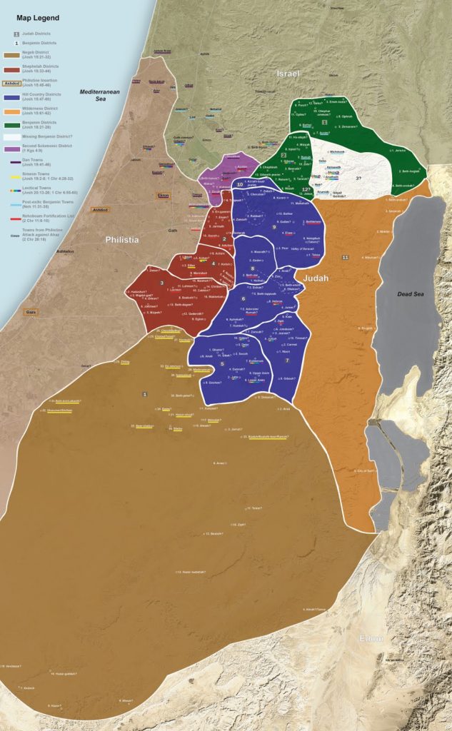
Satellite Bible Atlas users may also be interested in a more traditional map of the town lists/administrative division that I have prepared using the SBA‘s base map. A PDF of the map can be accessed here. I have added a JPEG version of the map below.

6 thoughts on “Interactive Map – The Allotments of the Southern Tribes”
WOW!!!! Just W O W !!!! An amazing amount of work! I wish you well on your examination and ultimately your well deserved Ph. D! I love to go through your map work both digitally and hard copy.
May GOD continue to bless you and your work.
Thankfully,
M. Howard Kehr
Thanks!
I 2nd the Wow! Neat to see where you place "lesser known" towns like Jezreel (of Judah). Of course we get to discuss a few things :), e.g., why you put Geba and Parah way north. Wanna bet "the mountain that overlooks the Valley of Hinnom on the west which is at the north end of the Valley of Rephaim" is Ketef Hinnom, and not the Western Hill of Jerusalem? 🙂
Bill – thanks! you may be right about the western hill versus the slope of the hill connected to meek refaim 🙂 however most of the time the borders run along the slope (compare bethel and Jericho). As for the second part and lest you think that I forgot about jeba' (gebal of Benjamin) – I think (and I follow the suggestions of others) that this geba is geba of Ephraim and in fact there is a jibea with adequate remains which Eusebius also knew about (although incorrectly identifying it with gebim from Isaiah). The rationale for this conclusion is in my dissertation – but it can be boiled down to two main arguments – 1 all of the other known sites in the first Benjamin list (josh 18:21-28) seem to be beyond the tribal border (josh 18:1-12) and 2) seem to be primarily ephramite towns (Ophrah, bethel, zemaraim, Jericho – cf 1 chr 7:28). Parah is only mentioned as a town in this passage and it may or may not be identical as the stream connected with Jeremiah. In general the first Benjamin list is a thorny problem for everyone 🙂
And thanks again for letting me use the base map!
Congratulations, Chris, on a spectacular piece of work! I look forward to having this resource for years to come. Thanks so much–and well done!
My pleasure – btw I it runs on the google maps app if you are in the field