fbpx

The Caspari Center Media Review has two unrelated stories that may be of interest to readers here:

Signposts and directions to the Cenacle [Upper Room on Mount Zion] were defaced by anonymous vandals this past week, adding insult to the injury felt by Christian tourists faced with the piles of refuse and rubbish it contains and making it difficult for them to find their way to the site (Yediot Yerushalayim, March 19).
Other Christian sites are no more attractive to pilgrims, according to a report in Ma’ariv (March 21). According to Yuval Peled, who accompanied a group of Italians who had come to film the Galilee in which Jesus grew up, lived, and taught, “After two or three days of shooting, they abruptly announced that they were leaving. ‘They told us, “You’ve destroyed the story for us, with all the pollution, electricity wires, and infrastructure. This isn’t what we were taught about the place where Jesus grew up,”‘ he recalls. The crew, which had planned to broadcast the film on Italian television – the country considered to be the capital of Christianity – told us that here, in the most authentic place in which the founder of their religion lived, we had destroyed their associations [to it] with pollution and infrastructure. Out of disappointment and despair, they left, and went to shoot the film in Tuscany.”

This sounds like a bit of an overreaction to me.  I don’t like the pollution and wires either, but Galilee is remarkably primitive.  Imagine what the lakeshore would be like if it was in the U.S.

I can’t say I have ever thought of Italy as the “capital of Christianity.” 
Share:

The reconstruction of the Hurva Synagogue is not related to the Bible, but it has our interest because it is such a prominent feature in the Old City of Jerusalem.  Until 1948, there were two major synagogues in the Jewish Quarter, but my guess is that most visitors today are unaware of Tiferet Israel.  The remains of this synagogue lie just north of the main staircase leading down to the Western Wall plaza.  Hurva, on the other hand, is well known because of its central and visible location in the Jewish Quarter plaza.  Many tour guides would stop and explain the significance of the lone arch before allowing their listeners to buy a falafel or to shop in the Cardo.

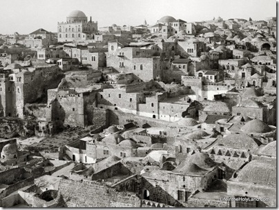
This photo below, part of The American Colony and Eric Matson Collection, is a view of the Jewish Quarter from the Temple Mount taken in the early 1900s.  The large building on the left skyline is the Tiferet Israel Synagogue.  The building with the large dome on the right is the Hurva Synagogue. 

The houses in the foreground stand where today the Western Wall prayer plaza is located.

Jewish Quarter from Temple Mount, mat04722 Jewish Quarter, early 1900s

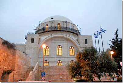
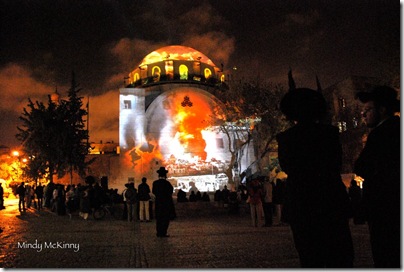
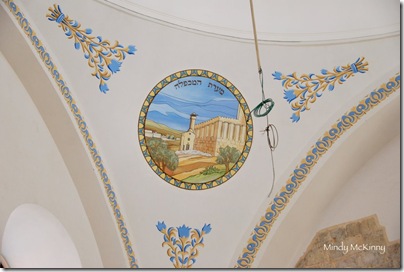
We’ve posted a number of times over the course of the synagogue’s reconstruction, and with its dedication last week we anticipate this will be the final post about it.  We conclude with recent photographs taken by Mindy McKinny. We thank her for permission to share them here.

Hurva synagogue, mm0165

Hurva Synagogue from south

Hurva synagogue light show, mm0244

Hurva Synagogue, sound and light show
Hurva synagogue interior, mm0282 Hurva Synagogue interior

Hurva synagogue interior painting Hebron, mm0274

Hurva Synagogue painting of Tomb of Patriarchs, Hebron
Share:

From the UCLA Newsroom:

If she actually existed, the Queen of Sheba may have been African. Then again, she could have been Arab. While she may have been from Yemen, near today’s city of Ma’rib, she probably was also active in Ethiopia, near the modern city of Aksum. But so far, archaeologists have not found a tomb, palace or temple that can be definitively attributed to the prominent figure from the Hebrew Bible and the Quran. "We know there was an empire that spanned about 1,000 years and had many queens and kings," said Michael Harrower, a postdoctoral fellow at UCLA’s Cotsen Institute of Archaeology. "But we don’t have archaeological evidence for a specific queen that we can say was Sheba. In fact, the biblical character may be a compilation or summary of history of the time." But if archaeology so far has not uncovered the historic Sheba, it has made considerable headway in understanding the 3,000-year-old empire that archaeologists call the Kingdom of Saba — the Arabic name for "Sheba" — whose location and era are consistent with biblical accounts of the queen. On Saturday, April 3, the Cotsen Institute will present a talk at which Harrower and NASA Jet Propulsion Laboratory principal scientist Ronald Blom will discuss these findings. The free event, which is open to the public, begins at 2 p.m. in the Lenart Auditorium of the Fowler Museum at UCLA, on the Westwood campus. Parking is available in Lot 4 for $10. Showcasing the latest advancements in satellite imagery and computer mapping, "The Ancient Universe of the Queen of Sheba" will explore a 200,000-square-mile-area, stretching east from Ethiopia across the Red Sea into Yemen and Oman on the southern Arabian Peninsula. Topics will include the Kingdom of Saba’s impressive irrigation system, its coveted reserves of frankincense and its long-distance trade routes to the Mediterranean.

The news release continues here.  More information is here.

Share:

Here’s something that could easily be overlooked.  In 2004 Fortress published a photo CD by Helmut Koester entitled “Cities of Paul, Images and Interpretations: from the Harvard New Testament and Archaeology Project.”  It was and is very pricey ($250), and because of my teaching interests and my own collection, I purchased but never really used the collection.  But if this is of interest to you, you can now purchase it for less.  Kind of.koester

Logos has a pre-publication special on 20 Fortress volumes on Paul.  One of those “volumes” is this photo collection.  If you use Logos and find any of the other books in the set worthwhile, you can save a few dollars by purchasing now for $230 (retail $776).

If I don’t say, someone is bound to ask me my opinion.  I thought I had written something brief about it previously, but I can’t find it now.  In short, the photos are of high resolution, but most look like old slides that have been scanned.  Diagrams are included, which may be quite useful in teaching.  Note that there are only nine sites included: Athens, Olympia, Corinth, Isthmia, Pergamon, Delphi, Philippi, Ephesus, and Thessalonike.  The notes are extensive and valuable.  I think the $250 price tag is too high.  If you’re a Logos user, you’ll likely find many advantages in this new edition.

There are no reviews of the CD at Amazon.  The work is reviewed positively in the Review of Biblical Literature (pdf).

Share:

The “Northern Philistines” are the featured subject of the current issue of Near Eastern Archaeology. 

The issue is not online, but Aren Maeir, expert on “Southern Philistines,” offers some reflections on the new discoveries.

The Bible and Interpretation has posted Gordon J. Hamilton’s essay, “From the Seal of a Seer to an Inscribed Game Board: A Catalog of Eleven Early Alphabetic Inscriptions Recently Discovered in Egypt and Palestine.”  Among the inscriptions he surveys are the Tel Zayit Stone, Beth-Shemesh Game Board, and Qeiyafa Ostracon.

Aren Maeir explains why he believes Hamilton’s reading of the Safi inscription is not correct.

A new blog that will be of interest to many readers here is Christian World Traveler.

The Book & the Spade 2011 Archaeological Study Tour is now taking sign-ups.  If you’ve been looking for a trip that “does more” and costs less, take a look at the itinerary posted here.

Share:

Earlier this week, there was a story about the discovery of an Umayyad palace that was previously identified as a synagogue.  Early reports contained very few details, but a new story yesterday makes things a bit clearer (HT: Gordon Govier).

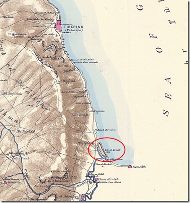
The site is still not named, but a little checking around has revealed that it is Khirbet Beth Yerah (Khirbet el-Kerak) on the southwestern shore of the Sea of Galilee (see map below).  A synagogue was discovered here in the 1950s by P. L. O. Guy and Pesach Bar-Adon.  Current excavations led by Rafi Greenberg of Tel Aviv University now identify the building as an Arabic palace dating to the 7th-8th centuries A.D.  How did they get it so wrong?

The palace was also dismantled down to its foundations after the fall of the dynasty, leaving nothing behind but a foundation and few clues to help date the structure.
Archaeologists at the time also believed, erroneously, that the early Arab caliphates did not carry out many large-scale building projects.
Researchers first began to raise doubts about the origins of the structure in the 1990s, but it wasn’t until 2002 that archaeologist Donald Whitcomb from the University of Chicago first suggested that the site might in fact be the missing Umayyad palace. That identification was confirmed by archaeologists this week.
The identification of the structure as a synagogue was based on the image of a menorah that the early excavators found carved into the top of a pillar base. But the scholars behind the new review of the site realized that the carving was a red herring — that surface would have been covered by a pillar in the original structure, so the carving must have been added later.

The article on Beth Yerah in The New Encyclopedia of Archaeological Excavations in the Holy Land (1993) provides more information on the “synagogue”:

Within the area of the Roman fort, Guy and Bar-Adon uncovered the remains of the foundations of a synagogue (22 by 37 m).  The building was divided by two rows of columns into a nave and two aisles.  There was an apse in the middle of the southern wall, oriented to Jerusalem.  The nave was paved with a colored mosaic, partially preserved, depicting plants, birds, lions, and other motifs.  Carved on the base of a column were a menorah, lulab, ethrog, and incense shovel (1: 258). 

A couple of brief comments.  The apse oriented toward Jerusalem also faces Mecca.  The mosaic’s depictions might surprise some unfamiliar with Arabic tastes in this period, but it closely resembles the Umayyad palace in Jericho (Kh. el-Mafjar).  Apparently the decorated column base threw the original excavators off.  (And you thought archaeologists used pottery for dating.)

You can read more about the Tel Bet Yerah Research and Excavation Project at the official site.

Sheet_06_kerak

From Sheet 6 of the Survey of Western Palestine Maps.  Kh. el-Kerak = Beth Yerah.
Share: