I have lots of high expectations for 2024—especially for family, church, and teaching. But for the readers of this newsletter, my excitement is over the two massive and wonderful volumes we plan to complete and release. It will be by the Lord’s kind grace, to be sure, but we’re on schedule to finish two of the most challenging books to illustrate in the Old Testament.
We’ll kick that off in the next newsletter, but today we have an updated collection of photos of Caesarea Maritima. Caesarea is a familiar site to nearly all tourists visiting Israel, as many tour guides make it their first stop in the land. This updated photo set includes more than 150 photos, both old and new, beginning in the air and then touring the various Herodian highlights, from the theater and palace to the harbor and aqueduct.
Our updated photo sets are always free to those who own the volume—in this case, Samaria and the Center in the Pictorial Library of Bible Lands. This time we want to share it with all of our newsletter subscribers. Below you will find links to download the Caesarea photos and PowerPoint. The PowerPoint has the advantages of (1) being sequentially arranged and (2) including explanatory notes. The jpg images provide higher resolution.
If you like what you see, you may also like the Samaria and the Center volume (1,200 photos for $39) and the Acts volume (4,200 slides for $119). The Samaria volume provides images organized by region and site. The Acts volume is arranged by chapter and verse and includes much more than landscape photos. You are welcome to share this newsletter and this free set of Caesarea photos with anyone. Thank you for your support.
David Ussishkin has made available the complete pdfs of three of his English books published by the Israel Exploration Society. An Academia account is required to download them, but you can sign up for an account for free. The three books that Ussishkin is so generously giving away are:
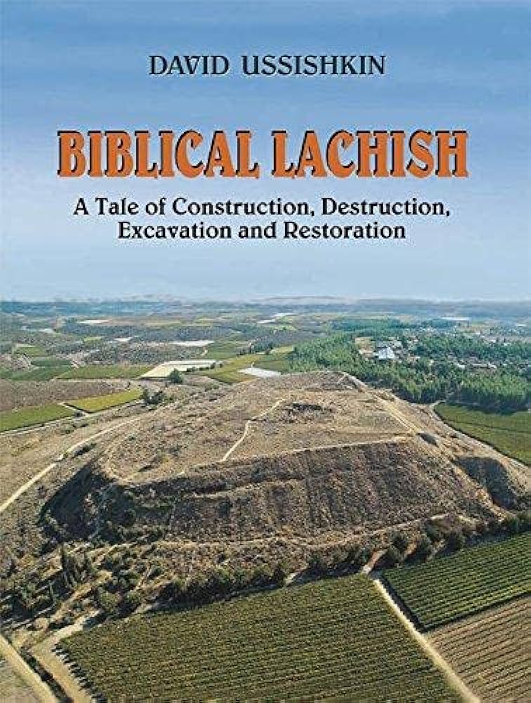
Ussishkin excavated Lachish for 15 years, providing a more complete and accurate understanding of the site than multiple expeditions that worked there in the last century. I really enjoyed this popular-level account of the experience and their discoveries. When time permits, I hope to share some of my favorite quotes and stories on the BiblePlaces Blog.
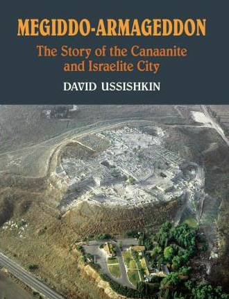
After finishing his work at Lachish, Ussishkin became a co-director of excavations at Megiddo. I purchased this book when it first came out, but I haven’t read it yet. At the cost of free, you don’t have to risk much to pick it up.
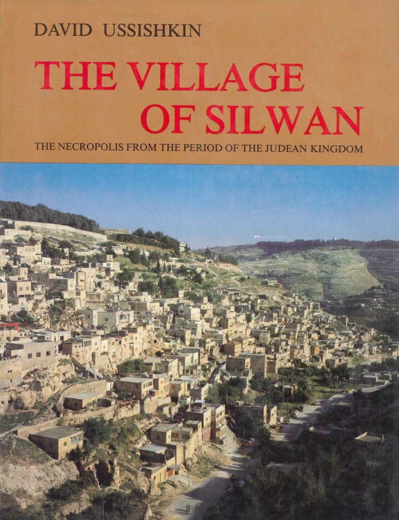
I would guess that this book will be the least popular to readers of this newsletter, but it is not to me. I was nurtured in my archaeological infancy with tales from Ussishkin’s partner in a most remarkable Israeli survey of the (typically hostile) Arab village on the southern end of the Mount of Olives. The Israelite cemetery here includes 50 rock-hewn tombs, including the famous Tomb of Pharaoh’s Daughter and the Tomb of the Royal Steward. And yes, some of these ancient tombs now serve as bedrooms for houses built up against the rock escarpment.
COMPLETE SET (31 volumes): Purchased individually: $1,700; Set Discount: $599
A Photo Every Day
Every weekday I choose an interesting photo from the biblical world and post it on Facebook, Twitter, and Instagram. Follow us to see our latest photos as well as some classics.
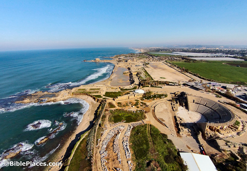
Featured BiblePlaces Photos: Caesarea on the Sea
The featured photos this month are of Caesarea Maritima, the famous port city constructed by King Herod in the decades before the birth of Jesus. Caesarea is best known in the New Testament as the place where the Gentiles first believed in Jesus as the Messiah. It is mentioned several other times in Acts, including as the setting for Herod Agrippa I’s death, Philip and his four daughters’ home, and Paul’s testimony before Felix, Festus, and Agrippa II.
King Herod transformed Caesarea into a great port city after he received the humble village of Strato’s Tower as a gift from Caesar Augustus in 30 BC. Renaming the city after its giver, Herod also named the port Sebastos, the Greek name for Augustus.
Construction began in 22 BC, and Caesarea was dedicated twelve years later. The city had a size of 170 acres and a population in Herod’s day of 100,000, making it even larger than Jerusalem. The city’s value lay primarily in its massive harbor, providing access to Rome and ports to the west, which increased trade. In addition to the usual terms of commerce, ships brought Roman dignitaries and building materials for Herod’s construction projects. Herod adorned the city with a palace, theater, hippodrome, and temple.
A Model of Caesarea
Click photograph for higher-resolution version.
This model located at the harbor lookout fills in some of the details that have not been excavated or preserved. The most significant features are located along the coast, from left to right on the far side of the model: the theater, palace, hippodrome, temple, and harbor. This model depicts walls protecting the city, though archaeologists have debated how early they existed in the city’s history. The prominent hippodrome in the foreground was built in the time of the Emperor Hadrian, and the older hippodrome near the seashore was then converted to an amphitheater.
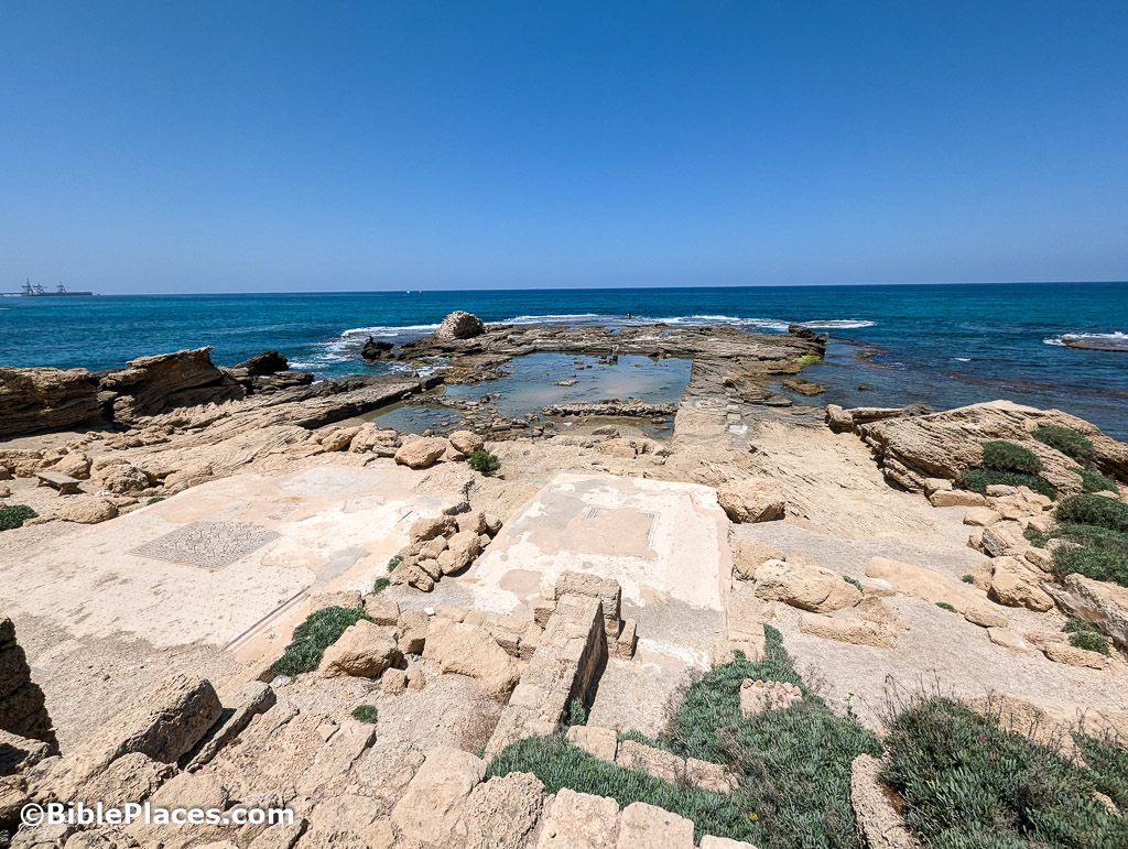
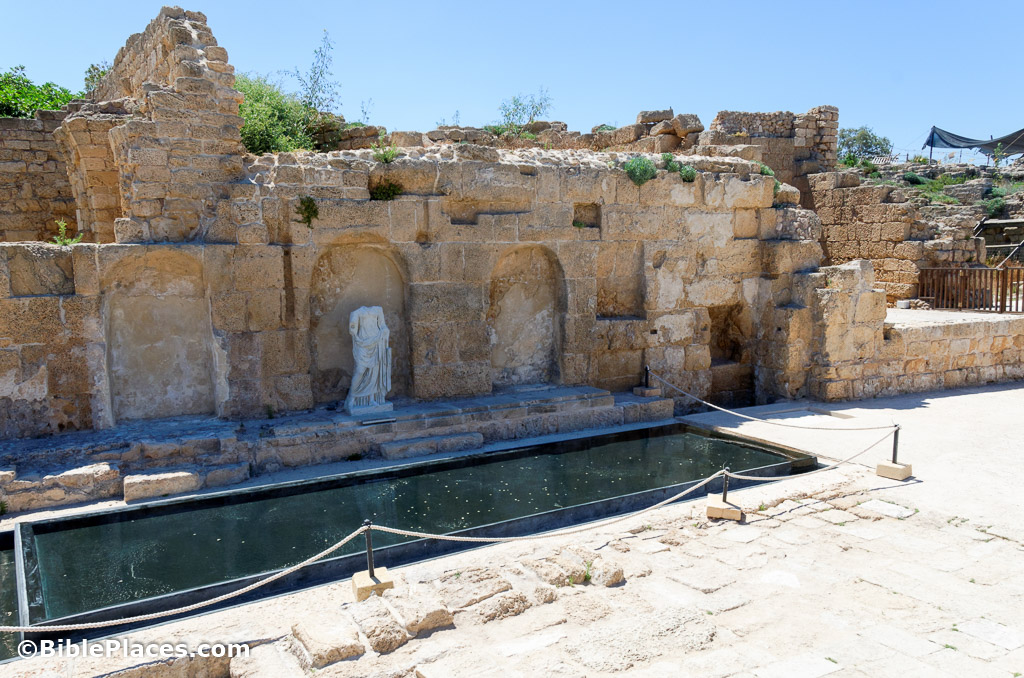
Herod's Swimming Pool in the Sea
Click photograph for higher-resolution version.
Herod’s palaces are renowned throughout Israel, and his palace at Caesarea is another marvel of his masterful engineering. The palace juts out on a promontory into the Mediterranean Sea, and its centerpiece is a pool that is nearly Olympic in size. Water channels from the shore indicate that the pool was filled with fresh water, and a square pedestal in the center probably supported a statue. In the foreground of this photo the beautiful mosaics that decorated an ornate dining room have been uncovered by archaeologists. The walls of the palace were plastered and painted to give the polished effect of finer stone. In addition to the lower terrace shown here, the upper terrace included administrative buildings, a colonnaded courtyard, and gardens.
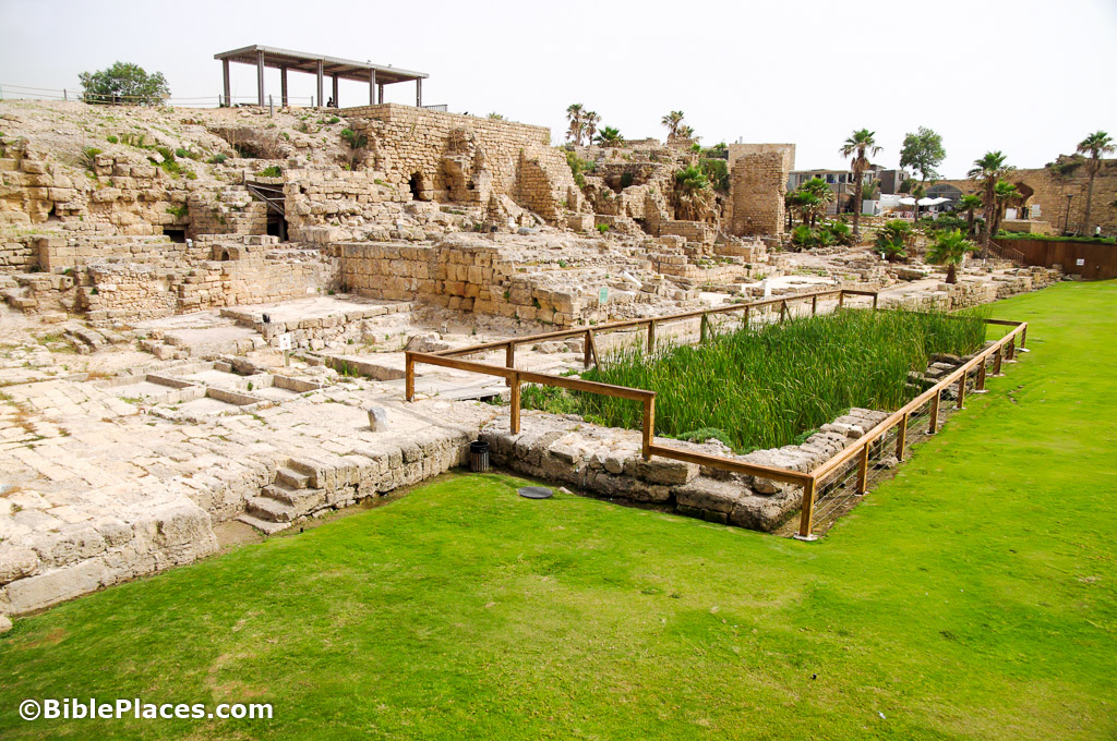
The Eastern Wharf of the Inner Harbor
Click photograph for higher-resolution version.
Herod’s massive harbor not only extended out into the sea far beyond the modern port structures, but it included the area now silted in and covered with grass. Ships docking at the eastern wharf shown here deposited travelers at the base of the temple dedicated by Herod to Emperor Augustus and the goddess Roma. The temple was built above massive warehouses where goods were stored while in transit.
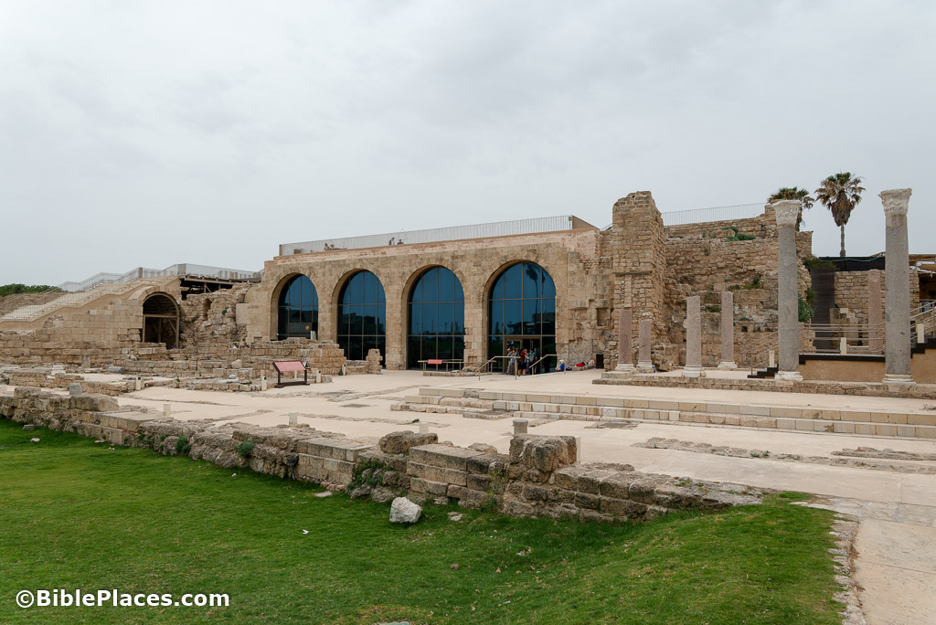
Caesarea's Museum
Click photograph for higher-resolution version.
In recent years archaeologists have restored a portion of those warehouses to create an on-site museum and visitor center. Many original and replica artifacts from the site are displayed here, in addition to artistic reconstructions of the city and an educational movie. The viewing platform with the city model shown in the photo above can be seen atop the expansive windows of the museum.
Caesarea's Ancient Water Fountain
Click photograph for higher-resolution version.
This monumental fountain (nymphaeum) was built in the 1st century AD. The fountain was originally decorated with painted plaster, and its three niches were filled with statues. The structure was incorporated into the northwestern corner of the adjacent temple’s foundation, and it stood at a major junction on the city’s main street, near the harbor, making it a prominent landmark.
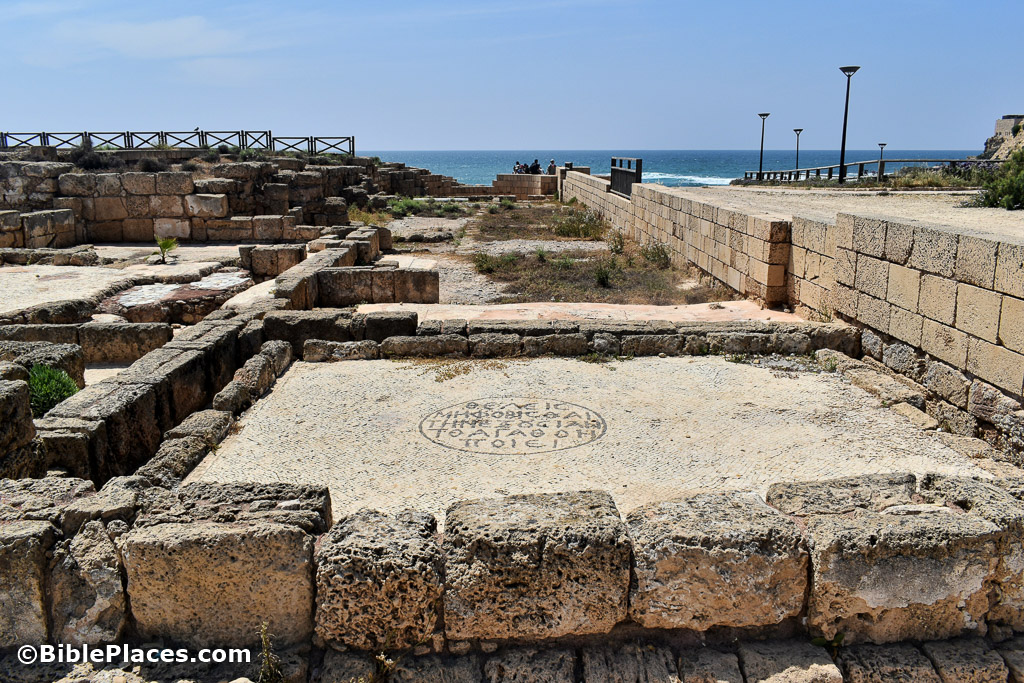
Romans 13 Inscribed in the Tax Office
Click photograph for higher-resolution version.
Those who long for a Christian government in their country today might, if their wish were to come true, see something similar to this mosaic in Caesarea. The Byzantine governor’s officials decided to decorate the tax office with a mosaic inscription with Romans 13:3 written in Greek: “Would you have no fear of authority? Do what is good” (ΘΕΛΕΙΣ ΜΗ ΦΟΒΙΣΘΑΙ ΤΗΝ ΕΞΟΥΣΙΑΝ ΤΟ ΑΓΑΤΗΟΝ ΠΟΙΕΙ). Perhaps the officials thought it would have been overdoing it to add the following line from Romans 13: “If you do wrong, be afraid, for he does not bear the sword for nothing.”
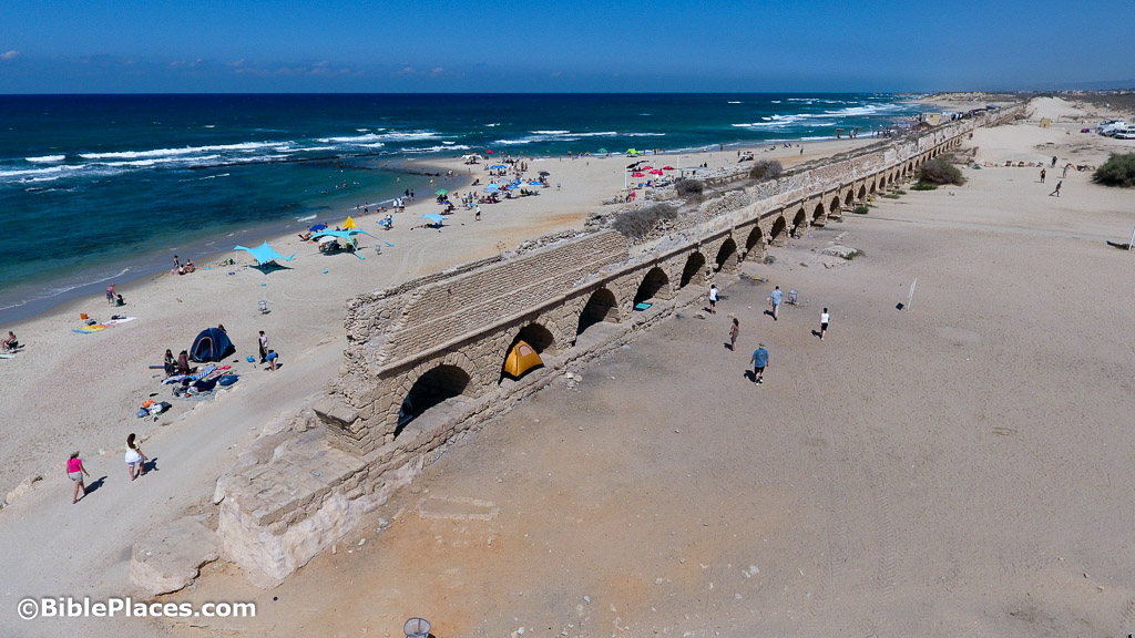
The Aqueduct from Mount Carmel
Click photograph for higher-resolution version.
Though situated on the sea, Caesarea has no natural source of water sufficient for a large city, and so Herod ordered the construction of an aqueduct to bring water from several springs located about seven miles (11 km) away at the foot of Mount Carmel. The arched portion is itself five miles (9 km) long, though the final stretch into the city has been destroyed by the waves pounding the seashore over the centuries. The aqueduct was precisely engineered to have a gradient of 13 inches for each mile (20 cm for each km), and one portion passes through a 1,312 feet (400 m) tunnel hewn through a kurkar ridge. The aqueduct was later doubled in size by Hadrian (circa 130), and the Byzantines built another (low-level) aqueduct further inland.
For more beautiful photos of Israel, purchase the Samaria and the Center volume (1,200 photos for $39). Or buy Acts for only $119 (4,200 slides). Download is immediate, DVD shipping is free, and satisfaction is guaranteed.