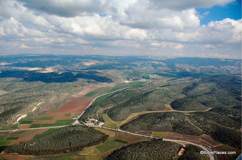
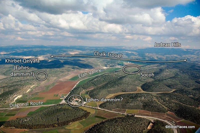
About half a dozen new excavation reports were published yesterday at the IAA’s Hadashot Arkheologiyot, including three from Jerusalem: Mishkenot Sha’ananim – a section of the Low-Level Aqueduct from the Roman-Byzantine period and an earlier unknown period. This aqueduct brought water from Solomon’s Pools to Jerusalem. St. Claire’s Monastery, Talpiot – a section of the High-Level Aqueduct from the 1st-2nd centuries AD. Zedekiah’s Cave – co-sponsored by the [Ron] Wyatt Museum of Tennessee, this 2011 excavation focused on two areas in the lower level of the cave. Remains were found from the Arab and Crusader periods, but the ark of the covenant was not located. All reports include maps, plans, and photographs. Several other discoveries have been mentioned in recent days: Byzantine-era remains of Jewish town found 9 miles (15 km) north of Beersheba will require the re-routing of Israel’s new north-south toolway. Imported pottery from Cyprus discovered at Tel Burna in the Shephelah has been photographed. A figurine was discovered on the surface of Tell es-Safi/Gath by a student. 5386-6 Water channel excavated at St. Claire’s Monastery. Photo by IAA.

Share:

The north of Israel received a surprise August rainfall this week. Haaretz has more about the rabbi who was accused of stealing bones from an archaeological site near Beth Shemesh. Israel will return two sarcophagi lids stolen from Egypt. The BBC describes Lidar archaeology and some debate about its value. Joe Yudin recommends the view from an inactive volcano in the Golan Heights. I think that Wayne Stiles somehow managed to get all of my favorite Masada photos in this article. The ABR bookstore is now offering free shipping on all orders over $35. They offer a number of books under $10. HT: Jack Sasson, Paleojudaica Syrian city northeast of Quneitra from Mount Bental, tb121802203 View towards Damascus from Mount Bental (photo source)

Share:

Two Neolithic figurines were discovered at Moza (biblical Emmaus?) along the Jerusalem-Tel Aviv highway. High-res photos from the IAA are available. Two men were arrested for trying to steal bones from excavations in Beth Shemesh. The Israeli government has appealed the verdict in the case of the Jehoash Inscription, but the rationale for doing so is unclear. Shmuel Browns suggests a 10-day itinerary that will take you to many places you won’t see on a typical Christian tour. Stephen Gabriel Rosenberg provides a review of the archaeological stories in July. Aaron’s tomb near Petra is a “quiet, austere holy site.” There is a lot to see in the Kidron Valley of Jerusalem. Accordance 10 has some nice new features for photographs and maps. Now shipping: Alexander to Constantine: Archaeology of the Land of the Bible, by Eric M. Meyers and Mark A. Chancey. HT: Charles Savelle Neolithic figurine from Moza Neolithic figurine from Moza. Photo by Yael Yolovitch, courtesy of the Israel Antiquities Authority.

Share:

With the discovery of a LMLK seal at Azekah, Omer Sergi of Tel Aviv University gave an impromptu lecture about LMLK seals. Daily updates by volunteers are posted here.

Archaeological sites that currently take years to map will be completed in minutes if tests underway in Peru of a new system being developed at Vanderbilt University go well.”

Egyptian officials are trying to bring back tourists by opening new tombs, including the tomb of Meresankh.

An Israeli journalist has filmed a mass grave near the Golden Gate that he suggests dates to the Roman destruction of Jerusalem.

Like the tower of Pisa, the Colosseum of Rome is leaning.

James Mellaart, excavator of Çatalhüyük, passed away this week.

More than a hundred people gathered at the tomb of Sir Flinders Petrie this week to celebrate the 70th anniversary of his death.

The latest in the wider world of archaeology is reviewed by the ASOR Blog.

Congratulations to Geoff C. and Frank P., winners of Walking in the Dust of Rabbi Jesus.

HT: Jack Sasson, Wayne Stiles, Joseph Lauer

Share:

(Post by Seth M. Rodriquez)

This week’s photo comes from Volume 4 of the revised and expanded edition of the Pictorial Library of Bible Lands and is entitled “Elah Valley Aerial from West” (photo ID #: tb011606772).  One of the improvements in the new edition of the collection is the addition of some aerial photos of the Elah Valley which make it easy to pick out the valley from among the hills of the Shephelah.  In the photo above, the valley can be seen starting at the bottom left corner, moving diagonally up to the center.  (Click on the photo for a higher resolution.)

This photo is extremely useful when discussing the encounter of David and Goliath.  First Samuel 17 sets the stage in the following way:

Now the Philistines gathered their armies for battle. And they were gathered at Socoh, which belongs to Judah, and encamped between Socoh and Azekah, in Ephes-dammim. And Saul and the men of Israel were gathered, and encamped in the Valley of Elah, and drew up in line of battle against the Philistines. And the Philistines stood on the mountain on the one side, and Israel stood on the mountain on the other side, with a valley between them. (1 Sam. 17:1-3, ESV.)

Most of the locations in this passage are visible in this picture.  To assist in identifying them, I’m going to pull from one of the PowerPoint presentations included in the Pictorial Library collection:

In this slide the location of the Elah Valley and Socoh are clearly marked, along with possible locations of Ephes-dammim.  Azekah is not pictured here, but is located just off the photo to the left.  You can easily imagine the Philistine army on one side of the valley and the Israelites on the other, just as it is described in verse 3.

In the background, the Judean Hills are marked which adds to the value of this photo.  When teaching on David and Goliath, I like to point out to my listeners that there was much at stake for David in this battle.  Not only were the Israelite soldiers facing a deadly enemy and not only was the reputation of Israel’s God on the line, but there was another element that we tend not to think about which relates to geography.  If you look at a map of this area you will see that the Elah Valley is an entryway into the Hill Country of Judah, the region where David and his family lived.  Three thousand years after the fact we have the advantage of knowing how it turned out, but if David had lost the battle it is possible that the Philistines would have penetrated into the Judean Hills (as they had when they were encamped at Michmash on the Central Benjamin Plateau).  This would have put David’s family and neighbors at serious risk.  So as David faced Goliath, he was not only fighting for his people and his God … he also was fighting for the safety of his own hometown.

This photo is included in Volume 4 of the Pictorial Library of Bible Lands and can be purchased here.

Share:

Some scholars are suggesting that the depiction on a seal found in the Sorek Valley shows the biblical hero Samson subduing a lion. From Haaretz:

A small stone seal found recently in the excavations of Tel Beit Shemesh could be the first archaeological evidence of the story of the biblical Samson.
The seal, measuring 1.5 centimeters, depicts a large animal next to a human figure. The seal was found in a level of excavation that dates to the 11th century B.C.E. That was prior to the establishment of the Judean kingdom and is considered to be the period of the biblical judges – including Samson. Scholars say the scene shown on the artifact recalls the story in Judges of Samson fighting a lion.
But excavation directors Prof. Shlomo Bunimovitz and Dr. Zvi Lederman of Tel Aviv University say they do not suggest that the human figure on the seal is the biblical Samson. Rather, the geographical proximity to the area where Samson lived, and the time period of the seal, show that a story was being told at the time of a hero who fought a lion, and that the story eventually found its way into the biblical text and onto the seal.

The story continues and explains some of the geographical connections. This discovery reminds me that while Samson’s life largely centers in the Sorek Valley, the most prominent city of that valley is never mentioned in the narrative (Judges 13-16). If the interpretation of this seal is correct, the people of Beth Shemesh remembered their local hero with some pride.

A high-resolution photo of the seal by Raz Lederman is available here.

HT: Joseph Lauer

Share: