fbpx

A study of the temperature of the walls of Tut’s tomb is promising for those looking for a hidden chamber.

Ben Carson believes the pyramids of Egypt were built by Joseph to store grain.

Joseph’s tomb has been restored.

The Hebron archaeological site will not be leased to Jewish settlers.

The PEF has posted a brief video compilation of their recent conference on Jericho.

G. M. Grena reports on a new book dedicated to Robert Deutsch (that includes a chapter by Gabriel
Barkay), his visit to Passages exhibit and lecture, a forthcoming game, and a secret link.

If you don’t know about the Lanier Theological Library, you should read this.

This is your last chance to get in on Logos’s Classic Studies and Atlases on Biblical Geography (7 vols.) at the best pricing ($24-30).

Now free in pdf format: The Petrie Museum of Egyptian Archaeology: Characters and Collections, by Alice Stevenson.

Our most popular photo this week on Facebook and Twitter was this Psalm 23 image from the American Colony Collection.

Shepherd resting with flock at Ein Farah, mat05629
Shepherd tending his flock at a spring in the Judean wilderness
Share:

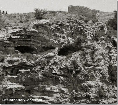
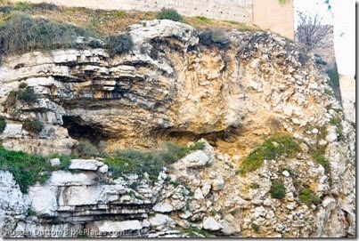
Visitors to the Garden Tomb of Jerusalem are usually shown the “Skull” identified by Charles Gordon as part of the case that this spot may be the authentic site of Jesus’ crucifixion and burial. On February 20 the bridge of the skull’s nose collapsed during a storm. Our friend Austen Dutton visited the site, alerted us to the event, and sent us this photo.

Gordon's Calvary near Garden Tomb, amd022115831

For contrast, here’s a photo taken in 2008.

Gordon's Calvary near Garden Tomb, tb051608027

Visitors to the Garden Tomb are shown the passage that identifies the place of Jesus’ death as “the place of the Skull.”

“Carrying his own cross, he went out to the place of the Skull (which in Aramaic is called Golgotha)” (John 19:17).

It is worth noting that the Gospels never explain why the place was identified by a skull, nor does it say anything about a hill. The name could have come from a geological feature that bore this resemblance. Or it could have been for another reason altogether.

The recent storm and the resultant erosion suggests that the escarpment would have been greatly altered in the years since it was created by quarrying. I would consider it doubtful that anything like the skull-shape visible in recent years was known in the first century. Fortunately for those who prefer the Garden Tomb location, this has never been the primary support for its identification.

Gordon's Calvary showing skull, mat00918
Gordon’s Calvary in 1910s

Our Jerusalem volume in the American Colony and Eric Matson Collection has a section devoted to the Garden Tomb. In notes written by Tom Powers, he provides some of the fascinating background to the identification of the skull.

General Charles Gordon, spending several months in Jerusalem in 1883, became firmly convinced that the hill seen here was the Golgotha of the New Testament. The idea of Skull Hill as Golgotha was not original with him, however, as several earlier travelers and writers had proposed the same identification beginning as early as the 1840s, and Gordon certainly knew of some of these. Among the other proponents of this view was Claude Conder, a Palestine Exploration Fund explorer and surveyor who was sent to Palestine in 1872 and recorded the idea in two of his books, Tent Work in Palestine (1878) and The City of Jerusalem (1909).

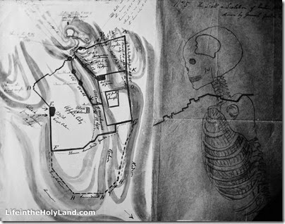
Gordon, however, added his own unique, mystical notions to the theory, however, based in part on both topography and Biblical typology. He believed, for example, that because sacrificial animals were slaughtered in the ancient Jewish temples north of the altar, according to the Mishnah, that Jesus must have been crucified north of the city. Further, Gordon devised a conceptual scheme by which he superimposed a human skeleton on a map of Jerusalem. The skull, not surprisingly, fell on Skull Hill (and he even pinpointed the human figure’s esophagus, a known water channel that entered the city beneath the north wall)!

Plan of Gordon's Idea of Calvary, mat01364
Plan of Gordon’s Idea of Calvary

Gordon added at least one other unusual aspect to the Skull Hill speculations: Being a military man, he consulted a detailed map of the area, the Ordnance Survey Plan of Jerusalem, and was struck by a particular contour line—2549 feet (797 m) above sea level—which, encircling the summit of “Skull Hill,” formed what looked to him like the outline of a human skull. Mention is sometimes made, somewhat derisively, of a revelatory dream or vision that Gordon had, but this seems not to be mentioned in the general’s own writings nor in contemporary accounts.

Gordon expressed his views in a flurry of letters and reports sent to various acquaintances and colleagues, including many to Conrad Schick and many others to Sir John Cowell in England, comptroller to the royal household. General Gordon was a hugely popular figure in his day, the perfect embodiment, one might argue, of military heroics, fervent Christian faith, and Victorian Romanticism, and after his death in Khartoum in 1885 his stature and fame only grew, if that were possible. In any event, there is no denying that the force of his personality provided an important impetus toward the acquisition, development and promotion of the Garden Tomb site, and did much to cement its credentials in the popular imagination.

Bertha Spafford Vester, daughter of American Colony founders Horatio and Anna Spafford, recounts her childhood memories of the famous General Gordon (1882–83):

“Five is not too young for hero worship, and my hero was a frequent visitor to our house, General Charles George ‘Chinese’ Gordon, ‘the fabulous hero of the Sudan’. He was fulfilling a lifelong dream with a year’s furlough in Palestine, studying Biblical history and the antiquities of Jerusalem. This was the only peaceful time the general had known in many years, and it was to be his last. . . . The general lived in a rented house in the village of Ein Karim . . . and General Gordon came often from his village home to Jerusalem riding a white donkey. . . . Whenever General Gordon came to our house a chair was put out for him on our flat roof and he spent hours there, studying his Bible, meditating, planning. It was there that he conceived the idea that the hill opposite the north wall was in reality Golgotha, the ‘Place of the Skull’ . . . He gave Father a map and a sketch that he made, showing the hill as a man’s figure, with the skull as the cornerstone. Part of the scarp of the rock of what is known as Jeremiah’s Grotto made a perfect death’s-head, complete with eye-sockets, crushed nose, and gaping mouth. Ever since then this hill has been known as ‘Gordon’s Calvary,’ although archaeologists are skeptical on the subject . . . Father did not agree with all the general’s visionary ideas, but he liked to talk about these and many other subjects with him, and they were good friends. Mother wanted General Gordon to have peace when he was meditating on the roof, and cautioned me not to disturb him, but I would creep up the roof stairs and crouch behind a chimney; there I would wait. I watched him reading his Bible and lifting his eyes to study the hill, and my vigil was always rewarded, for at last he would call me and take me on his knee and tell me stories.” — Bertha Spafford Vester, Our Jerusalem: An American Family in the Holy City, 1881-1949 (Ariel, 1988), pp. 102-3.

Gordon's Calvary from city wall, mat00919
Gordon’s Calvary from wall of Jerusalem’s Old City (1910s)
Photos from The American Colony and Eric Matson Collection
Share:

Accordance Bible Software has some terrific resources related to archaeology on sale this week. If you haven’t already added these to your collection, this is a great opportunity to do so. I’m particularly fond of these first two photo sets:

Historic Views of the Holy Land: Bible Places—American Colony Collection – more than 4,000 spectacular photos, many of scenes you’ll never seen again. The sale has reduced the price from $149 to $99.90.

Historic Views of the Holy Land: Bible Places—Views That Have Vanished – another collection that is close to my heart. Nearly every day I come across these images as I browse through my broader collection searching and I just love these early color photographs taken by the wonderful David Bivin. Now reduced to $26.90!

The sale includes some other outstanding resources, including (1) Archaeological Study Bible Notes – I took many of these photographs and wrote some of the articles; (2) Biblical Archaeology Review Archive – hundreds of issues of the best archaeology magazine instantly searchable; and (3) the one and only The Sacred Bridge, 2nd edition, for only $109.

These resources will pay you back in deeper knowledge and valuable illustrations many, many times over for years to come. And the search capabilities of Accordance makes it so much easier to find what you are looking for. All of the details are here. The sale ends on the 15th.

Share:

If you haven’t been on a tour of Tiberias in the last decade, you have a lot to catch up on with the work of various excavation projects. Shmuel Browns has a well-illustrated summary of some of the important discoveries, including:

  • The decorative gate of Herod Antipas
  • The main street of the city in use for 700 years
  • The Roman theater built by Herod Antipas
  • A Roman temple (Hadrianeum)
  • A Byzantine monastery and church

His post also includes a number of interesting historical details about the city.

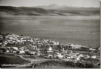
For some interesting descriptions and illustrations of Tiberias in the 19th century, check out Life in the Holy Land.

Mount Hermon from Tiberias, mat08928
Tiberias, the Sea of Galilee, and Mount Hermon
Photo from Northern Palestine
Share:

From the Associated Press:

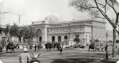
Egypt unveiled Friday a multimillion dollar renovation project for Cairo’s famed Egyptian Museum, including plans to demolish a scorched building that stands between it and the Nile, in a bid to draw tourists back and restore a sense of normalcy after more than two years of unrest. Organizers said they want to return the dusty 111-year-old museum to its former glory by painting the walls and covering the floors in their original colors and patterns. The lighting and security systems also will be upgraded to meet international standards, Minister of Antiquities Mohammed Ibrahim said, announcing the plan during a news conference in the museum’s leafy courtyard. The displays also will be rearranged, although he did not give details about how. One of the museum’s most famous exhibits, King Tutankhamun’s treasures, will be moved to a new Grand Egyptian museum that is being built near the Giza pyramids. It is scheduled to be completed in 2015. Along with the overall tourist industry, the museum has suffered in large part due to its location near Tahrir Square, the epicenter of protests and frequent clashes since the start of the 2011 revolution that ousted autocrat Hosni Mubarak. Violence spiked again after the July 3 military coup that ousted Islamist President Mohammed Morsi. But the interim government that has assumed power is struggling to regain control of the streets and bring back the visitors who long made Egypt a top tourist spot. Ibrahim said the ministry’s revenues, including the entrance fees from tourist sites, fell from 111 million Egyptian pounds in October 2010 to 7 million Egyptian pounds ($1.14 million) in October 2013. “From Tahrir, on a Friday, we are sending a positive message to the entire world: Egypt is doing well,” Ibrahim said on the anniversary of the museum’s inauguration in 1902.

The full story describes the anticipated cost and the involvement of an international team. HT: Jack Sasson Cairo Museum, exterior, mat01484 Cairo Museum, early 1900s
Photo from The American Colony and Eric Matson Collection
Share:

(Post by Seth M. Rodriquez)

Last week we provided a brief history of the American Colony and G. Eric Matson.  Before we move to the next collection in the Historic Views of the Holy Land series, there is one other story about the American Colony that I have to share.

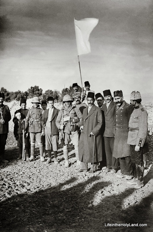
Due to their reputation for organizing charitable work, their connections with the local authorities, and their location within the city of Jerusalem, the American Colony was able to play a role in some of the major historical events of their day.  Last week I mentioned that they were involved in the visit of Kaiser Wilhelm.  Another example is the following story about the day that the mayor of Jerusalem surrendered to the British in 1917:

The final approach of the British forces to Jerusalem, in December 1917, and the subsequent surrender of the city, involved American Colony personnel in a number of curious and fascinating ways. For one, it gave rise to perhaps the most memorable of all American Colony photographs, that of the “first” surrender—by some counts there were as many as five!—of the city of Jerusalem in World War I. By the morning of December 9th Turkish army units had completely withdrawn from Jerusalem and the Turkish governor, Izzat Pasha, fleeing shortly before dawn (in a horse-drawn carriage borrowed from the Colony!), left in the hands of the mayor a letter of formal surrender, including an order that not a shot was to be fired in the city‘s defense. Thus, that Sunday morning the city‘s Arab mayor, Hassain Effendi al-Husseini, armed with the Pasha‘s letter of capitulation, set out to turn the city over to the British. On his way he first stopped to inform his close neighbors at the American Colony, where he had once been a student and was still a frequent visitor. Stopping first at the Big House he encountered Lewis and Edith Larsson, then proceeded to the nearby Vester house where his good friend Anna Spafford was then in residence. In the meantime, Larsson grabbed his camera, his three-year-old son, and a young assistant and hurried to join the mayor‘s growing group in Jaffa Road. In the process, someone from the American Colony—accounts differ as to who—fashioned the requisite white flag of surrender: a bed-sheet from one of the Colony-run hospitals nailed to a broomstick.

Near the village of Lifta on the western fringes of Jerusalem, the party encountered the British forward units, and the mayor tried to “surrender” to two sergeants on sentry duty. While they were waiting for higher-ranking officers to arrive, Larsson immortalized the moment with his camera, a scene showing the mayor, his entourage of municipal officers and Turkish policemen, Sergeants Hurcomb and Sedgewick of the Londoners, and the white bed-sheet flag—the famous image of the “first” surrender of Jerusalem. In the ensuing few hours, al-Husseini also “surrendered” to two artillery officers; to their commander, a Lieutenant Colonel Bailey; and then to Brigadier General C. F. Watson. Some of the local leaders asked Watson, as the ranking officer on the scene, to show himself to the populace in order to help quell some looting that had already broken out. Thus it was that Watson appeared with the mayor at Jaffa Gate and there (according to at least one version) accepted the mayor’s surrender document …. On this occasion, Larsson managed to take more photos, including an “official” shot of Watson opening the letter of surrender, with Mayor Husseini and others standing beside him. This all occurred by about 10 a.m….  

Larsson also managed to save the makeshift truce flag, which eventually found its way to the Imperial War Museum in London.

Quotation from Tom Powers, “Jerusalem’s American Colony and Its Photographic Legacy,” (essay included in The American Colony and Eric Matson Collection, 2009), pp. 35-36, 38. This photo and over 400 others are included in Volume 7 of The American Colony and Eric Matson Collection, and can be purchased here with free shipping.  For more information on the surrender of Jerusalem, see my previous post here.

Share: