fbpx

(Post by Seth M. Rodriquez)

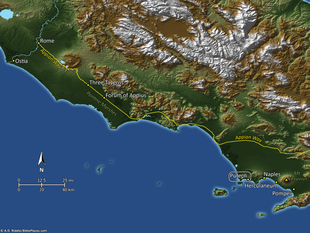
Why did Paul have to land in a harbor about 150 miles from Rome and then walk the rest of the way?
In last week’s post, we discussed the Italian city of Puteoli, which served as Rome’s harbor for many years even though it is a significant distance from the capital. The book of Acts tells us that Paul ended his long and fateful sea voyage in this city:

And after one day a south wind sprang up, and on the second day we came to Puteoli. There we found brothers and were invited to stay with them for seven days. And so we came to Rome. (Acts 28:13b-14)

The reason Paul and his companions had to land at Puteoli was because it was the main harbor of Rome at that time. Although Rome sits on the Tiber River, the mouth of that river had become silted and shallow, so it was not a suitable harbor for the large ships transporting grain and other goods to the capital city. Nevertheless, the city of Ostia sat at the mouth of the Tiber River for many centuries before the time of Paul. The idea of dredging the mouth of the Tiber to make the harbor functional was first thought of at least as far back as the time of Julius Caesar in the mid-first century B.C. But the plan was not executed until much later, under the reign of Claudius in the mid-first century A.D., about the time Paul was traveling to Rome.


As you can see from the map above, the opening of a harbor near the city of Ostia greatly increased the efficiency of transporting goods to Rome by allowing the product to be delivered by boat only a short distance from Rome instead of having to be dragged 150 miles across a significant portion of the Italian peninsula. (Ostia is located in the upper left section of the image and Puteoli is located in the lower right section. Click on the image to enlarge it.) Naturally this was a boost for the city of Ostia, but eventually led to the demise of Puteoli.

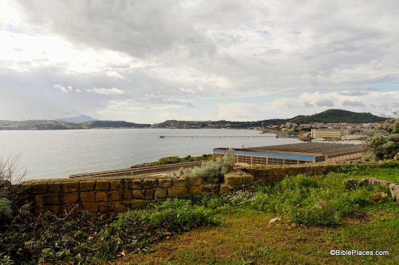
The image above shows the square of the guilds in Ostia with the city’s theater in the background. As a major habor city, Ostia was home to several trade guilds. In this area there were 70 guild offices, many with a mosaic floor identifying which guild used the space. The customs officials also had their offices here. The Harper’s Bible Dictionary lists the following imports that flowed through Ostia: “grain, fruits, fish, meat, hides, oil, wine, minerals, jewelry, lumber, glass, paper, dyes, clothing, spices, ointment, and perfumes.”

The first century city also included a large government building, a temple to Augustus, a gymnasium, a bathhouse with impressive mosaic floors, a public latrine, and a synagogue … all of which are included in Volume 15 of the Pictorial Library of Bible Lands. A Decumanus about 1,200 meters long (3,840 feet) cut through the city. About two thirds of the city has been excavated, and a visit to the site today can give you a good feel for what it was like to live in a Roman city.

Many scholars believe that Paul was eventually released from captivity in Rome and left the capital to continue his mission of planting churches across the western Roman empire. On his journey away from Rome, it is possible that Paul passed through Ostia, however Ostia is not specifically mentioned in the Bible. So although Ostia was a significant city in its heyday, many students of the Bible have never heard of it and it consequently finds itself on our list of “obscure sites in the PLBL.

This concludes our series on “obscure sites in the PLBL.” The last three volumes of the collection focus on trees, plants, and flowers of the Holy Land; cultural images of the Holy Land; and signs of the Holy Land. These are excellent collections and highly recommended, but unfortunately they don’t fit in a series that focuses on obscure places.

On a personal note, I will be taking a break from our “Picture of the Week” series to focus on some other projects for a while. It has been over a year and a half since I started this series. (For those who may be interested, the first post of the series can be found here.) Over that time, I hope I have done justice to the extraordinary qualities of the various collections that have been compiled and edited by Todd Bolen. In a series of blog posts, it is impossible to capture all the fascinating items that are included in the Pictorial Library and Historic Views collections, but hopefully I have given you a taste of what you can find in these works … and whet your appetite for more.

The photograph and map above are included in Volume 15 of the Pictorial Library of Bible Lands, which is available here for $24 (with free shipping).  The excerpt is taken from “Ostia,” in Harper’s Bible Dictionary, edited by Paul J. Achtemeier, Logos Edition (San Francisco: Harper & Row, 1985).  For other posts in our series on “obscure sites in the PLBL,” see here.

Share:

(Post by Seth M. Rodriquez)

Where did Paul’s “fateful trip” finally end?  In a couple of my latest posts, we have been following Paul as he worked his way from Caesarea to Rome as a prisoner. When we last left him, he was on a ship that was intended for Phoenix on the southern coast of Crete, but instead the ship was blown off course and Paul and his companions were shipwrecked on the island of Malta.

Paul and his companions wintered on Malta (see here and here for pictures). Paul healed many people there and most likely spread the gospel in the area as best he could. When winter was over, Paul and his escort of Roman soldiers were finally able to board another ship and travel to Rome. Our “obscure site” this week is the place where they landed for the last time. After making brief stops at Syracuse and Rhegium, Paul finally ended his long sea journey at the harbor city of Puteoli:

After three months we set sail in a ship that had wintered in the island, a ship of Alexandria, with the twin gods as a figurehead. Putting in at Syracuse, we stayed there for three days. And from there we made a circuit and arrived at Rhegium. And after one day a south wind spring up, and on the second day we came to Puteoli. There we found brothers and were invited to stay with them for seven days. And so we came to Rome. (Acts 28:11-14, ESV.)

In the map above, Puteoli is located in the bottom right (click on the image to enlarge). Puteoli had a population of about 100,000 people at this time. Its importance was tied to the fact that the Italian Peninsula does not have very many good harbors. Puteoli was one of the few harbors that were deep enough and protected enough to be of much use to the Romans. And since, for many years, it was the closest good harbor to Rome, it was the main harbor of the capital city and commerce streamed in and out of this port. Much of the wealth of the Roman Empire flowed through this spot.


Of course, when we say it was close to Rome, “close” is a relative term. Puteoli actually sits about 150 miles away. From here, Paul had to travel north on the Via Consularis until he reached the city of Capua, and there stepped onto the Appian Way which finally took him to Rome. To continue Paul’s journey and to see a picture of the Appian Way from the PLBL, see my previous post here.


This photograph and map are available in Volume 14 of the Pictorial Library of Bible Lands, and is available here for $24 (with free shipping). Additional images of Puteoli can be seen on the BiblePlaces website here. For other posts in our series on “obscure sites in the PLBL,” see here.
Share:

(Post by Seth M. Rodriquez)

Continuing our series on “obscure sites” in the PLBL, today we come to a site so obscure that no biblical character ever visited this place, although it is mentioned in the book of Acts.

In an earlier post, we discussed the city of Myra where Paul briefly stopped as he was being transported to Rome. It was there that Paul and his escort of Roman soldiers boarded a grain ship that was traveling to Rome (Acts 27:5-6), but this ship was destined never to arrive. It made it as far as Fair Havens on the southern coast of Crete (Acts 27:8). By this time, the season was changing and winter was coming, but Fair Havens was not a good place to spend the winter because the wind blew right into the harbor. (See here for more information on that topic.) Although Paul warned them not to go any farther, the pilot, the boat owner, and the centurion decided to try to reach another city on the southern coast of Crete: the city of Phoenix (Acts. 27:9-12).

They never made it.

So Phoenix ends up on our list of obscure sites, instead of being trumpeted as the winter quarters of the Apostle Paul. Meanwhile, Paul and his companions were lost at sea and were eventually shipwrecked on a reef off the coast of Malta. On the map below, you can see Fair Havens (where they started) on the southern coast of Crete in the center of the picture, and you can see Phoenix (where they intended to land) to the west  of there (click on the image to enlarge). As you can see from the measurement scale, it was only a distance of about 80 kilometers (50 miles).

Here is the site of Phoenix as it appears today (click on the photo for a higher resolution):

There is one fascinating detail of the description of Phoenix in Acts 27. Luke tells us it is “a harbor of Crete, facing both southwest and northwest” (Acts 27:12). As you can see, the ancient city of Phoenix was built on a promontory, which in modern times is called Cape Mauros. The modern village of Loutro uses a beautiful harbor on the east side of Cape Mauros, located just over the hill in the left side of the picture above. However, in ancient times, the inhabitants of Phoenix used the harbor on the west, and there is still evidence today that the ancient western harbor had two inlets. The one that faces southwest still survives today. The one the faces northwest is harder to see because the waterline is much lower that it was in antiquity and because a rocky reef that extends west from the tip of the cape would have extended farther in the first century than it does now. This reef would have helped to form one side of the northwest inlet.

In the picture above (taken from the PowerPoint presentation included in Volume 13 of the PLBL) the site of Phoenix, the reef, and the southwest and northwest inlets of the harbor are marked. For more information on this topic, you can consult the annotations in that PowerPoint presentation, the information posted here on the BiblePlaces website, or an article by R. M. Ogilvie in the Journal of Theological Studies, vol. 9 (1958), pp. 308-314. The geographical details of Luke’s accounts in the book of Acts have long been praised as extremely accurate. This is just one example among many that Luke knew what he was talking about.

This photo and map are available in Volume 13 of the Pictorial Library of Bible Lands and is available here for $24 (with free shipping). Additional photos and information about Phoenix are available here on the BiblePlaces website, as well as photos and information about these other locations on the island of Crete: Fair Havens, Gortyn, and Knossos.  For other posts in our series on “obscure sites in the PLBL,” see here.

Share:

(Post by Seth M. Rodriquez)


Our “obscure site” for the week is the Roman city of Mitylene, a city that Paul visited during his third missionary journey. (Click on the map above to see its location on an island off the coast of modern Turkey.)  If you don’t remember reading about this city in the New Testament, don’t feel too bad. It is only mentioned in passing and Paul spent less than a day there while he was traveling back to Jerusalem. Perhaps the best way to remember it is to tie it to the story of Eutychus.

Eutychus was the young man (or boy) who fell asleep while listening to Paul preach late into the night. Unfortunately, Eutychus was sitting in a window sill and fell to the ground from the third floor after he dozed off. Luke writes that he was “picked up dead” (Acts 20:9, NASB). But fortunately Paul miraculously brought him back to life (Acts 20:10-12). This happened in Troas on the western shore of Asia Minor (modern Turkey). Paul left Troas the next day, walked twenty miles to the city of Assos, and then boarded a ship where Luke was waiting for him. Luke continues the story by saying:

And when he met us at Assos, we took him on board and came to Mitylene. Sailing from there, we arrived the following day opposite Chios; and the next day we crossed over to Samos; and the day following we came to Miletus. For Paul had decided to sail past Ephesus so that he would not have to spend time in Asia; for he was hurrying to be in Jerusalem, if possible, on the day of Pentecost. (Acts 20:14-16, NASB)

So only a few days after raising Eutychus, we find Paul in Mitylene. This passage makes clear that Paul was quickly moving through this territory and it is not even clear that he set foot on the island of Lesbos where this city is located. Consequently, the city finds itself on our list of “obscure sites in the Pictorial Library of the Holy Land” instead of prominently displayed on the BiblePlaces website along with Samos, Miletus, and Ephesus.

In the image above, you can see the modern city of Mitylene through the window of a medieval castle that sits on the city’s peninsula. This peninsula is actually man-made, similar to the one at Tyre. The castle sits on what was once an island that stood a short distance from the shore. At some point in the city’s history, a causeway was constructed from the shore to the island, and subsequently two harbors were formed (one of which probably sheltered Paul’s ship during the night he was there). The ancient city was inhabited from about 1200 B.C. until A.D. 151 when it was destroyed by an earthquake. In addition to the apostle Paul, the city also played host to Aristotle and Epicurus during its long history.

Now, you probably did not get up this morning and expect to read a blog post about the obscure city of Mitylene or the biblical story of Paul and Eutychus, but this post illustrates an interesting phenomenon … We are curious creatures and images have a way of drawing us into a story. They lead us to want to know more. If you are a teacher, a preacher, a professional in the corporate world … someone who stands up in front of people and delivers information verbally … you should take note of this and use it to your advantage. We live in a visual culture. We also live in a generation that has resources which previous generations could only dream of, if they could imagine them at all. We have at our fingertips photographs and illustrations of places and things all over the world! So the next time you stand up to talk about obscure (or not-so-obscure) topics, start with a photograph. Draw your listeners in by using an image as a springboard to your discussion. Equip yourself with collections such as the Pictorial Library of Bible Lands, Historic Views of the Holy Land, or something similar that exists in your field of expertise. Then use people’s natural curiosity to lead them where you want them to go. Once you have their attention, you can take them anywhere.

This photo is available in Volume 12 of the Pictorial Library of Bible Lands and is available here for $24 (with free shipping). This volume focuses on the Greek Islands, and includes the islands of Samothrace, Samos, Patmos, Cos, Rhodes, and others.

Share:

(Post by Seth M. Rodriquez)

Our “obscure site” for the week was the location of a famous haircut.  Acts 18:18 tells us, “After this, Paul stayed many days longer [in Corinth] and then took leave of the brothers and set sail for Syria, and with him Priscilla and Aquila. At Cenchreae he had cut his hair, for he was under a vow.” (ESV)

The city of Cenchrea (or Cenchreae) was a port city near the Corinthian isthmus in Greece.  Paul was on his second missionary journey and had just completed his 18-month stay in the city of Corinth

When he passed through Cenchrea, he was reaching the end of his journey.  After this, he made a short stop at Ephesus, and then continued on to Caesarea, Jerusalem, and finally Antioch where he started his journey.  Cenchrea is also mentioned in Romans 16:1 where Paul mentions a lady named Phoebe who served the church in that city.

In the photograph below you can see the harbor of Cenchrea. This city served as the eastern port of Corinth, which explains why Paul passed through here on his way back to Jerusalem and Antioch.

John McRay, in his book Archaeology and the New Testament, provides the following information about Cenchrea:

Virtually nothing has been found of the main city of Cenchreae, which lay northwest of the harbor, because during five seasons of excavation from 1963 to 1968 the government restricted work to the harbor except in 1966. … The picturesque harbor thus far excavated, dates to the Roman period. … The Roman harbor originally contained about 1600 feet of shoreline and was 98,000 square feet. In comparison with other Greek and Roman harbors, this one was rather small …. Two large breakwaters, were constructed around a natural bay. The modern shore is about 7.5 feet lower than during New Testament times, due to seismic activity. The harbor’s breakwaters or moles are completely submerged. Pottery and coins give evidence to a city whose commercial life, prosperity, and general status was inextricably tied to Corinth’s. Almost all the coins uncovered have been of Greek mintage or from the eastern Mediterranean, confirming that Cenchrea’s commercial significance was the link it provided between Corinth and the east.

It is unfortunate that further excavations of the site have not been allowed, but that probably explains why we have not yet found the hair that was cut from Paul’s head. 😉

This map and photograph, along with over 800 other images, are available in Volume 11 of the Pictorial Library of Bible Lands, which can be purchased here for $34 (with free shipping).  Another photograph of the harbor at Cenchrea can be seen here on the BiblePlaces website. Ferrell Jenkins has a picture of the harbor available on his blog here. For other posts in our series on “obscure sites in the PLBL,” see here.

The excerpt is taken from John McRay, Archaeology and the New Testament (Grand Rapids: Baker Book House, 1991), pp. 336-337.

Share:

(Post by Seth M. Rodriquez)


Our “obscure site” this week is mentioned only once in the Bible and almost in passing. However, it was the starting point of one of the most famous adventures of the apostle Paul.

In the first century, the city of Myra stood near the southern shores of western Asia Minor. It lies over two miles from the shore so it was closely associated with its port city of Andriace. In fact the harbor city was sometimes just referred to as Myra. The city and its harbor were most likely founded in the fifth century B.C. In the Roman period it was a key location along the trade route used by sailing vessels as they transported grain to Rome. The harbor of Myra was a staging ground where grain from Egypt would be transferred to boats that would carry it on to Rome. In fact, the boat that Paul boarded in Myra may very well have been one of these granary boats (see Acts 27:5-6, 38).

Paul visited Myra while he was a prisoner of the Romans, on his way to a trial before Caesar in Rome. The Wycliffe Historical Geography of Bible Lands, by Charles F. Pfeiffer and Howard F. Vos, provides the following description of what it would have been like to travel by boat from Caesarea to Myra like Paul did:

The westerly winds which favored the voyage from Patara or Myra to Tyre made the return voyage from Tyre to Myra an impossibility. The regular course for ships from Palestine or Phoenicia was northward past the east end of Cyprus and thence along the Asia Minor coast. Then, by means of ocean currents and land winds which blew off the coast, they made their way westward toward Myra. The voyage from Caesarea to Myra might be done in as short a time as ten days, but recorded trips over that route took as long as twenty days. Ships of the Roman grain fleet (on one of which Paul probably sailed) might take the same route if the winds required, but normally they sailed directly from Alexandria to Myra on the Lycian coast …

In the photograph below, you can see the area where the ancient harbor once existed (it has since filled up with silt):

Pfeiffer and Vos provide the following details about Myra and its significance:

In Greek times Patara surpassed Myra, but in Roman times Myra, forty miles eat of Patara, became the chief seaport of Lycia. It grew especially as a result of the Alexandrian grain trade with Italy. Though Myra was located two and one-half miles up the Andracus River from the coast, the same name was often applied to its harbor, Andriaca.

There are several “obscure sites” that Paul passed on his journey to Rome. In future posts we will explore some of them.

This photo and map are available in Volume 10 of the Pictorial Library of Bible Lands and is available here for $34 (with free shipping). This volume also includes the less obscure sites of Ephesus, Smyrna, and Pergamum. For other posts in our series on “obscure sites in the PLBL,” see here.

The excerpts are taken from Charles F. Pfeiffer and Howard F. Vos, Wycliffe Historical Geography of Bible Lands (Chicago: Moody Press, 1967), p. 376.

Share: