(Post by A.D. Riddle)

Several years ago, Chris McKinny wrote a series of posts named “Secret Places.” We resurrect it now to draw your attention to another little-known museum in Jerusalem.

If you have been to Israel a few times, and names like Edward Robinson or Charles Warren are starting to mean something to you, then you may want to add this museum to your next visit.

The museum is located within the compound of Augusta Victoria church/hospital on top of the Mount of Olives. The church’s bell tower is a prominent landmark that can be seen at some distance from several directions. You have certainly seen it, even if you were not aware of what it was.


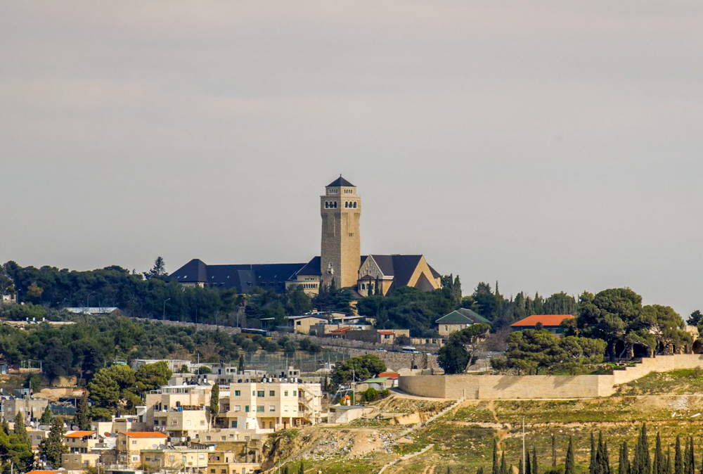
The German Protestant Institute of Archaeology in the Holy Land occupies a house located right behind (east of) the church. As you walk in from the main gate and follow the road to the right, you will see green signs in front of the church that direct you towards the “German Institute of Archaeology.”

The museum is located in the lower story of this house. It highlights the work of Conrad Schick, Gottlieb Schumacher, and especially Gustaf Dalman. On display you will find large models of Jerusalem and the Church of the Holy Sepulcher constructed by Schick, survey instruments used by Schumacher to draw maps and plans, as well as signs with biographical details.

Jerusalem in the Second Temple Period, 1:25,000 scale.
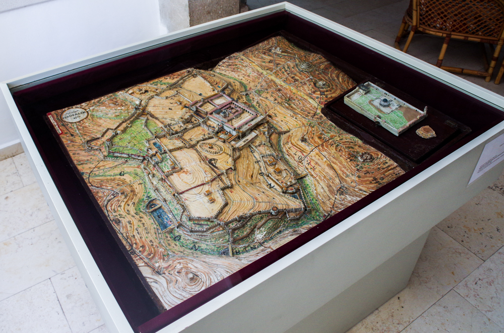
Wood and cardboard model by Conrad Schick, 1867.

Most of the museum, however, is dedicated to the work of Gustaf Dalman. Dalman was the first director of the Institute. His name may be familiar to some readers as the author of Sacred Sites and Ways: Studies in the Topography of the Gospels (1935), one of the few works by Dalman translated into English. He was an expert in the study of, well, pretty much anything related to the Holy Land.

“Dalman’s main aim and starting point was to shed light on the biblical and post-biblical past of Palestine. Instead of only studying texts and relics of the past, and the Bible, he studied the daily activities and customs of the Arab population of Palestine…he combined anthropology, comparative religion, music, and biblical schalarship with geography, geology, botany, astrology, meteorology and zoology into a…new multi-disciplinary field of study…Palestinology”
(Abdulhadi-Sukhtian 2013: vii–viii).

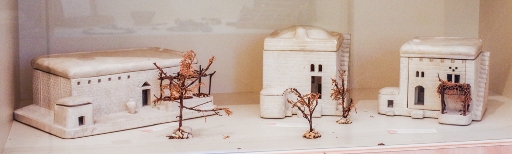
Dalman recorded and collected just about anything you can imagine, and many of these collections are represented in the museum: photographic slides, ancient pottery and coins, herbs, rocks, and limestone models of tombs, presses and Palestinian houses. The models have removable roofs and walls so you can see the interior layout of the structures. It is a little mind-boggling that one man produced all this work.

Limestone models of Palestinian houses.

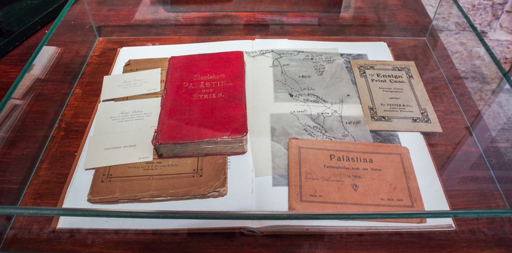
Theologians and pastors would come to the Institute for a three-month course taught by Dalman. A map in the museum shows his itinerary for field trips and a display case contains Dalman’s personal copy of Baedeker Palestine and Syria guidebook.

Gustaf Dalman’s personal materials, including business cards and Baedeker guide.

The museum is not large. You are free to visit, but the Institute requests that you call or email beforehand if you have a group. I would recommend keeping groups very small—ten people would start to feel crowded. A visit will only take about an hour, and most of the labels and signs provide English translations. While you are in the Augusta Victoria compound, the church has a collection of inscribed ossuaries in one of the side rooms. Some of the ossuaries have names like Matthew, Jesus, and Mary. The church also has a life-size replica of the ark of the covenant, and the Bibles of Kaiser Wilhelm II and Empress Augusta Victoria. From the top of the bell tower, on a not-particularly clear day, I was able to make out Baal Hazor, Nebi Samwil, the Dead Sea, and Herodium. It provides a nice view of Jerusalem’s Old City as well.

Contact information for the German Protestant Institute can be found on their website.

Citation
Abdulhadi-Sukhtian, Nadia, trans.
    2013    Work and Customs in Palestine, Vol. 1: The Course of the Year and the Course of the Day. 2 parts. Ramallah: Dar Al Nasher.

Share:

(Post by A.D. Riddle)

Eisenbrauns is about to release, or has just released, two new books. They arrive just in time to add to your July reading list, if you are so inclined.

The first book is a collection of essays published upon the retirement last year of James K. Hoffmeier. Hoffmeier was Professor of Old Testament and Ancient Near Eastern History and Archaeology at Trinity Evangelical Divinity School. “An Excellent Fortress for His Armies, a Refuge for the People”: Egyptological, Archaeological, and Biblical Studies in Honor of James K. Hoffmeier is edited by Richard E. Averbeck and K. Lawson Younger Jr. I believe the photograph on the cover may have been excavated from our own BiblePlaces.com’s archives. It shows the Jebel Barkal stela of Thutmose III. (Daniel Wright had a little fun with the cover design on Facebook.) Below is the table of contents. I see several interesting essays that I look forward to reading.

Chap. 1. The Tests of a Prophet (Richard E. Averbeck)

Chap. 2. Fishing for Fissures: The Literary Unity of the Kadesh Poem of Ramesses II and Its Implications for the Diachronic Study of the Hebrew Bible (Joshua Berman)

Chap. 3. Food for the Forces: An Investigation of Military Subsistence Strategies in New Kingdom Border Regions (Louise Bertini and Salima Ikram)

Chap. 4. Left Behind: New Kingdom Specialists at the End of Egyptian Empire and the Emergence of Israelite Scribalism (Aaron A. Burke)

Chap. 5. The Ficus Judaicus and the New Testament (Thomas W. Davis)

Chap. 6. Gifts of the Nile: Materials That Shaped the Early Egyptian Burial Tradition (Joanna Dębowska- Ludwin and Karolina Rosińska- Balik)

Chap. 7. Computer Analytics in Chronology Testing and Its Implications for the Date of the Exodus (David A. Falk)

Chap. 8. Uniting the World: Achaemenid Empire Lists and the Construction of Royal Ideology (Deirdre N. Fulton and Kaz Hayashi)

Chap. 9. Geophysical Research in Pelusium: On the Benefits of Using the Resistivity Profiling Method (Tomasz Herbich)

Chap. 10. The Genealogies of Genesis 5 and 11 and Comparative Studies: Evidence for a Seam (Richard S. Hess)

Chap. 11. Sety I’s Military Relief at Karnak and the Eastern Gate of Egypt: A Brief Reassessment (Hesham M. Hussein)

Chap. 12. Maʿ at in the Amarna Period: Historiography, Egyptology, and the Reforms of Akhenaten (Mark D. Janzen)

Chap. 13. “I Have Made Every Person Like His Fellow” (Jens Bruun Kofoed)

Chap. 14. The Founding of the Temple in Ancient Egypt: Ritual and Symbolism (Ash Melika)

Chap. 15. Goliath’s Head Wound and the Edwin Smith Papyrus (Edmund S. Meltzer)

Chap. 16. Did the Patriarchs Meet Philistines? (Alan Millard)

Chap. 17. Writing Trauma: Ipuwer and the Curation of Cultural Memory (Ellen Morris)

Chap. 18. Old Kingdom Exotica at Pharaoh’s Court and Beyond: Dwarfs, Pygmies, Primates, Dogs, and Leopards (Gregory Mumford)

Chap. 19. Judges 10:11: A Memory of Merenptah’s Campaign in Transjordan (Steven Ortiz and S. Cameron Coyle)

Chap. 20. Digging for Data: A Practical Critique of Digital Archaeology (Miller C. Prosser)

Chap. 21. Debriefing Enemy Combatants in Ancient Egypt (Donald B. Redford)

Chap. 22. Israelite Origins (Gary A. Rendsburg)

Chap. 23. The Egyptian Background of the Joseph Story: Selected Issues Revisited (Nili Shupak)

Chap. 24. Mighty Bull Appearing in Napata: Memorialization and Adaptation of the Bronze Age into the Iron Age World of the Kushite, Twenty- fifth Dynasty of Egypt (Stuart Tyson Smith)

Chap. 25. Hosea 1–3 as the Key to the Literary Structure and Message of the Book (Eric J. Tully)

Chap. 26. The Egyptian Fortress Commander: A Career Check Based on Selected Middle and New Kingdom Examples (Carola Vogel)

Chap. 27. Mud- bricks as a Dating Tool in Egyptian Archaeology (Kei Yamamoto and Pearce Paul Creasman)

Chap. 28. The God ʾ El of Ramesses II’s Stela from Sheikh Saʿ d (the “Job Stone”) (K. Lawson Younger Jr.)


The second book coming from Eisenbrauns is New Directions in the Study of Ancient Geography, edited by Duane W. Roller. The table of contents did not give me a good indication for what to expect from this volume, but I was helped by the publisher’s description.

This volume brings together five essays that represent the latest directions in the study of geography in classical antiquity. Arranged chronologically, these contributions cover several centuries and cultures, ranging from ancient Mesopotamia to the Roman Empire and deal with topics such as ancient cosmology, literary interpretations of geography, ancient navigation, and geography in the Roman Imperial world.
Beginning in the ancient Near East, Paul T. Keyser’s essay considers how Greek scholars—whose views on the cosmos are still relevant today—were influenced by early Near Eastern beliefs about the universe.

Moving to the Hellenistic period, Duane W. Roller presents and provides commentary on a navigational guide for Ptolemaic seamen written by Ptolemy II’s chief of naval staff, Timosthenes of Rhodes. Georgia L. Irby provides an analysis of a literary map—the Shield of Aeneas from Vergil’s Aeneid—as well as a detailed study of Pomponius Mela and his Chorographia, the earliest surviving Greco-Roman geographical treatise and the only extant independent geographical work in Latin. An essay by Molly Ayn Jones-Lewis completes the volume by describing how Tacitus’s Germania, of the early second century AD, is a work heavily reliant on environmental determinism, an issue that is still relevant today.

Together, these essays demonstrate the great diversity of both ancient geographical writing and modern scholarship on ancient geography. This volume will be greeted with enthusiasm by ancient historians and classical studies scholars, particularly those interested in the cultural and political facets of geography.

I remember the good ol’ days when Eisenbrauns’ vision was to make more affordable for the ANE student these kinds of specialized academic works. It seems we have to kiss those days goodbye. Both of these titles are listed for $99.95. You will find occasional opportunities, however, where the prices are discounted. On their Facebook page announcing the Hoffmeier Festschrift, Eisenbrauns invites people to “Sign up to find out when it publishes and receive 40% off!” I am not sure where or how you sign up.

HT: Mike Mason

Share:

(Post by A.D. Riddle)

Ancient Rome was a large and magnificent city, and while there are lots of impressive structures to be seen today, there are many ruins scattered around and under the modern city. The Atlas of Ancient Rome, quite an extraordinary work in its own right, takes up the task of illustrating the ancient city with plans, reconstructions, and other drawings. This two-volume set is a translation of an original Italian work edited by Andrea Carandini.

The first volume contains “Text and Images” and clocks in at 640 pages. The opening chapters include topics such as “The Natural Landscape” and “The Historical Landscape” and “Building Techniques.” These are followed by 14 chapters corresponding to the 14 Regiones of the ancient city. Each chapter covers the diachronic development of the city for that particular zone, so that, for example, you can without great difficulty focus your study specifically on Rome in the Age of Augustus or specifically on Flavian Rome. In volume one, you will also find a couple dozen beautiful and illuminating reconstruction drawings. I try to show off some of these reconstructions in the following video, and you can also view samples at the atlas’s dedicated webpage.

The atlas is not cheap. The publisher’s price is $200, and Amazon lists it for $169. Is it worth it? Volume one is quite impressive, but $169 is a stretch. My initial instinct was to set aside the second volume for later because it contains “Tables and Indexes.” I assumed “Tables and Indexes” would amount to lots of boring text giving statistics and other data. But when I cracked the cover on volume two, I realized that boy, had I got it wrong. Of the 464 pages, only about 45 page are black-and-white text. It turns out volume two is page after page after page of remarkable full-color plans, diagrams, and maps. Below is a short video in which I flip through some pages to give an idea of the content. You really have to hold it in your hands. After this, the price tag started to make more sense.

I am not a scholar of Rome, but I highly suspect that if your interest in the city goes deeper than the surface, then this two-volume set is a must-have. If you do not fit that description, then you will still probably want to encourage your library to get a copy.

Carandini, Andrea, ed.
2017 The Atlas of Ancient Rome. 2 vols. Princeton: Princeton University Press.

Related sites:

YouTube video highlighting Atlas’s features, by Princeton University Press
Princeton University Press’s description of Atlas
Atlas’s dedicated webpage

Share:

(Post by A.D. Riddle)

On my last trip to the Middle East, I was able to spend some time in London at the British Museum. At the bookshop inside the museum, I discovered a guidebook to the museum. It is not new, but it was new to me. The book is entitled Through the British Museum with the Bible, and if you are planning to spend time in the British Museum anytime soon, I highly recommend this guide. The British Museum is awesomely vast, and you could get lost in it for days. This guide (and others like it) will help you get more out of your time there, and make sure you do not miss the important stuff.

Through the British Museum with the Bible is authored by Brian Edwards and Clive Anderson and is already in its 5th edition.

What do I like about this guidebook? First, unlike other Bible guides for the British Museum, this one is actually the correct size for a guidebook. That is to say, it easily fits in a pocket so that you can have it with you while remaining hands-free. It is also written as a guidebook, providing such information as (1) the gallery and display case where an object is located, (2) brief but sufficient descriptions to understand the object and how it connects to the Bible, and (3) a photo of the object which helps in locating it quickly.

Second, Through the British Museum with the Bible covers a larger number of objects than the other two guides by Mitchell and Masters, listed below. This means it should be useful for more than a single day at the museum.

The other two guides mentioned above are:

(1)  T. C. Mitchell’s The Bible in the British Museum: Interpreting the Evidence (2004). This book covers 72 objects in the British Museum. It is slightly heavier with text, and might be better read before and after your visit to the museum. In my opinion, it is too much reading to do while you are actually in the museum.

(2)  Peter Masters’ Heritage of Evidence in the British Museum, 2nd edition (2016). [I am told the 2nd edition reflects changes in gallery and case numbers as the museum has rotated objects, but is essentially the same content as the 1st edition (2004).] This is a very good guidebook as well.

As I was preparing this blog post, I discovered there is a long history of writing books that relate objects in the British Museum to the text of the Bible. Some of these earlier books can be found online for free.

Kitchin, James George.
     1890     The Bible Student in the British Museum: A Descriptive Guide to the                      Principal Antiquities Which Illustrate and Confirm the Sacred                              History. London: Cassell & Co.

Kinns, Samuel.
     1891     Graven in the Rock, or, The Historical Accuracy of the Bible                                  Confirmed by Reference to the Assyrian and Egyptian Monuments                      in the British Museum and Elsewhere. London: Cassell & Co.

Habershon, Ada R.
     1909     The Bible and the British Museum. London: Morgan and Scott.

Jannaway, Frank G.
     1922     The British Museum With Bible In Hand. London: Sampson, Low,                      Marston & Co.

As a final note, Through the British Museum with the Bible is published by DayOne Publications. As I peruse their website, I see a number of other books that might appeal to readers of this blog. Some examples include: Evidence for the Bible, by the same authors Clive Anderson and Brian Edwards; travel guides for Israel, Jordan, Rome, and Egypt; and books on church history. You might find their website worth a visit.

Share:
(Post by A.D. Riddle)


Several years ago, I checked out a book at the library to read to my kids. It turned out to be a delightful story of a young boy who helps his father harvest resin from trees in Arabia. The connection with Jesus’ birth is sort of a surprise twist at the end of the book, so if you read it to your kids, be sure not to give away that this is a Christmas story—they will get it by the time they reach the last page.

The book is entitled, The Third Gift, by Linda Sue Park (Boston: Clarion, 2011). The Third Gift was probably intended for ages 4-10 (best guess with input from my kids), but the beautiful illustrations (by Bagram Ibatoulline) and the Middle Eastern setting made it interesting for me as well, and it gives you a different perspective for thinking about a very familiar account from the book of Matthew. The “Author’s Note” on the last two pages summarizes the history of our modern perceptions about the biblical story, and re-connects the event with its original geographical and cultural setting. Recommended if you have young ones around for the holidays.

p.p1 {margin: 0.0px 0.0px 0.0px 0.0px; font: 11.0px Palatino}

Share:
(Post by A.D. Riddle)

In 2011, Routledge published Wall Maps for the Ancient World, a series of seven maps which were created by the Ancient World Mapping Center (University of North Carolina, Chapel Hill).

According to the center’s blog, the maps have gone out of print and now the rights have reverted back to the Ancient World Mapping Center. Yesterday, they announced they are making digital versions of the maps available to download. Most of the maps will be of interest to Bible students and readers of this blog. The announcement noted additionally that the digital version of map 6 “World of the New Testament” incorporates some minor corrections.

You can read more about the maps and download them here.

[UPDATE: Yesterday, we experienced troubles trying to download the maps. We contacted AWMC and they are working to resolve the issues. In the meantime, AWMC has removed their blog post about release of the maps. You can continue to read the same information on this other page, but to download the maps, you might want to use this temporary link we have created.]

[UPDATE 2: AMWC has reposted their original announcement, but now it includes instructions to email [email protected] and they will send a link to download one or more files.]

The seven maps are:

1.  Egypt and the Near East, 3000 to 1200 BCE. Scale: 1:1,750,000.
2.  Egypt and the Near East, 1200 to 500 BCE. Scale: 1:1,750,000.
3.  Greece and the Aegean in the Fifth Century BCE. Scale: 1:750,000.
4.  Greece and Persia in the Time of Alexander the Great. Scale: 1:4,000,000.
5.  Italy in the Mid-First Century CE. Scale: 1:775,000.
6.  The World of the New Testament and the Journeys of Paul. Scale: 1:1,750,000. Inset “New Testament Palestine” (Scale 1:350,000).
7.  The Roman Empire around 200 CE. Scale: 1:3,000,000.

Share: