There’s a new interactive satellite map available for download. B. G. Galbraith created this using a high-resolution satellite photo of Israel and then identifying major biblical sites. Each site is hyper-linked to a page with photos, descriptions, and relevant Scriptures about it. The program is free and may be downloaded here. This is another great tool to learn about the land and the Bible. 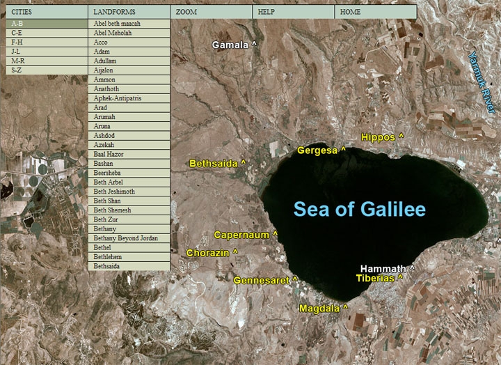
Interactive Satellite Map
- Tagged Resources
Search
About the BiblePlaces Blog
The BiblePlaces Blog provides updates and analysis of the latest in biblical archaeology, history, and geography. Unless otherwise noted, the posts are written by Todd Bolen, PhD, Professor of Biblical Studies at The Master’s University.
Subscribe
Tags
10th Century
American Colony Photos
Analysis
Antiquities Trade
Dead Sea
Dead Sea Scrolls
Discoveries
Egypt
Excavations
Exodus-Conquest
Forgery
Galilee
Greece
Holidays
Israel's Coast
Italy
Jerusalem
Jezreel Valley
Jordan
Jordan Rift
Judah
Lebanon
Lectures
Mediterranean Islands
Mesopotamia
Museums
Negev
New Exhibits
Persia
Philistines
Photo Resources
Picture of the Week
Pseudo-Archaeology
Resources
Sad News
Samaria
Shephelah
Syria
Technology
Temple Mount
Tomb of Jesus
Tourism
Turkey
Weather
Weekend Roundup
Links
Notice
As an Amazon Associate we earn from qualifying purchases. In any case, we will provide honest advice.
3 thoughts on “Interactive Satellite Map”
Thanks for the link, Todd! That’ll be a great tool – especially now that I’m back in the states. I appreciate it.
Nice find. If only it has a scale on each level of zoon to vive an idea of distances.
BTW, have you seen this:
http://www.sundaysoftware.com/HolyLand/
…interesting, but a little over priced.
Thanks for the info Todd! And thanks for donating pictures for it!