(Post by Seth M. Rodriquez)
Having worked through the revised and expanded edition of the Pictorial Library of Bible Lands in this series, we will begin highlighting pictures in a lesser known (but extremely fascinating) series called Historic Views of the Holy Land. This is a sister collection to the PLBL and is featured in a website called LifeInTheHolyLand.com.
Here is a brief description of the series from the website:
The Historic Views of the Holy Land series is an extensive collection of thousands of photographs, drawings, and maps of the biblical lands from the 19th and 20th centuries.
The collection, upon which this website is based, features
- the most detailed and accurate maps of Palestine made before the birth of the state of Israel
- pictures from award-winning photographers who traveled through Egypt, Palestine, Lebanon, Syria, Turkey, and Greece in the 19th century
- photographs and drawings which illustrate biblical scenes, including Psalm 23, the Good Samaritan, and the Woman at the Well.
The first bullet point relates to our “Picture of the Week.” These are the maps created by the Palestine Exploration Fund in the 1870s and published as the Survey of Western Palestine. The maps contain an amazing amount of detail, were the most accurate maps produced in its day, and were created before the massive political and cultural changes were made in the country during the 20th century. Produced at a scale of 1 inch to 1 mile, these maps are a treasure trove for students and scholars interested in biblical geography. A full explanation of the maps and their value can be found here.
Our picture this week focuses on one small area of the maps: the region of Bethel and Ai.
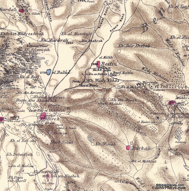
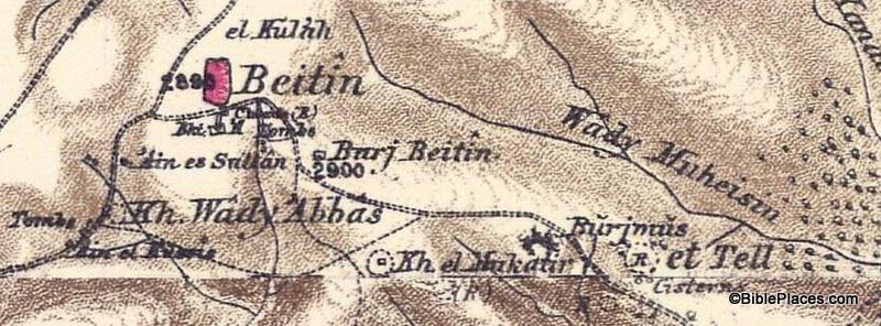
This section shows Beitin as a pink oval in the upper center of the map, which is usually identified as Bethel. It also shows et Tell in the right center and Khirbet el Mukatir to the east of et Tell. The city of Ai (Gen. 12:8; Josh. 7:2) is identified by many scholars as et Tell, but the Associates for Biblical Research have been conducting excavations at Khirbet el Mukatir over the last couple of decades to investigate the possibility of identifying that site as Ai instead. Below is an enlargement of the section of the map that shows Beitin, Kh. el Mukatir, and et Tell so that you can see the relationship between the three sites (click on the picture for a higher resolution):
This is just one example of the many uses of the Survey of Western Palestine Maps. The originals of these maps are not easily accessible in libraries, but the electronic versions are available to all through the Historic Views of the Holy Land collection.
Further information and other images of the Survey of Western Palestine Maps can be found here. You can download the index to the maps for free here, and you can purchase the maps by visiting here. For another example of how these maps can be used, see my post on the Wild Olive Shoot blog here.


