Today’s BiblePlaces Newsletter features a sale on everything we produce and a free collection of photos of Caesarea.
From Heritage Daily:
One of the complex sites contains a distinct, four-sided, truncated, pyramidal shape that is approximately 140 feet in width. This site contains three smaller mounds in a very clear formation, similar to the diagonal alignment of the Giza Plateau pyramids. The second possible site contains four mounds with a larger, triangular-shaped plateau. The two larger mounds at this site are approximately 250 feet in width, with two smaller mounds approximately 100 feet in width. This site complex is arranged in a very clear formation with the large plateau, or butte, nearby in a triangular shape with a width of approximately 600 feet. The sites have been documented and discovered by satellite archaeology researcher Angela Micol of Maiden, North Carolina. Angela has been conducting satellite archaeology research for over ten years, searching for ancient sites from space using Google Earth. Angela is a UNC Charlotte alumnus and has studied archaeology since childhood. Google Earth has allowed her to document many possible archaeological sites, including a potential underwater city off the coast of the Yucatan peninsula that has sparked the interest of scientists, researchers and archaeologists. Angela is also a board member of the APEX Institute, founded by archaeologist William Donato, who is pioneering underwater archaeological research in the Bahamas. Angela has been assisted by Don J. Long, fellow APEX researcher and colleague.
The full story includes photos and a link to more of Micol’s discoveries. HT: Jack Sasson
- Tagged Discoveries, Egypt, Technology
From the Jerusalem Post:
The Jerusalem Biblical Zoo and the Jerusalem Municipality announced on Sunday a NIS 80 million initiative to create Israel’s largest aquarium at the zoo. The aquarium, expected to open in 2015, will hold 2 million cubic meters of seawater in a number of large tanks. The highlight of the exhibit will be an underwater tunnel where visitors can walk underneath the aquarium and see a 180-degree view of the sharks, sea turtles, coral reefs and exotic fishes. The two largest tanks will focus on life in the Red Sea and the Mediterranean, while 30 smaller tanks will feature small habitats…. “Jerusalem will be the first city where there will be both the Red Sea and the Mediterranean Sea, and people won’t be able to say anymore that Jerusalem doesn’t have the sea,” Mayor Nir Barkat said.
The full story is here.
With the discovery of a LMLK seal at Azekah, Omer Sergi of Tel Aviv University gave an impromptu lecture about LMLK seals. Daily updates by volunteers are posted here.
“Archaeological sites that currently take years to map will be completed in minutes if tests underway in Peru of a new system being developed at Vanderbilt University go well.”
Egyptian officials are trying to bring back tourists by opening new tombs, including the tomb of Meresankh.
An Israeli journalist has filmed a mass grave near the Golden Gate that he suggests dates to the Roman destruction of Jerusalem.
Like the tower of Pisa, the Colosseum of Rome is leaning.
James Mellaart, excavator of Çatalhüyük, passed away this week.
More than a hundred people gathered at the tomb of Sir Flinders Petrie this week to celebrate the 70th anniversary of his death.
The latest in the wider world of archaeology is reviewed by the ASOR Blog.
Congratulations to Geoff C. and Frank P., winners of Walking in the Dust of Rabbi Jesus.
HT: Jack Sasson, Wayne Stiles, Joseph Lauer
- Tagged Discoveries, Excavations, Giveaway, Italy, Jerusalem, Shephelah, Turkey, Weekend Roundup
The on-going excavations of Megiddo are the subject of a report by Nir Hasson in Haaretz. The story focuses on the 10th-century debate but mentions a similar text-archaeology problem in the 15th century.
Archaeologist Israel Finkelstein is leading his sweating guests to a corner of Tel Megiddo. He points to a black stain on a rock, which on closer inspection turn out to be charred seeds. “This,” he says, “is the most important find at Tel Megiddo.”
[…]
In one of the four excavation areas on the mound, each marked by its own flag, we come back to the charred crumbs Finkelstein says were the mound’s most important find. Here, under a rainbow flag, we are told they are tiny seeds that Megiddo’s inhabitants collected around 3,000 years ago. They went up in flames when the city was destroyed.
They are important because of their location in relation to finds above and below them. Organic material like this is especially valuable because it can undergo carbon-14 testing, allowing the level where it was found to be dated.
[…]
One of the black layers indicates destruction in the 10th century. Finkelstein’s detractors say David destroyed this city – an idea that Finkelstein rejects because he says the carbon-14 dating rules out the possibility that the city was destroyed suddenly. It shows a gradual process.
The difficulties in reconciling text and archaeology are not limited to the Bible. Those who have great confidence in archaeology and their interpretation of the material remains tend to denigrate textual accounts.
Not far away, under a Jolly Roger, a group is excavating fortifications. Here, the finds also defy an ancient text. But this time it’s not the Bible, it’s the Egyptian record of the conquest of Megiddo by Pharaoh Thutmoses III in the 15th century BCE, describing a seven-month siege.
But the excavators discovered that the city walls at that time were meager. Finkelstein explains the discrepancy as he does with the Bible. The Thutmoses text was written to glorify the pharaoh’s vanquishing of a supposedly mighty city.
This proposal is less satisfying when considered more carefully. According to Thutmoses’ own records, his army surprised the Canaanite forces when they traveled through the Megiddo pass (Nahal Iron). With the Canaanite soldiers positioned near Jokneam and Taanach, Megiddo was an easy target. Yet the Egyptian soldiers pursued plunder and the Canaanites were able to escape into the safety of the city walls. A seven-month siege was required to take what could have been easily captured with some basic army discipline. While Thutmoses III certainly was glorified by his ultimate defeat of the Canaanite coalition, it is not easy to understand why he would have invented such an embarrassing story.
The full story is here. The Hebrew version includes a slideshow with 6 photos of the excavations.
Some day I’ll explain why many scholars reject Finkelstein’s dating of 10th-century remains at Megiddo.
HT: Joseph Lauer
- Tagged 10th Century, Excavations, Jezreel Valley
(Post by Seth M. Rodriquez)
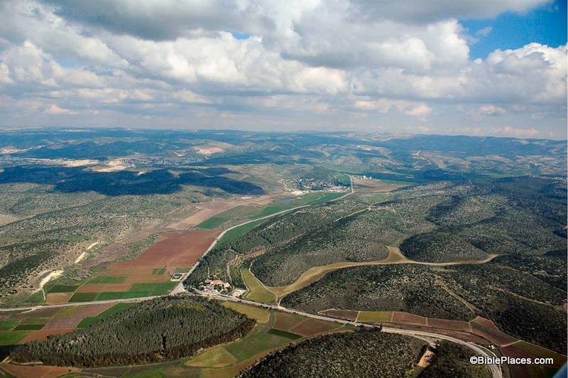
This week’s photo comes from Volume 4 of the revised and expanded edition of the Pictorial Library of Bible Lands and is entitled “Elah Valley Aerial from West” (photo ID #: tb011606772). One of the improvements in the new edition of the collection is the addition of some aerial photos of the Elah Valley which make it easy to pick out the valley from among the hills of the Shephelah. In the photo above, the valley can be seen starting at the bottom left corner, moving diagonally up to the center. (Click on the photo for a higher resolution.)
This photo is extremely useful when discussing the encounter of David and Goliath. First Samuel 17 sets the stage in the following way:
Now the Philistines gathered their armies for battle. And they were gathered at Socoh, which belongs to Judah, and encamped between Socoh and Azekah, in Ephes-dammim. And Saul and the men of Israel were gathered, and encamped in the Valley of Elah, and drew up in line of battle against the Philistines. And the Philistines stood on the mountain on the one side, and Israel stood on the mountain on the other side, with a valley between them. (1 Sam. 17:1-3, ESV.)
Most of the locations in this passage are visible in this picture. To assist in identifying them, I’m going to pull from one of the PowerPoint presentations included in the Pictorial Library collection:
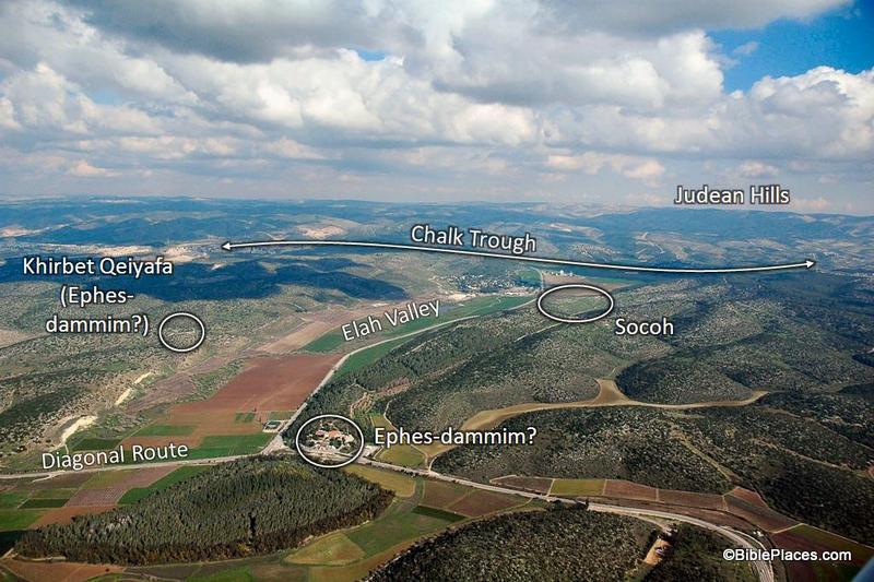
In this slide the location of the Elah Valley and Socoh are clearly marked, along with possible locations of Ephes-dammim. Azekah is not pictured here, but is located just off the photo to the left. You can easily imagine the Philistine army on one side of the valley and the Israelites on the other, just as it is described in verse 3.
In the background, the Judean Hills are marked which adds to the value of this photo. When teaching on David and Goliath, I like to point out to my listeners that there was much at stake for David in this battle. Not only were the Israelite soldiers facing a deadly enemy and not only was the reputation of Israel’s God on the line, but there was another element that we tend not to think about which relates to geography. If you look at a map of this area you will see that the Elah Valley is an entryway into the Hill Country of Judah, the region where David and his family lived. Three thousand years after the fact we have the advantage of knowing how it turned out, but if David had lost the battle it is possible that the Philistines would have penetrated into the Judean Hills (as they had when they were encamped at Michmash on the Central Benjamin Plateau). This would have put David’s family and neighbors at serious risk. So as David faced Goliath, he was not only fighting for his people and his God … he also was fighting for the safety of his own hometown.
This photo is included in Volume 4 of the Pictorial Library of Bible Lands and can be purchased here.
- Tagged Picture of the Week, Shephelah
Search
About the BiblePlaces Blog
The BiblePlaces Blog provides updates and analysis of the latest in biblical archaeology, history, and geography. Unless otherwise noted, the posts are written by Todd Bolen, PhD, Professor of Biblical Studies at The Master’s University.
Subscribe
Tags
10th Century
American Colony Photos
Analysis
Antiquities Trade
Dead Sea
Dead Sea Scrolls
Discoveries
Egypt
Excavations
Forgery
Galilee
Greece
Holidays
Israel's Coast
Italy
Jerusalem
Jezreel Valley
Jordan
Jordan Rift
Judah
Lebanon
Lectures
Mediterranean Islands
Mesopotamia
Museums
Negev
New Exhibits
Persia
Philistines
Photo Resources
Picture of the Week
Pseudo-Archaeology
Resources
Sad News
Samaria
Shephelah
Syria
Technology
Temple Mount
Tomb of Jesus
Tourism
Travels
Turkey
Weather
Weekend Roundup
Links
Notice
As an Amazon Associate we earn from qualifying purchases. In any case, we will provide honest advice.

