fbpx

(Post by Seth M. Rodriquez)

The last few weeks we have been examining photographs from The American Colony and Eric Matson Collection.  The pictures have ranged from Lower Beth Horon to Gerasa, from the damming of the Nile to the flooding of the Jordan, and from the interior of Barclay’s Gate to the Locust Plague of 1915.  We are indebted to the work of the American Colony and Eric Matson for these photographs.  This week we will focus briefly on the American Colony itself.

The American Colony started as an American religious group that migrated to Jerusalem in 1881 under the leadership of Horatio Spafford, author of the well-known hymn “It Is Well with My Soul.”  This group was known for charitable work throughout its existence.  In 1896, a significant number of Swedish immigrants joined the group (again, for religious reasons) and the group was able to develop some projects that provided some consistent income for the community.  The photography department became especially lucrative when the group was granted special permission from the German government to photograph the trip of Kaiser Wilhelm to Jerusalem in 1898.  Due to their coverage of that trip and the use of their photographs in newspapers around the world, the photography department earned recognition worldwide.  In subsequent years, the photographers of the American Colony went on several expeditions to capture pictures of various peoples and places.

For example, the photo below is from an expedition to Egypt, and captures what was surely one of the highlights from that trip: an American Colony photographer is standing near the top of one of the pyramids of Giza readying his camera and tripod.  The photo was taken sometime between 1900 and 1920.

There was a split within the American Colony in 1930, and at that time the photography business was handed over to one of the members of the photography staff: G. Eric Matson. Matson kept the department going until 1934 when he and his wife left the community. Then he started his own business called the Matson Photo Service.  He continued to add new photographs to the thousands of pictures that the American Colony had collected over the years.  Below is a picture of Matson and several others from the American Colony on the day of his wedding in 1924.

In 1946, Matson and his wife moved to America bringing most of the collection with him, and in 1966 he donated the whole collection to the Library of Congress. Finally, in the early years of the 21st century, digital copies of the American Colony and Eric Matson Collection were collected, edited, and organized by a Bible teacher named Todd Bolen, with the help of some faithful friends. 

Bolen’s edition of The American Colony and Eric Matson Collection is available for purchase at LifeintheHolyLand.com.

These photographs, along with over 250 others, are available in Volume 8 of The American Colony and Eric Matson Collection which can be purchased here for $15 with free shipping.  This volume of the collection features various people that lived in the Holy Land during the early 20th century: Arabs, Jews, Christians, Bedouin, and many others.

Share:

(Post by Seth M. Rodriquez)

What is it about old photographs that make them so fascinating? 

I think part of the answer lies in our natural curiosity about the past.  What did things look like back then?  And to a student of archaeology, old photographs of archaeological sites can be especially fascinating because it raises the question: What did things look like when the first archaeologists stepped onto the scene?

Our picture of the week comes from Volume 4 of The American Colony and Eric Matson Collection, which focuses on Lebanon, Syria, and Jordan. In the photo below, you can see the southern theater and the forum at Gerasa (a.k.a., Jerash) in the modern country of Jordan.  Gerasa was one of the cities of the Decapolis, and “the country of the Gerasenes” is mentioned in Mark 5:1, Luke 8:26, and Luke 8:37.

The photo was taken sometime between 1920 and 1933. Another early photograph of the forum can be found here on LifeintheHolyLand.com. By way of contrast, this page on BiblePlaces.com shows you what Gerasa looks like today, after the archaeologists have excavated, cleaned up, and reconstructed these ruins. The differences between then and now are striking.

The American Colony and Eric Matson Collection is a wealth of information and has a variety of uses:

  • For the archaeologist, this collection provides photographs of early digs and of sites as they looked before excavations. For better or worse, this was an age when a lone scholar stood over a team of local workers who moved tons of dirt in a single season (and this practice can be seen in the collection). Yet this was also a period when things were fresh and exciting as archaeologists were digging into sites for the first time.
  • For the preacher and teacher, this collection provides additional material which can be used to transport your listeners back to a culture and landscape similar to biblical times. It also can be used to discuss geography or illustrate particular sites.
  • For the historian, this collection provides windows into this dramatic period of history. This was the period of the late Ottoman Empire and the British Mandate when Jewish immigrants were migrating to Palestine and establishing new settlements. It was also a time when technology was on the rise: electric stations and telephone stations were being built, railroads were being constructed, and automobiles and airplanes were coming onto the scene.
  • For the artist and graphic designer, this collection provides many beautiful, crisp, black & white photos of places in the Holy Land that can be used in a variety of ways.  These photos still capture people’s attention and fire their imaginations.

This photograph and over 700 others are available in Volume 4 of The American Colony and Eric Matson Collection and can be purchased here for $20 (with free shipping).  Historic images of other Roman cities can be seen here, here, and here on LifeintheHolyLand.com.

Share:

(Post by Seth M. Rodriquez)

Joshua 3:15 makes the following comment in passing: “now the Jordan overflows all its banks throughout the time of harvest” (ESV). In the context of this chapter, Israel is about to cross into the Promised Land over a miraculously dry riverbed and this comment is included to give greater significance to the miracle. But before you rush to the Jordan with your camera during the next harvest season to snap a photo of this natural phenomena, let me save you some shekels by telling you that the flooding of the Jordan River is not something that happens today.

According to a 2010 report about the Jordan River (noted previously on this blog here), the Jordan River contains only 3% of the water that it did 100 years ago.  According to that report, the river discharged 1.3 billion cubic meters of water in the 19th and early 20th centuries (but see a more conservative estimate in the quotation below from the Encyclopaedia Judaica).  The report contrasts this with the current discharge of the river which is 20 to 30 million cubic meters.  Or to put it in numerical form:

  • 1,300,000,000 cubic meters per year in the past.
  •     30,000,000 cubic meters per year today.

 So “overflowing all its banks” is not a phrase that is typically used when describing the Jordan River today.

Fortunately, we have photographs from the first half of the 20th century that can help us illustrate this biblical phrase.  Our picture of the week (and a bonus picture) come from Volume 3 of The American Colony and Eric Matson Collection which focuses on Southern Palestine.  To show the contrast in the river’s levels, I have included two photos from that collection.  The first photo is a picture of the newly constructed Allenby Bridge with the Jordan River flowing peacefully about 30 feet below it. 

(As a side note, this is not the Allenby Bridge/King Hussein Bridge used today, but merely a forerunner of the modern bridge.)

The date of the photograph above is around 1920.  The photograph below was taken in February, 1935.  This was an unusually high year for the Jordan River and it “overflowed all its banks,” damaging and destroying surrounding buildings and roads.

If you look closely in the upper right section of the photo you can see the Allenby Bridge with its bottom edge touching the water.  A closer view of the bridge can be seen in another photo from the collection which is posted here.

This flood year is mentioned in passing in the Encyclopaedia Judaica:

The Jordan discharges c. 875 million cu. m. into the Dead Sea a year; its yearly fluctuations are great and are caused mainly by the Yarmuk: in 1933, 287 million cu. m. and in 1935, 1,313 million cu. m.

According to this statistic, the Jordan River discharged 50% more water that year than the yearly average.  There is no way of knowing how much water was discharged during the year that Joshua and the Israelites crossed, but we can be certain that the photograph above is a much better illustration of how it looked than any picture that could be taken today.

Fortunately the future of the Jordan River is looking brighter.  This last summer, this blog noted a report about a plan by Israel to divert some additional water to Jordan River (see post here).  Perhaps future generations will again be able to see the Jordan overflow its banks.

These photographs and over 550 others are available in Volume 3 of The American Colony and Eric Matson Collection and can be purchased here for $20 (with free shipping).  Other historic images of the Jordan River can be seen here and here on LifeintheHolyLand.com, as well as a page devoted to illustrating Joshua and the Israelites “Entering the Promised Land” here

Share:

(Post by Seth M. Rodriquez)

This was a difficult week to come up with a photo to share.  The problem wasn’t due to a lack of good material … the problem was that there were too many good photos available!

This week’s photo comes from Volume 2 of The American Colony and Eric Matson Collection, which focuses on Jerusalem.  These are photographs of Jerusalem taken in the first half of the 20th century before many of the modern developments were built.  So much has changed in the city since that time (both physically and politically) that this volume is a gold mine of material for Jerusalem studies.

Here is a list of some of the photos I could have chosen for this week’s post:

  • The City of David when it was still being used for farmland.
  • A German zeppelin hovering over the Old City.
  • The interior of the Golden Gate on the Temple Mount.
  • The interior of the Double Gate on the Temple Mount.
  • The interior of Solomon’s Stables in the Temple Mount (but see here for a similar photo).
  • The interior of the Hurvah Synagogue before it was destroyed in the War of Independence.
  • The Pool of Hezekiah filled with water instead of trash (but see here for similar images).
  • Sealed entrances to the Church of the Holy Sepulcher.
  • The short-lived and aesthetically questionable clock tower built on top of Jaffa Gate (but see here for a previous post on that subject).
  • Remains of a Crusader-period monastery in the Kidron Valley, a small portion of which was only briefly excavated in 1937 and then buried again.
  • Crowfoot and Fitzgerald’s 1927-28 excavations in the City of David.
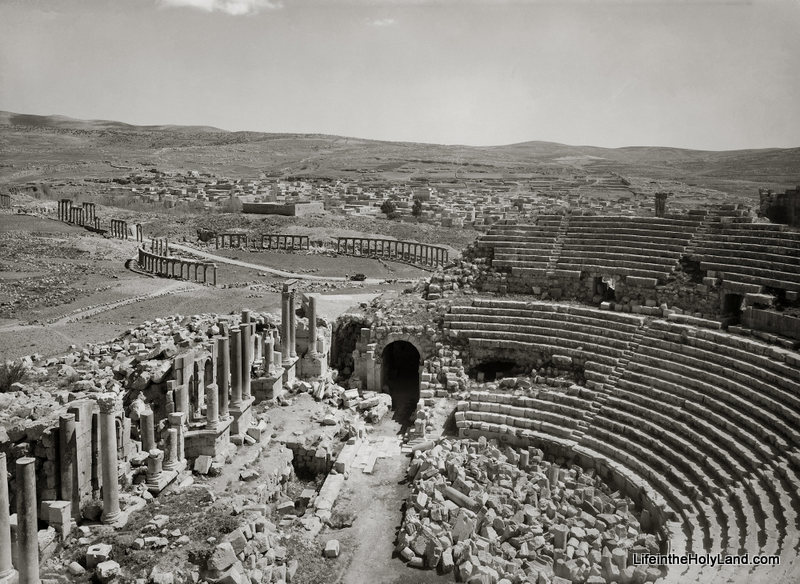
  • A smog-free landscape looking east which includes the Hinnom Valley, Mt. Zion, the Judean Wilderness, the Dead Sea, and the mountains of Moab.
  • The Jewish Quarter and the Western Wall as they looked before the War of Independence (but see here for a similar photo).

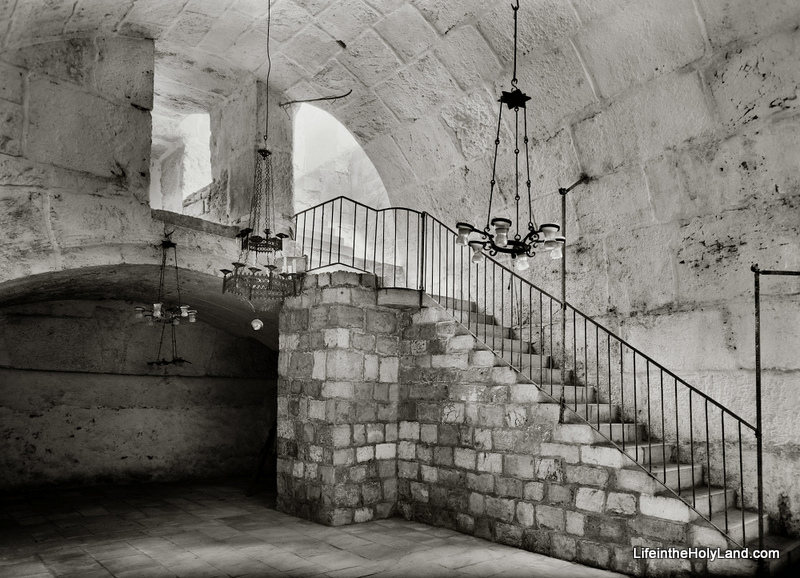
Instead, I will present the following rare photo of the interior of Barclay’s Gate (or at least the top section of the gate) on the western side of the Temple Mount, taken sometime between 1940 and 1946.


Barclay’s Gate was one of the entrances to the Temple Mount during the Second Temple Period (the time of Jesus and the apostles). A modern photo of the outside of Barclay’s Gate, in the women’s area of the Western Wall Plaza, can be seen here.  Only the stone that formed the lintel is visible today from the outside.  In the PowerPoint notes included in the collection, Tom Powers explains what we can see in the photograph above:

This fascinating photograph (looking northwest) shows a room lying beneath the surface of the Temple Mount (to Muslims, the Haram esh-Sharif, or “Noble Sanctuary”). This space was the subject of several descriptions and drawings by 19th century explorers but has rarely been seen by Westerners—or photographed. Much better known, actually, is the opposite side of the thick wall seen here at the end of the vaulted room: it is the massive lintel and blocked opening of an original western entrance of the Herodian Temple Mount, the so-called “Barclay’s Gate” partially visible in the very southern end of today’s Western Wall (women’s prayer area).  

The ancient gate was identified in modern times by James T. Barclay, an American Protestant medical missionary and amateur explorer of Jerusalem’s ancient places. In the course of recounting his identification of the exterior gate elements, Barclay also described the space pictured here: 

“During the period of my admission into the Haram enclosure I discovered in this immediate vicinity, on the interior, a portion of a closed gateway, about fourteen or fifteen feet wide; but whether it is connected with that on the exterior, I was not enabled to determine, for the guards became so much exasperated by my infidel desecration of the sacred room, el-Borak, where the great prophet tied his mule on that memorable night of the Hegira, that it was deemed the part of prudence to tarry there but a short time and never to visit it again . . . . Only the upper portion of the gateway can be seen—the lower part being excluded from view by a room, the roof or top of which is formed by the floor of this small apartment.”
— James Barclay, City of the Great King (1857), pp. 490-91 

In the passage quoted above Barclay, alas, garbles some elements of the Muslim tradition (he calls the mythical beast a “mule” and confuses Mohammed’s Night Journey with the hegira, his flight from Mecca to Medina). Nonetheless, his notion that this “small apartment” might be connected to the gate he had identified from the outside was correct, as confirmed by other explorers only several years later. Barclay was also correct that the mosque occupied only the uppermost part of the gateway. But, whereas Barclay presumed the existence of a lower room, the mosque actually overlies a great volume of debris deposits (or fill) behind the blocked gate. 

In this photo, the vaulting overhead is the top of the Herodian gate passage, and the dark line in the masonry of the far wall (beneath the shallow arch) corresponds to the bottom of the great lintel (apparently the lintel itself is not visible). Experts estimate the height of the Herodian gate opening, from sill to lintel, at 25 to 30 feet (7.8 to 9.3m), with the sill lying only a few yards (meters) above the Herodian street. Thus, in the original gate passage here, a broad stairway no doubt ascended (far beneath the floor shown here) toward the east and the surface of the Temple Mount. The original passage ran eastward from the western wall for at least 70 feet (22 m), but it was reconfigured and altered in many ways over the ages. For example, the distinctive arch of chamfered voussoirs (beveled and molded arch-stones) seen here, and others like it, point to a major redesign and rebuilding of the passage in Omayyad times (7th-8th centuries), when the gate was still open and in use. Since the Arab chronicler Al-Muqadassi in 985 still lists the gate (called by him, and all previous Arab sources, Bab Hitta) among the active entrances into the Haram, it must have gone out of use and was blocked sometime after that date. The eastern part of the passage was walled off at some point, plastered, and used as a cistern. 

The “al-Buraq” Mosque pictured here, again, is built into the vaulted internal gate passage of Barclay’s Gate, along the western wall and inside the Haram (Temple Mount) enclosure. It is situated immediately next to the Mughrabi Gate, to the north, and below the level of the Haram platform, from which it is accessed by the two flights of stairs pictured here. The Matson-supplied date for this photo is 1940 to 1946, and the mosque apparently still exists today. … 

This photograph and over 650 others are available in Volume 2 of The American Colony and Eric Matson Collection and can be purchased here for $25 (with free shipping).  Other historic photos can be seen on various pages of LifeintheHolyLand.com.  You can find the links the Jerusalem pages in the left column of the homepage.

Share:

(Post by Seth M. Rodriquez)

It is impossible to send a photographer back to biblical times to capture the sights that were familiar to Abraham, David, and Peter…but a photographer taking pictures in the early 20th century could come pretty close.

Our picture of the week comes from Volume 1 of The American Colony and Eric Matson Collection.  This is a remarkable collection of photographs from the first half of the 20th century.  I had a hand in the early stages of this project, working through and cataloging thousands of photos.  It was a remarkable experience and in the process I learned much about the cultures of that period, the daily life of the inhabitants, the notable events of the day, and the various archaeological sites.  The collection published by LifeInTheHolyLand.com is a selection of the best of the photographs taken by the American Colony and Eric Matson.  Over 4,000 photos from Palestine, Lebanon, Syria, Jordan, and Egypt are presented in eight volumes. We will spend the next few weeks highlighting a photo from each volume. LifeInTheHolyLand.com describes the collection in this way:

Founded in 1881 by Horatio Spafford (author of the famous hymn, It is Well With My Soul), the American Colony in Jerusalem operated a thriving photographic enterprise for almost four decades. Their images document the land and its people, with a special emphasis on biblical and archaeological sites, inspirational scenes, and historic events. One of the photographers, G. Eric Matson, inherited the archive, adding to it his own later work through the “Matson Photo Service.”

As you spend time in the collection, you really do feel like you have stepped back in time.  The landscapes are picturesque because buildings are sparse or non-existent and the air is free from smog. The local villages are full of primitive dwellings while the new churches, hospitals, and municipal buildings are pristine.  You see dirt roads, horse-drawn carriages, boats powered by wind, and people walking from one town to the next.  Archaeological sites are untouched by the excavator’s spade or are being subjected to excavation for first time.  What an amazing time to be a photographer in the land of the Bible!

For example, as I was looking through Volume 1 the picture above stood out to me.  Two women are walking barefoot along a narrow, dirt path in the hills of Ephraim, balancing water jugs on their heads.  Behind them is the small town of Lower Beth Horon surrounded by farmland and a handful of trees.  You can almost feel the silence that must have hung in the air in this sleepy countryside.  Such a scene must have been familiar during the biblical period, and a photo such as this has the ability to transport us back to biblical times and to help us read Scripture in its historical context.

This photograph and 600 others are available in Volume 1 of The American Colony and Eric Matson Collection and can be purchased here for $20 (with free shipping).  Volume 1 focuses on “Northern Palestine,” and other photos from the volume can be seen here, here, and elsewhere on LifeInTheHolyLand.com.  Images and information about other work carried out by women during this period can be found here.

Share:

Accordance Bible Software has just announced an End of Year Sale which includes $40 off the American Colony Collection. This is one of the “staff favorites,” and Martha Holladay writes,

My favorite module is the BP American Colony.  The ability to view photos which illustrate the way the land looked in Biblical times helps bring Bible study alive.  Also, the historical views of Israel before modern technology and the founding of the nation are fascinating.  This module is an excellent resource for teaching illustrations as well.

I agree! The Accordance edition of this collection has a number of improvements over the original edition, and this is a great deal for a limited time.

88866-m

Recreation of feast in fields of Bethlehem, such as described in the book of Ruth
Share: