The Jerusalem Post has a follow-up story with photos on the excavation of an apparently Jewish town near Jerusalem. What makes this one remarkable is that it was inhabited between the First and Second Jewish Revolts (70-132 A.D.), at a time when little is known about Jews in Judea archaeologically. One problem with this identification is that no mikva’ot (Jewish ritual baths) have been discovered, but this may be owing to the limited excavation area. In fact, the entire dig is being conducted on a traffic island on the ancient “Road of the Patriarchs” (Watershed Ridge). That makes the excavation six meters wide and 360 meters long. Alas, the site will probably be destroyed when the light rail is constructed in 2007.
 I suppose I should send out a BiblePlaces Newsletter for this one, but time is short with a group arriving tomorrow and I don’t know that I will. But putting it on the blog is easy…
A month ago a friend alerted me to a new “virtual tour” of the Church of the Holy Sepulcher. It was selling for $20 and I downloaded the demo and was impressed. But I didn’t want to spend the $20 at the moment. A few weeks later I heard that the price was down to $10 and so I went and bought it. Now I just happened to check the site again to see if the special was still on and I see the price is down to ZERO. Until Jan 2.
You can’t beat that price. And it comes with an 89-page essay about the church written by an expert on it, Tom Powers (whom I also am happy to count a friend).
I know that if you’re a Protestant, the church probably doesn’t give you the warm fuzzies. But it probably is built on the actual place of the crucifixion and burial, and it certainly is an interesting and historic building.
It’s free here. Until Jan 2 Jan 8.
Paleojudaica points to a new article in Haaretz on the Pool of Siloam. It’s basically an update of things since the last big reporting in August. There are a few new things of note, which I may or may not have mentioned here before. This includes:
- The discovery of the 1st century street near the pool. For those of you who know, they found this street in the excavations underneath the road/path that runs between the old pool and the garden which covers the new pool. The archaeologist told me that he would like to reveal the entire length of the road from the Pool of Siloam to the Temple Mount. I told him he was crazy. Unless he is thinking of digging a tunnel underneath all of those houses. Then he’s still crazy :-).
- The recovery of “cylinder seals.” This is clarified in a post to the ANE list that the Hebrew original has “seals and bullae.” (Bullae are seal impressions.) The archaeologist told me that these date to the 9th century and do not contain personal names (as do most of the bullae found in Area G, dating to the early 6th century B.C.). The importance of these seals, if they date to anything before the mid-8th century, is that they will give evidence of an administrative center in Jerusalem at that time. Many scholars reject the biblical evidence for that, and there’s not much else evidence for it outside the Bible. The article doesn’t say, but I can tell you that these seals were found around buildings which were constructed inside the Middle Bronze pool, which is just to the north of the Gihon Spring and protected by the Pool Tower. That’s the area shown in this photo.

Boy, here’s a line that I can’t believe. At least it wasn’t true a few weeks ago. “Garbage is being collected on a regular basis.” Or maybe they’re collecting the garbage, but they just can’t get the residents to understand that they have to put it in those large containers.
UPDATE: The Hebrew version of the article has a photo montage which shows some of the seals.
I used to think that I took good photos in Hezekiah’s Tunnel. I remember when most people’s photos didn’t come out and mine did (because of the difficulty of focusing in the dark). That was back in the days when I was mainly shooting students in the tunnel for the early IBEX website. But yesterday I had the chance to shoot some photos of the tunnel without students; ones that should have more general use.
As of a few years ago, this was my best shot (currently on the Hezekiah’s Tunnel page at BiblePlaces.com). It was used a few years ago by NationalGeographic.com when they did an article about the tunnel.
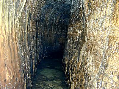
This is one of the shots I took yesterday. I think it’s better.

Curiously enough, some poster on a forum at dpreview.com asked a question a couple of days ago about how to get a good photo in Hezekiah’s Tunnel. Now that I had done some experimenting, I had an answer for him.
Here’s a lesser known aspect of the Pool of Siloam excavations. Most people know that the pool is fed by Hezekiah’s Tunnel, but they may not be aware of a second channel (known as Channel #2, or the Siloam Channel/Tunnel) which connects the Gihon Spring and the Pool of Siloam but on the east side of the City of David. This channel runs on the western slope above the Kidron Valley and it was once believed that it watered the King’s Gardens in the valley via a series of square openings.
One of those openings is on the southern end of the City of David. Here’s a photo taken in September 2002.

You can see that the opening looks square and the channel looks full of trash. Also note the street pavement and the crack in the bedrock in the upper left.
Eli Shukron’s recent excavations of the Pool of Siloam has included work on this channel, and our students have had some involvement in that (no glory here: more like cleaning out a sewer). But you can see the difference once the pavement has been removed and the channel cleared. Stephen’s head (on the left) is at about pavement level.
