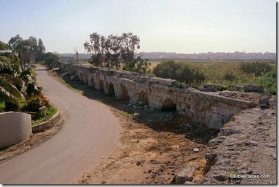
In the weekend edition of Haaretz, Moshe Gilad reports on a tour that explored the water sources of ancient Caesarea.
Two thousand years ago, Herod’s engineers devised a way to bring water to what was then the second largest city in the land, after Jerusalem, in terms of population. These were wise, exacting professionals who figured out the best route, and optimal height, for an aqueduct, so that the water would flow smoothly and calmly, without pumping systems, from the springs at the foot of Mount Carmel to the seashore.
[…]
The impetus for our tour was the recent publication of a book called “Water at the End of the Tunnel: To Tour the Ancient Waterworks” (published jointly by the Ben-Zvi Institute and the Israel Nature and Parks Authority, in Hebrew). Author Tzvika Tzuk, an archaeologist, studied the subject for years, and this serious and comprehensive work presents the information he gathered about the impressive engineering feats that allowed residents of this desert land, thousands of years ago, to enjoy a ready supply of drinking and bathing water. Tzuk’s guidebook proposes 40 routes for touring ancient waterways. Seven aqueducts reached Caesarea, he explains, and vestiges of many parts of them can still be seen. What is more, these days, any hike that ends at the beach will be particularly popular.
The article continues with recommendations of sites to visit, one of which is the section of aqueduct shown below.
HT: Joseph Lauer
