 The latest addition to Bible Places.com is a satellite map with the biblical sites marked. Now, what exists as of today is just a start. But with the amazing help of Jeremy Brown (famed creator of the Unbound Bible), the map is off to a good start.
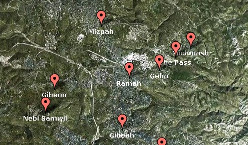
I’m using Google’s satellite map as the base, with all of the advantages that that brings (you can easily move around the map by clicking and dragging, zoom in and out, etc.). Then I have located about 80 biblical or ancient sites (so far) on the map.
If you look at the links at the bottom of the page, you’ll get an idea of where I can go with this. I can create maps specific to certain field trips (for my students), maps specific to certain regions (for linking from site pages in BiblePlaces.com or other websites), etc. There are many possibilities. My plan is to slowly add sites, descriptions, links, and other features.
The biggest disadvantage is the resolution of the maps. When you compare to sites in the U.S., for instance, you’ll see that the imagery for Israel is not nearly as high. I can see the backyard of the house where I grew up in the U.S., but in Israel I can’t pick out a single building in my community.
That’s one of the things you lose when the country has lots of enemies.
One thought on “Satellite Map with Biblical Sites”
Todd, this is so great. Thanks. What a wonderful teaching tool.