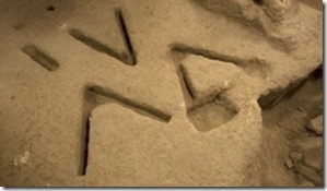
More than 20,000 people have offered suggestions as to the purpose of the mysterious marks recently uncovered by archaeologists in Jerusalem. From the Jerusalem Post:
Last week, Ir David Foundation head archeologist Eli Shukron told reporters he was so puzzled by the shapes – three V’s about 50 cm. long and 5 cm. deep – that he couldn’t begin to guess their function. The figures were found in a room near a spring, an important ritual area for the ancient city.
But Shukron’s bewilderment hasn’t stopped people around the world from offering their conjectures. Among the most interesting ideas: a torture device, drainage for ancient urinals, the original McDonald’s sign, an abbreviation for “veni vidi vici” (Latin for “I came, I saw, I conquered”), a footprint from King Solomon’s pet dinosaur, molds for smelting iron to make tools, the Trinity, a representation of mountains or the symbol for water, signs to the exit, an alien cryptogram, or support for a wooden structure.
Or perhaps, as one reader commented, “3,000 years ago, a worker said to his buddy, ‘I know how to drive archeologists crazy…’”

The marks remind me of preparation to cut a board. If these engravings are directly above Hezekiah’s Tunnel (and I don’t know that they are), I’d surmise that the outer arrows mark the edges of the cutting and the middle one marks the center point.
The full story is here. You can read the 20,000 comments and make your own here.
HT: Joseph Lauer
3 thoughts on “Proposals for Mysterious Marks in City of David”
Todd,
I am suggesting a ritualistic and/or celestial observatory purpose for these bedrock "marks".
From a time possibly preceding the building of Canaanite Jebus long before 8th century BCE, this mountain spring, in the Land of Moriah, was a daily destination from extreme antiquity, since it was one of a few water sources for travelers [both animals and people] along the north-to-south high ridge line … again, long BEFORE the first buildings of any kind were erected at this site.
All the ideas and PHOTOs on FB are interesting, but I am requesting more precise information to hopefully establish some useful context … such as:
[1] What is the mark's orientation relative to the cardinal directions?
[2] What is their orientation relative to the solstices and equinoxes?
[3] How accessible is the eastern and western horizons from this site in antiquity, before walls might have been constructed?
[4] Does the Mount of Olives southern ridge completely obscure the eastern horizon?
[5] Is this site DOWN so low that celestial/solar observation would be impossible?
[6] Exactly how far away were/is the spring's opening or nearest pools [in antiquity]?
[7] What specific direction is accessible water from the marks themselves?
[8] Shards and walls can be dated, but, could the marks pre-date the walls presumably erected circa 8th century BCE?
[9] Assuming the "V"s existence before any buildings were erected at Jebus, is it not possible they were originally cut for use out in the open air?
Obviously the marks in the bedrock could be older than the dated, 8th century BCE shards and walls surrounding them indicate. It is possible, right? Their original purpose could easily pre-date the earliest buildings of Canaanite Jebus. Imagine nomads stopping here centuries before buildings were ever built; before it was a fixed settlement. Imagine them camping by the spring and on this bedrock, performing some ritual or seasonal or celestial observation on this barren bedrock site … open to the starry sky.
Now, if they had an early pagan ritual purpose, perhaps they fell into disuse by the time of Kings David & Solomon [10th century BCE] and the building they were discovered within may simply have been erected around them [8th century BCE] for unrelated purposes … then, still later, filled-in with debris for assembling defense walls above. And, because the old marks are carved deep in the bedrock, they were simply ignored and are a part of these buildings recently uncovered.
If however the carvings' purposes were ongoing, then perhaps they were intentionally 'protected' within this building. Surrounding them with walls and presumably a rooftop would [of course] rule out any practical use as a celestial observatory. If they were part of a 'water' related ritual site, then a protected building may not be a problem.
I simply need to know more! Do you know someone who can answer my questions?
Daniel – interesting thoughts and questions. My guess on the location is that it is not ideal for gazing into the sky, but I really don't know much more than you from the articles. Some of your questions may need to wait for publication of the technical article, or perhaps you'll need to visit and make the observations yourself.
Look at this: http://www2.gol.com/users/stever/asukas.htm
Yes … it is in JAPAN, but it is similar and may have been used for astronomical purposes.