(by Chris McKinny)
Today, I was able to make it over to the Cura Aquarum conference on Water in Antiquity that was mentioned previously here. The first session of lectures dealt with several topics of interest for readers of this blog. Below I have added a few brief notes from the lectures.
Today, I was able to make it over to the Cura Aquarum conference on Water in Antiquity that was mentioned previously here. The first session of lectures dealt with several topics of interest for readers of this blog. Below I have added a few brief notes from the lectures.
1. Is There Light at the End of the Tunnel? The Gezer Water System Project – Dan Warner*, Tsvika Tsuk, Jim Parker and Dennis Cole
Warner gave an update of their project after two seasons and discussed their plans for the 2013 season. The following are a few difficulties that they have encountered and a few goals that the seek to accomplish in their project:
- Macalister’s plans of the system differ from the seemingly more accurate plans of Father Vincent (no great shock there).
 |
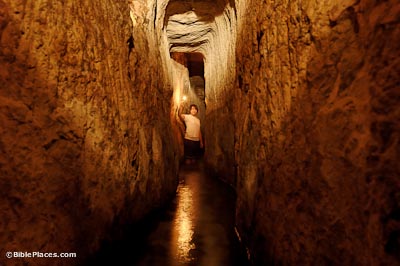
| Entrance to Gezer Water System |
- Macalister built a large retaining wall for the material that he removed from the system, however, that retaining wall collapsed towards the end of the Gezer expedition – re-filling the system back to 60% of its original fill level. This is what they have spent the last two seasons removing. They have successfully excavated two of the systems three parts – 1.) the “keyhole opening” (see pic above) and 2. the “stepped and sloping water shaft”. On the last few days of excavation this past season they reached the water cavern itself (part 3.). All told they have removed around 439 tons of fill so far.
- Vincent’s drawings seem to indicate that there was an opening or exit in the cavern section of the system. One of their goals is to determine the location or existence of this opening.
- Dating: While admitting to not finding any datable materials in their excavations, Warner concluded that he believes that the Gezer water system should be preliminarily dated to the Canaanite period/Middle Bronze Age. He dates the system based on its close proximity to the Middle Bronze Age fortifications (conta the site’s former excavator William Dever). He also made note of several “cultic niches” along the walls of the water system one of which has what he referred to as an embedded massebah (i.e. “standing stone”) similar to what is seen on top of the tell. If this system does in fact date to the Middle Bronze age, Warner theorized that it would then be one of the largest such systems from that time period in all of the ancient Near East.
2. A New Assessment of the Upper Aqueduct to Jerusalem: its Date and Route – David Amit and Shimon Gibson*
- Very nice presentation on all of the available date including some recent excavations near Jaffa Gate/Mamilla.
- Concludes that the Upper Aqueduct was originally constructed during the time of Herod the Great, in order to provide water for the Temple Mount and the Herodian Palace on the Western Hill of Jerusalem. They interpret the large amount of “10th Roman Legion” epigraphic evidence (i.e. bricks with the imprint of “XLEGFR”) around the Upper Aqueduct near Rachel’s Tomb as evidence of repair and not initial building.
3. Dating and engineering of Siloam Tunnel, Jerusalem – Amos Frumkin* and Aryeh Shimron
- Frumkin showed convincingly that the Siloam Tunnel (i.e. Hezekiah’s Tunnel) dates to around 700 BCE on the basis of a date range provided by the assessment of C14 (piece of charcoal found in the original plaster) and speleothems (stalactites). As both of these pieces of evidence fit the textual data, they concluded that the tunnel was dug by Hezekiah. On a side note, since both of the authors are geologists, it was very nice to see them consider all of the evidence including the biblical and extra-biblical texts. This has not always been the case with geological assessments of Hezekiah’s tunnel see here.
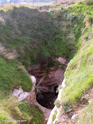
 |
| City of David with Hezekiah’s Tunnel in Blue |
- Frumkin also showed that Hezekiah’s tunnel was not excavated along natural karstic shafts. This common theory he referred to as the “Karst Theory.” Instead of following any natural, easier path for excavation, he demonstrated that the tunnel’s excavators passed through many bedding plates or fractures perpendicularly.
- Of even more importance, Frumkin provided some very interesting rationale for why Hezekiah’s tunnel meanders on both starting points instead of being excavated in a straight line. He believes that the entire excavation process was marked by changes “on the fly.” He comes to this conclusion based on the several “false starts” inside the shaft and the “semi-circular loops” on the north-eastern and south-western beginning points (he also makes the point that the NE starting point dropped 5 meters from its initial starting point, another indication of a mistake). Frumkin hypothesized that the excavators soon realized that they were not going to be able to find each other by digging in a direct line, diagonally across the city. So instead, both excavation teams began excavating towards the slopes of the Kidron Valley, an area much closer to the surface, with hopes that they would be able to “hear” one another above ground. Testing this hypothesis – Frumkin and Shimron’s claim that they were able to hear someone inside of the tunnel from directly above, which would mean that their theory is plausible, at the very least.
- Interestingly, Frumkin points out that this subterranean-to-above-ground communication could very well be what is meant in the Siloam Inscription where it reads, “… the tunnel … and this is the story of the tunnel while …the axes were against each other and while three cubits were left to cut? … the voice of a man … called to his counterpart” (italics mine).
All told, it was a very interesting set of lectures that showed that even old excavations can be given new interpretation and nuanced meaning through the advancements and developments of the discipline.
*Presenter


