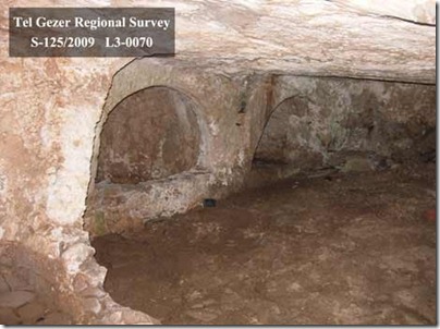
The Gezer Excavation Project includes a major regional survey under the direction of Eric Mitchell.
A preliminary report of the first five seasons (2007-2011) has now been published in Hadashot Arkheologiyot. Some excerpts:
Purpose: “The purpose of the project is to carry out a systematic high resolution archaeological survey of the region, within 1 km of Tel Gezer, and to locate and publish all features therein. This survey will aid in gaining a better understanding of the historical development of relationship between the ancient city of Gezer and its surrounding landscape.”
History: “The immediate vicinity of Tel Gezer has been investigated by R.A.S. Macalister who noted over 200 archaeological features within 1.5 km of the tell (Macalister 1912 III: Pl. VIII). In recent years, A. Shavit conducted a survey of the entire Gezer Map. Shavit noted that his survey was intensive but he was selective in the surveyed areas.”
Methodology: “To date, 1260 features have been recorded during the current investigations. Features are defined as any individual cultural element deposited on, built on, or carved into the landscape.
Therefore, with features such as winepresses, which include a basin, vat, channel, and cupmarks, each individual feature was added to the total and thus, the number of sites can be reduced significantly.”
Tombs: “Forty-one tombs were accessible for interior survey. Seven basic categories of tomb type have been encountered during the survey. These include tombs with irregularly shaped interior plans (6), simple bench-style tombs (4), arcosolium or recessed bench tombs (5), a distinct simple double arcosolia type (5), loculus or kokhim tombs (9), tombs with multiple styles (3), and tombs that are incomplete, partially filled, or otherwise do not fit into the above categories (9).”
Surface Visibility: “While modern and old disturbances could have easily hidden the existence of tombs, caves, and presses where agricultural land now stretches, the ploughed fields and orchards now offer excellent surface visibility and provide ample opportunity to observe and collect pottery, tesserae, and chert flake scatters, which would otherwise have been obscured by dense brush.”
Conclusions: “The results of the 2007–2011 Tel Gezer Survey seasons have been encouraging in terms of both artifacts and features documented, as well as total area covered. At the current rate, it is estimated that two to three additional seasons will be necessary to complete surveying a 1 km radius around Tel Gezer. Our goal for the future is to publish a catalog of features within our survey area, as well as articles on the tombs and presses of Tel Gezer. At the end of the project, we will analyze all our GPS location data for features and artifacts from every season via mapping software. Using this data, we can construct a clearer understanding of distribution patterns for various features, as well as draw wider conclusions about the use of the land around the ancient city of Gezer.”
The full report includes five images. Check out the official website for information about joining the team.
Photo by Tel Gezer Regional Survey
