Many visitors to Israel have visited the Nahal Zin and hiked into Ein Avdat. While witnessing the canyon’s spectacular views and wildlife, visitors will probably be informed that Nahal Zin was the southern border of the promised land (and thereby Canaan and the tribe of Judah) based on a connection between the large, continuous canyon (Arabic – Wadi el-Marra) and the southern boundary descriptions in the Bible (Num. 34:4; Josh. 15:3).
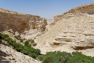 |
| Ein Avdat – BiblePlaces.com |
The identification of Wadi el-Marra with part of the Wilderness of Zin seems to be very plausible, even if the name “Nahal Zin” is a modern construction. Essentially, the identification of Wadi el-Marra with the southern boundary is based on the following two pieces of evidence: 1.) Wadi el-Marra is the only natural topographic boundary in the region and 2.) it is located between the Ascent of Akkrabim and Kadesh-barnea (Ein el-Qudeirat), which fits the biblical description. However, there is an additional piece of evidence that seems to make this identification even more secure – the location of Mount Halak at Jebel Halaq. Update – see here for Musil’s description of Jebel Halaq (German).
 |
| Southern Boundary Markers of Canaan/Judah on Karte Von Arabia Petraea (A. Musil 1906) |
This identification was made over a century ago by Alois Musil in his Karte Von Arabia Petraea who was told that the northern cliff face of Wadi el-Marra (i.e. Nahal Zin) was called Jebel Halaq by the local population. Since “jebel” means “mountain” in Arabic and the second part of the name is identical to the biblical place name, this identification was generally accepted. However, since the early cartographic projects did not cover the Negev Highlands (e.g., the Survey of Western Palestine, Van De Velde’s Map) most are unaware of this connection and its implications for biblical geography. Mount Halak is mentioned twice in the book of Joshua, in both cases it is within a north-south boundary description describing the territory that Joshua conquered.
“So Joshua took all that land, the hill country and all the Negeb and all the land of Goshen and the lowland and the Arabah and the hill country of Israel and its lowland from Mount Halak, which rises toward Seir, as far as Baal-gad in the Valley of Lebanon below Mount Hermon. And he captured all their kings and struck them and put them to death. Joshua made war a long time with all those kings.” (Josh. 11:16–18 ESV)
“And these are the kings of the land whom Joshua and the people of Israel defeated on the west side of the Jordan, from Baal-gad in the Valley of Lebanon to Mount Halak, that rises toward Seir” (Joshua 12:7 ESV)
 |
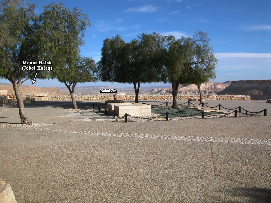
| Aerial view of Nahal Zin with view of Mount Halak (Jebel Halaq), photo by Bill Schlegel |
Jebel Halaq faces towards southern Jordan and the mountains of Edom (i.e. Mt. Seir), which matches the passages from Joshua. When we add Mount Halak (Jebel Halaq) to the accepted identifications of Tamar (En-Hazeva), the Ascent of Akkrabim (Roman road west of Tamar rising to Mamshit), and Kadesh-barnea (Ein el-Qudeirat), it is clear that the various boundary descriptions were describing the same border, which they demarcated using various topographical features (oases, mountains, and natural roads).
 |
| Ben-Gurion tombs with Nahal Zin and Mount Halak in background |
5 thoughts on “Mount Halak on the Southern Border of Canaan/Judah”
Have you seen my paper of November 2021 recently posted at Academia, on the internet, in which I argue that the Ascent of Akrabbim is NOT the Nagb es Sfar appearing on modern maps of Israel, after 1949? Why NOT? Excavations reveal this ascent was constructed in Nabatean times (4th century BC), and repaired in Roman and Byzantine times. I have proposed that the ascent of Akrabbim is probably further west of the Nagb es-Sfar, at Nagb el Gharib. In Arabic “scorpion is either a’jarib or a’garib, I have argued that Nagb Gharib is possibly a local dilectial form of A’garib/A’garib. Zin, preserved as Sin in the Greek Septuaginta Bible is probably preserved at Gebel es-Snab (today’s modern Israeli Har Rekhev).
thanks for the comment – this is an interesting idea – I will check it out!
Dear Chris McKinny, I understand that the Wilderness of Zin has been correctly identified by Israeli scholars (since 1949) with the drainage basin below Alois Musil’s Gebel Halak (1907).
Thank you for providing a link to Musil’s 1897 account of his visit to Gebel Halak, I enjoyed reading it.
Today that basin is called Biq’at Zin on modern Israeli maps and Atlases.
Also, of note, is that the Darb el Sultani apparently ends at wadi Marra on Musil’s map.
It then crosses Wadi Marra to ascend a track going by Gebel Halak, Musil’s Nakb el Rareb (today’s Naqb Garib, which for me is the ascent of Akrabbim) and continues on to Gaza, via Beersheba.
It is my understanding that Kadesh-Barnea is in the Biq’at Zin, and near the Darb el Sutani, just west of it.
From Kadesh, Moses asks to use the King’s way to cross over Edom, said request is denied.
IF scholars are right about the Darb el Sultani being the Way of the Kings, then, for Me, Kadesh is _in_ Biq’at Zin, and near the Darb el Sultani.
Joshua conquers all the land from Halak to Lebanon, elsewhere Joshua conquers all the land from Kadesh to Gaza.
I suspect Kadesh, Halak, and the Way of the kings are all to be found at Biq’at Zin.
For me, Ein Qadeis and Ein Qudeirat are TOO FAR SOUTH of the King’s Way to be in the Biq’at Zin.
For me, Wadi Marra preserves the waters of Meriboth-Kadesh.
The Rock, Hebrew SELAH, Moses struck to provide water for Israel to drink is a play on words for me, it is preserved in the Arabic ‘Asali region, a headwaters area of Wadi Marra.
The Darb el Sultani was in use in Early Bronze Age times. The Nabateans incorporated it in their great trade route from Petra to Gaza in the 4th century BC.
As Joshua conquers all the land from Halak to Lebanon (Josh 11:16-17) and Kadesh to Gaza (Josh 10:41), I understand the Biq’at Zin has been correctly located.
Flavius Josephus (ca. 70 AD) mentions Moses ‘ sister Miriam being buried on a mount called SIN, which I identify with Musil’s Gebal es Snab, todays Har Rekhev on modern Israeli maps.
I realize all of the above is highly speculative and not endorsed by any scholars I know of.
My above 2021 comments need to be retracted due to recent (today’s) understandings as of 21 May 2023.
The issue at hand is the statement in Joshua 12:7 about Mt. Halak rising toward Seir.
I now undertand, as of today, Joshua is saying Mt. Halak towers over the EDOMITE BORDER, which he calls Seir instead of Edom.
In the Bible, Seir is an alternate word for Edom.
Moses writes a letter to the King of Edom stating he is in a city in the uttermost border of Edom called Kadesh-barnea, he asks permission to cross the Edomite border and use the King’s Highway to get to Canaan, he will pay for water and food. His request is denied by the Edomite king.
So, as of today, 21 May 2023, it is my understanding that Joshua’s Mt. Halak going up to Seir, is referring to Edom’s western border to the west of the Arabah valley.
This makes sense with Moses’ statement Kadesh-barnea, a city, is at the uttermost of Edom’s border.
So two sites are being enumeratd as lying near Edom/Seir’s western border, west of the Arabah valley.
Regards,
Walter R. Mattfeld
(19 Ocober 2025) I have identified the ascent of Akrabbim with the Nagb Gharib east of Abde/Oboda.
Kadesh-barnea, for me, is Ain Kadeis.
Half-way between the Nagb Gharib and Ain Kadeis
is Wadi abu Sana (map of 1921 by the PEF, London).
I note the LXX renders Zin as Sena, perhaps
Sena is Wadi Abu Sana west of Abdeh/Obodah?