Arutz-7 has a helpful photo essay showing preparations for the Passover in Jerusalem. Subjects including cleaning out leaven, kashering pots, making matza, and an “educational” sacrifice.
The Jerusalem Post is reporting that stones in the Western Wall are crumbling. A little background:
The “Western Wall” is a 60-meter section of a 480-meter long western compound wall of Herod’s Temple Mount. This portion of the wall has been revered by Jewish people for centuries as a place of prayer because the temple does not exist and access to the temple court areas has been forbidden (either by rabbis or Muslim rulers or both).
Three distinct sections of construction are visible in the prayer portion of the Western Wall today.
The lowest seven courses (blue box in photo below) were constructed by King Herod in the 1st century B.C. The wall above this was destroyed, probably mostly in the Roman destruction of A.D. 70. Arab rulers in the 7th-8th centuries rebuilt part of the wall and these stones are visible above the Herodian stones (between blue and red boxes).
In the 19th century, there were problems with Muslims throwing objects and trash from the Temple Mount down on Jewish worshipers at the wall and so the British-Jewish philanthropist Moses Montefiore donated so that the wall could be built to a higher level. It is these stones (in red box) that are the subject of this JPost story. Read the article to learn more about whether the rabbis will permit restoration or not.
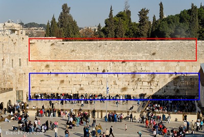
The crumbling stones are the smallest and most recent stones (red box).
The original Herodian stones are in the blue box.
Update (4/17): Leen Ritmeyer has a lengthy explanation of the situation on his blog.
A couple of developments in the land of the Philistines are worth noting:
A Philistine temple is being excavated at a site south of the five major Philistine cities. The temple dates to late Iron I (circa 1000 B.C.) and is a few miles south of biblical Gerar (Tel Haror) and northwest of Beersheba. Aren Maier has a brief report of his visit and some of the finds.
The Canaanite gate at Ashkelon has now been completely restored. They claim that it is the “oldest arched gate in the world,” but pushing the date of the Ashkelon gate a little earlier and the date of the Dan gate a little later. Even archaeologists are competitive! The JPost has a picture of the gate with a modern arch which looks like it was designed for schoolkids. Below is a photo before they added the arch.

Ashkelon Middle Bronze Gate (circa 1800 B.C.)
I recently worked on a project that required me to create some maps and I thought I might share a few tips for those who might be interested in making their own.
First, I’m using Bible Mapper. This program has lots of functions which makes it easy to add and remove cities, put labels, etc. The program used to cost $35, but it is now free. It does requires a free registration key from the author to unlock all of the features. (No technical support is available.)
Next, let’s say I want to make a map of Turkey. I only want to include certain places. This requires that I remove some of the ones listed. That’s easy. Adding sites that aren’t already defined is a bit more work. But this too is not hard with several free resources.
Let’s say I want to put Catal Huyuk on the map. This is an important Neolithic site, but it’s not already in the map program (I had to pick a lesser-known site like this one, because all of the biblical sites are already listed; if you’re just teaching about the biblical sites, you may never have to do this).
To get the location coordinates for it, I go to the Wikipedia article. I can then copy the coordinates to Google Earth, if I want to get a close-up look at the site with a satellite view (or to verify the coordinates). Alternately, I can click on the coordinates in Wikipedia which brings me to a list of maps that I can locate the site on, including Google Earth. It also gives the coordinates in decimal form which I can copy over to Bible Mapper.
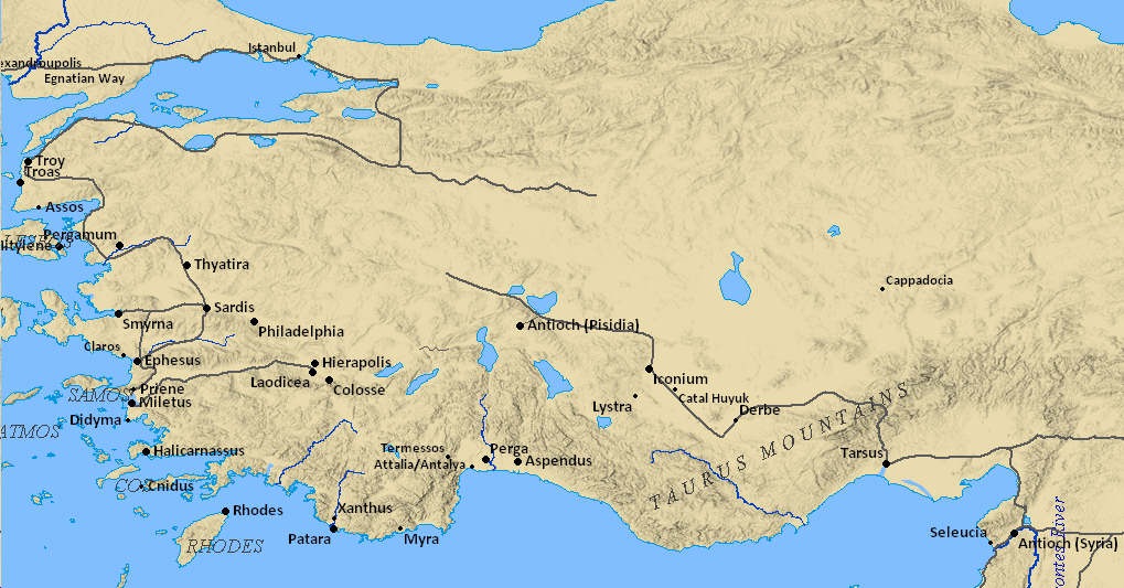
Here’s the map I made of Turkey. It took me about 30 minutes to create, but it would take less time for those who don’t have as many specific needs as I do. There is a learning curve in using the Bible Mapper program, which means that it’ll take you a little longer when you start. Undoubtedly more savvy individuals can make a much nicer map with all of the options available.
One day I hope to add maps like these to BiblePlaces.com so that one can click a site on the map and immediately go to the relevant page of photos.
Which reminds me – and this is a great feature of Bible Mapper – you can use the maps you create for anything! (From the license: “No copyright restrictions are placed on any maps created with Bible Mapper.”) Most maps and map programs have restrictions on them, which can make your maps of limited usefulness. Among its many other features, this makes Bible Mapper a terrific tool.