The best way to get up to speed on the major discoveries at Hazor from the Bronze Age is with Amnon Ben-Tor’s article on the ASOR Blog.

A brief report of the finds and surprises from the season at Gezer has been written by the excavators.

This year’s excavations of Gath are over, but Aren Maeir is making us wait for a summary of “one of the most productive, interesting and overall great seasons we have had since the project began (in 1996…).” Check out the rest of his blog for season-end photos.

Though most tourists skip Ashkelon, this Haaretz article reveals how the site is “a treasure full to bursting.”

I failed to note previously a couple of articles following up on the discovery of the “palace of David” at Khirbet Qeiyafa. A Baptist Press article provides some balanced coverage. And excavation volunteer Luke Chandler gives his personal perspective.

The theater in Assos is being renovated to accommodate events for up to 5,000 people.

Mark Wilson provides some background for 1 Corinthians 3:17 from the destruction of the Ephesian temple of Artemis.

The Oxford Encyclopedia of the Bible and Archaeology is now reduced to $235. It’s currently out of
stock, and I don’t know how long the discount will last. (This is an unusually large discount when compared with other Oxford sets such as OAENE, OEAGR, and OEBB.)

HT: Jack Sasson

Assos theater and acropolis from below, tb041605082
The theater and acropolis of Assos
Photo from the Pictorial Library of Bible Lands, Western Turkey
Share:

(Post by Seth M. Rodriquez)

In the 1970’s and 1980’s, the remains of several ancient harbors were identified around the Sea of Galilee. At least 13 harbors have been identified, all of which most likely date to the Hellenistic and Roman Periods. A map of the various harbors can be seen here. The work of archaeologists in this area (most notably, the labors of Mendel Nun) have provided us with significant insights into what life was like for fishermen who worked on the Sea of Galilee during these periods.

Our picture of the week comes from Volume 1 of the Pictorial Library of Bible Lands, and shows the remains of the main breakwater of the harbor of Susita (a.k.a., Hippos) on the southeastern shore of the Sea of Galilee. The photo was taken at a time when the water level in the lake was extremely low, so the breakwater stands several meters from the shore. However, in ancient times this breakwater would have provided boats with shelter from dangerous storms that can occur on the lake (for example, see Matt. 8:23-27).

This harbor was a typical one on the Sea of Galilee during this period. The breakwater was man-made and extended from the shore, enclosing an area of about an acre with a gap on the south end for boats to pass in and out.  In the map referenced above, the Hippos harbor can be seen at the bottom right.  Mendel Nun, in his book Ancient Anchorages and Harbours Around the Sea of Galilee (Kibbutz Ein Gev, Israel: Kinnereth Sailing Co., 1988), describes this harbor in the following way:

The harbour of Susita was built to fit the conditions of the sandy shore. The central breakwater is 120 meters long; its base is five to seven meters wide. The stone breakwater projecting from the shore turns to the south and runs nearly parallel to the shore at a depth of -211.25 meters [693 feet below sea level] for another 85 meters.

At the far end it curves sharply to the west and extends into the lake to a depth of -212.5 meters [697 feet below sea level]. This shape makes for a long inner area open to the south; a second breakwater was therefore constructed which extends from the shore for 40 meters. The inner part of the harbour thus formed a closed basin enclosing an area of about an acre. A small jetty leading north from the breakwater was for passengers embarking and disembarking, saving them the tedious procedure of passing through the narrow harbour entrance.  Indications that this entrance was deepended [sic.] may still be seen.

The total lenght [sic.] of all the breakwaters in this harbour comes to 180 meters.  The sides were built of rows of stones, the interstices filled with smaller rocks, re-used building stones, fragments of lime columns. During the past few years of low water, the silt filling the harbour has been overgrown by shrubbery.  (Nun, Ancient Anchorages and Harbours, pp. 13-14.)

Harbors such as this bear witness to the thriving economy around the lake during the time of Christ. Although people have probably always fished in the lake, the Roman Period was a time when fishermen were especially active and an unusually high number of settlements were constructed around the Sea of Galilee. According to Mendel Nun, “all settlements on the shores of the Sea of Galilee, even the smallest, had an anchorage, each built to suit local conditions and requirements.” (Ibid., p. 27.) So harbors such as this would have been part of the everyday life of people living next to the lake. Insights such as this add color to our reading of the stories in the Gospels.

This photograph and over 1,100 others are available in Volume 1 of the Pictorial Library of Bible Lands, and is available here for $39 (with free shipping).  Additional images of the Sea of Galilee can be found on the BiblePlaces website here and here, and on LifeintheHolyLand.com here.  Images and information about fishermen on the Sea of Galilee in the 19th century can be found here on LifeintheHolyLand.com.  Additional information about the ancient harbors around the Sea of Galilee can be found here.

Share:

The Hebrew University of Jerusalem issued the following press release this morning:


August Archaeology Outings: Hebrew University Invites the Public to Visit Fascinating Sites Throughout the Country


Jerusalem, July 22, 2013 — Researchers from the Hebrew University of Jerusalem’s Institute of Archaeology are inviting the public to participate in free guided tours of three diverse archaeological sites.

On August 2, 8 and 20, the archaeologists will lead tours that shed light on the rich history of some of Israel’s most fascinating ancient sites. At each of these locations they will offer a guided tour: Tel Dor (August 2), Ein Qashish (August 8), and Nahal Ein Gev (August 20).


Admission is free and there is no need to register in advance. Participants must bring hiking shoes, an adequate supply of water and a hat. Sunblock is recommended.


For more information, contact the Secretariat of the Institute of Archaeology at 02-5882404 or 02-5882403.


The tours:

Tel Dor

Host researcher: Prof. Ilan Sharon

Site visit date: Friday, August 2 at 8:30 a.m.

Meeting point: Hamizgaga Museum at Nachsholim

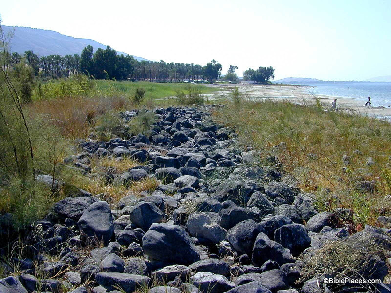
The site: Tel Dor is located on Israel’s Mediterranean coast, about 30 km south of Haifa. The documented history of the site begins in the Late Bronze Age and ends in the Crusader period. The port dominated the fortunes of the town throughout its 3000-odd year history. Dor was successively ruled by Canaanites, “sea peoples,” Israelites, Phoenicians, Assyrians, Persians, Greeks and Romans.

Its primary role in all these diverse cultures was that of a commercial entrepot and a gateway between East and West.

Map (how to get there) at http://dor.huji.ac.il/

Ein Qashish

Host researcher: Prof. Erella Hovers

Site visit date: Thursday, August 8 at 8:30 a.m. and 10:30 a.m.

Ein Qashish is an open-air Middle Paleolithic site located on the bank of the Qishon River, close to many of the major Middle Paleolithic cave sites in northern Israel, in an area where practically no open-air sites have been known before. The site was discovered in 2004 by survey teams of the Israel Antiquities Authority. Work at the site was carried out in 2005 and then again in 2009-2010 on behalf of the Institute of Archaeology at The Hebrew University of Jerusalem.

Map (how to get there): http://archaeology.huji.ac.il/qashish


Nahal Ein Gev

Host researchers: Prof. Anna Belfer Cohen, Prof. Ofer Bar-Yosef and Dr. Leore Grosman

Site visit date: Tuesday, August 20 at 8:30 a.m.

Meeting point: Entrance to Kibbutz Ein Gev

Nahal Ein Gev is located about 2 km east of the shores of the Kinneret. The site belongs to the Natufian period, about 11,500 years before our time, and exposes a village of the last hunter-gatherers who lived on the eve of the Agricultural Revolution, leaving complex and fascinating remains.

According to the incoming Head of the Institute of Archaeology, Prof. Erella Hovers, “A lot of the Institute of Archaeology’s activity is conducted on Mount Scopus in Jerusalem, but each summer the Institute’s scholars go to work on a large number of archaeological sites from different periods and in different regions in the country, thus taking research out of the lab and into the field. This is an opportunity for us to invite the public to experience the extensive research activities of the Hebrew University’s Institute of Archaeology as they unfold before us.”

Prof. Hovers added: “The archaeological sites are cultural treasures of the State of Israel and we are happy to reveal them directly to its people by hosting visitors our dig sites. We will gladly present how archaeological field work is done, what research questions led us to these excavation sites, and what 21st century archaeological science is all about.”


For information about the tours, contact the Secretariat of the Institute of Archaeology at 02-5882404 or 02-5882403.

Dor temples area, tb090506882
Tel Dor
Photo from the Pictorial Library of Bible Lands
Share:

The Jerusalem Post has a feature story on the current excavations at the Philistine city of Gath. For daily updates, see the excavator’s blog. In particular, you may want to check out this remarkable 3-D image of Area A.

The Post also reports on a new virtual tour of the Temple Mount, online at HarHakodesh.co.il.

The sphinx found at Hazor is described by the archaeologists in a 3-minute video. Apparently this was the last of 24 years of excavations at the site. UPDATE (7/19): My interpretation that this was the final season was incorrect. See comments below.

Tel Aviv University is offering a free online course via Coursera on “The Fall and Rise of Jerusalem,” taught by Professor Oded Lipschits, Ph.D. and Ido Koch.

John H. Hayes died last week at the age of 79.

HT: Joseph Lauer, Jack Sasson

Hazor upper city aerial from west, tbs112040011
The upper city of Hazor
Photo from the Pictorial Library of Bible Lands
Share:

The Hebrew University has announced the discovery of a fragment of an Egyptian sphinx. From the press release:

At a site in Tel Hazor National Park, north of the Sea of Galilee, archeologists from the Hebrew University of Jerusalem have unearthed part of a unique Sphinx belonging to one of the ancient pyramid-building pharaohs.
The Hazor Excavations are headed by Prof. Amnon Ben-Tor, the Yigael Yadin Professor in the Archaeology of Eretz Israel at the Hebrew University’s Institute of Archaeology, and Dr. Sharon Zuckerman, a lecturer at the Hebrew University’s Institute of Archaeology.
Working with a team from the Institute of Archaeology, they discovered part of a Sphinx brought over from Egypt, with a hieroglyphic inscription between its front legs. The inscription bears the name of the Egyptian king Mycerinus, who ruled in the third millennium BCE, more than 4,000 years ago. The king was one of the builders of the famous Giza pyramids.
As the only known Sphinx of this king discovered anywhere in the world — including in Egypt — the find at Hazor is an unexpected and important discovery. Moreover, it is only piece of a royal Sphinx sculpture discovered in the entire Levant area (the eastern part of the Mediterranean).
Along with the king’s name, the hieroglyphic inscription includes the descriptor “Beloved by the divine manifestation… that gave him eternal life.” According to Prof. Ben-Tor and Dr. Zuckerman, this text indicates that the Sphinx probably originated in the ancient city of Heliopolis (the city of ‘On’ in the Bible), north of modern Cairo.
The Sphinx was discovered in the destruction layer of Hazor that was destroyed during the 13th century BCE, at the entrance to the city palace. According to the archaeologists, it is highly unlikely that the Sphinx was brought to Hazor during the time of Mycerinus, since there is no record of any relationship between Egypt and Israel in the third millennium BCE.
More likely, the statue was brought to Israel in the second millennium BCE during the dynasty of the kings known as the Hyksos, who originated in Canaan. It could also have arrived during the 15th to 13th centuries BCE, when Canaan was under Egyptian rule, as a gift from an Egyptian king to the king of Hazor, which was the most important city in the southern Levant at the time.

The full press release is available here.

OLYMPUS DIGITAL CAMERA
hu130709_hazor_sphinx2
OLYMPUS DIGITAL CAMERA
All photos courtesy of archaeologists Prof. Amnon Ben-Tor and Dr. Sharon Zuckerman (shown above).
Share:

Ken Dark recently lectured at the University of Edinburgh on the archaeology of Nazareth and the Plain of Gennesaret (Ginosar). Summaries of these lectures are available online.

While I find highly dubious his suggestion that there was “no road between Nazareth and Sepphoris”—what sort of physical evidence would you expect to find for a road from an agricultural village of a few hundred people?—I am very interested in his claim to have discovered a “very large, but previously-unrecognised, Late Hellenistic, Roman-period, and later, settlement” between Magdala and Kibbutz Ginosar. He suggests that the site may be the Dalmanutha of Mark 8:10.

“About four thousand men were present. And having sent them away, he got into the boat with his disciples and went to the region of Dalmanutha. The Pharisees came and began to question Jesus. To test him, they asked him for a sign from heaven.” (Mark 8:9–11)

Because the parallel account in Matthew 15:38–16:1 has “vicinity of Magadan,” some scholars believe that Dalmanutha was another name for Magadan/Magdala. Mendel Nun has proposed that Dalmanutha be identified with a small anchorage north of Magdala (Anchor Bible Dictionary 2:4). Dalmanutha may not be a proper name but simply the Aramaic word for harbor.

You can read the lecture summaries and see the bibliographic details at the blog of the Centre for the Study of Christian Origins.

HT: Charles Savelle

Plain of Gennesaret from Arbel, tb032507715
Plain of Gennesaret (Ginosar) from Arbel. Is this the region of Dalmanutha?
Photo from the Pictorial Library of Bible Lands
Share: