A couple of new buildings in the Jewish Quarter provide good views from the rooftop or balcony.

Both cost but both provide unique perspectives that are worth the price of admission.

A one-hour tour of the Hurva Synagogue concludes on the balcony with views in all directions.

Jewish Quarter courtyard from Hurva Synagogue, tb010312412

Jewish Quarter from the Hurva Synagogue

For 10 shekels, you can get access to the rooftop of Aish HaTorah and its unobstructed view of the Western Wall plaza and Temple Mount.

Western Wall prayer plaza from southwest, tb010312492

Western Wall plaza and Temple Mount from Aish HaTorah

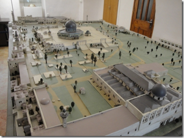
Aish HaTorah also has a model of the temple on display on the roof.

Temple model overlooking Temple Mount, tb010312511

Temple model on rooftop of Aish HaTorah

While on the rooftop a few weeks ago, I could see down into the area of the Temple Mount ramp that is otherwise blocked from public view by a fence. An archaeologist employed by the IAA was with a group of workers, leading me to wonder if any (quiet) progress is being made in the excavations there.

Share:

In his column today at the Jerusalem Post, Wayne Stiles traverses the length of the Western Wall underground, recommending this as an ideal way to get more out of your day in Jerusalem.

Traveling though these excavated tunnels a few weeks ago, I saw several discoveries made in recent years. The steps of a very large mikveh (ritual bath) are visible about 10 meters below the modern path (noted previously on this blog here).

Mikveh near Western Wall, tb010112167Eastern steps of mikveh built next to western wall of Temple Mount

Last month, they finished excavating and opened up to visitors a new portion of the Struthion Pool.

This is located to the east of the part of the pool that once served as the terminus of the tour.

Struthion Pool, tb010112215Struthion Pool
Excavations continue in the Great Hall, not far from the location of the largest stone in the Temple Mount.
New excavations in Western Wall tunnels, tb010112171Excavations in the Great Hall, January 2012
Share:

In Old City Odds ‘n Ends, Tom Powers reports on the clean-up of Hezekiah’s Pool, repairs at the Church of the Holy Sepulcher, and construction in Solomon’s Quarries. He also lists some posts he hopes to write in the months ahead.

Luke Chandler has some new photos of Khirbet Qeiyafa.

Over on the Accordance Forum, David Lang asks whether commercial graphics collections are useful in light of Google Images.

Larry Hurtado highly recommends the Atlas of the Early Christian World (1958).

The reformatted Soncino Babylonian Talmud is now available online.

In recent weeks, Wayne Stiles has taken readers of his column at the Jerusalem Post to Masada and the Citadel of David.

A 64th tomb has been discovered in Egypt’s Valley of the Kings. (The tomb of King Tut was number 62.)

Some thieves were caught looting a site in the Judean wilderness near Tekoa.

The Harvard Semitic Museum is baking thousands of ancient clay tablets.

HT: Jack Sasson, Joseph Lauer

Share:

Question: I read in a commentary the claim that the Dead Sea is visible from the top of the Mount of Olives. When I was there we didn’t go all the way to the top. Is this true? –K.P.


Answer: On most days you would not be able to answer this question because the air is so hazy. On a rare clear day, you would have this view just up the slope from Bethphage, with a sliver of the Dead Sea visible below the horizon.

Bethphage from Mount of Olives showing wilderness, mat02531

View of the Dead Sea from the Mount of Olives (photo source)
Share:

The proceedings of a conference at Haifa University in 2010 will soon be available in a 620-page book entitled The Ancient Near East in the 12th–10th Centuries BCE: Culture and History, edited by Gershon Galil, Ayelet Gilboa, Aren M. Maeir, and Dan’el Kahn.

Some chapters of particular interest to readers of this blog may include:

Walter Dietrich, David and the Philistines: Literature and History

Gershon Galil, Solomon’s Temple: Fiction or Reality?

Yosef Garfinkel, Saar Ganor and Michael G. Hasel, The Iron Age City of Khirbet Qeiyafa after 
four Seasons of Excavations

Moti Haiman, Geopolitical Aspects of the Southern Levant Desert in the 11th–10th Centuries BCE

Larry G. Herr, Jordan in the Iron I and IIB Periods

Victor Avigdor Hurowitz, Yhwh’s Exalted House Revisited: New Comparative Light on the Biblical Image of Solomon’s Temple

Dan´el Kahn, A Geo-Political and Historical Perspective of Merneptah’s Policy in Canaan

André Lemaire, West Semitic Epigraphy and the History of the Levant during the 12th–10th 
Centuries BCE

Aren M. Maeir, Insights on the Philistine Culture and Related Issues: An Overview of 15 Years of Work at Tell es-Safi/Gath

Troy Leiland Sagrillo, Šîšaq’s [Shishak’s] Army: 2 Chronicles 12:2–3 from an Egyptological Perspective

Ephraim Stern, Archaeological Remains of the Northern Sea People along the Sharon and Carmel Coasts and the Acco and Jezrael Valleys

Christoffer Theis and Peter van der Veen, Some “Provenanced” Egyptian Inscriptions from Jerusalem: A Preliminary Study of Old and New Evidence

And there is much more.

HT: Jack Sasson

Share:

While I’m traveling these weeks, I thought I might begin a new series of questions and answers. Over the last few months, I’ve written replies to inquiries from various friends and I will post one every few days.


Question: I have been working in Jeremiah and in 7:31 there is a reference the Valley of Ben Hinnom. Holladay suggests in his commentary (Jeremiah 1, 268) that the best identification of this valley is the Tyropoean Valley. The relevant paragraph is below. What do you think? –C.S.

The name of the valley is variously given as The Valley of Hinnom, The Valley of Ben- [= the Son of] Hinnom, or The Valley of Bene- [= the Sons of] Hinnom. Most authorities, following Gustaf Dalman, identify the valley with wādi ar-rabābi, the “Western Valley” which runs north-south, west of the Old City of Jerusalem, and then cuts east, meeting the Valley of Kidron. But other identifications have been proposed: Hugo Gressmann suggests wādi an-nār, the valley south of the junction between the Western Valley and the Valley of Kidron (and one notes that the Arabic name means “Valley of Hell”); and recently A. Douglas Tushingham has argued persuasively for the Tyropoean Valley, that is, the “Central Valley” running south from the southwest corner of the temple mount. Given the areas of occupation of Jerusalem in preexilic times, the Tyropoean Valley seems the best candidate.

valleys-of-jerusalemThe valleys of Jerusalem from the southwest


Answer: I don’t think I’ve run across this before, which by itself means that since this proposal was made in 1971 probably no one has accepted it (except apparently one commentator). Without reading Tushingham, but looking at Jeremiah 7:31, I can tell you that Tushingham’s motivation likely comes from his association with Kathleen Kenyon who believed, in 1971, in the “minimalist” view of Jerusalem—that the city never included the Western Hill before the Hasmonean period. So the Central Valley would fit the scenario described in Jeremiah 7 in that view.

But since we now know that the Central Valley was enclosed within the walls during the time of Jeremiah (and no one questions that anymore), the theory never gained any traction. Holladay published his commentary in 1986. By that time, there was unanimous agreement against the minimalist view. If Holladay had carried out research with more recent sources, he would have avoided this error.

Share: