If I were teaching a course in historical geography now to advanced students, I’d cancel one of the assignments and have them write a paper on the site identification of Khirbet Qeiyafa.  They would be required to use all of the available data in suggesting possible candidates.  Since I’m not teaching such a class, I can post my own thoughts here without fear of hindering their research.

It’s been a few weeks since I wrote about Kh. Qeiyafa, so a brief review is in order:  Located next to the Elah Valley where David fought Goliath, Kh. Qeiyafa has been excavated the last two seasons (2007-08).  This summer a 10th century B.C. inscription (ostracon) was discovered (photo), the contents of which have not yet been revealed, but may be very interesting.

The place to start in identifying Kh. Qeiyafa with a known historical place name is to look at the general area of the site.  Kh. Qeiyafa is located on the north side of the Elah Valley, roughly north of probable Socoh (Kh. Abbad/Kh. es-Suweikeh) and east of probable Azekah (Tell Zakariyeh).  Those last two identifications are generally agreed upon by scholars, but as far as I know there’s no certain proof of either identification (for a good discussion of Socoh and Azekah, see The Sacred Bridge, page 147).  That’s important to keep in mind as we proceed under the assumption that Abbad = Socoh and Zakariyeh = Azekah.

Early explorers who identified sites like Hazor, Beth Shemesh, and Beth Shean did not have the advantage of aerial photographs and Google Earth.  But since we have those at our disposal, we will put them to use.

You can locate Qeiyafa on Google Earth using this kmz file.

You can locate Qeiyafa on Google Maps with this link (via G. M. Grena)

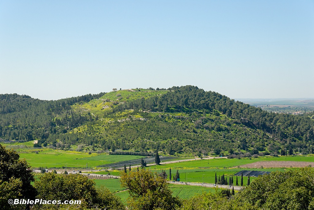
You can see the site in relation to Socoh (Abbad) and the Elah Valley on the photo below.

Elah Valley aerial from west, tb011606772_marked

Archaeology is critical in determining site identification, and Qeiyafa has remains dating to the early 10th century and to the Hellenistic period.  To do a thorough job in my little exercise, one would need to investigate Hellenistic sources concerning sites given in this area.  Because the occupation gap is so large (c. 800 years), it is possible that the Iron Age name was not preserved.  Since I am less knowledgeable about Hellenistic sources, and don’t have the necessary time, I am going to ignore this part of the equation.

The textual sources that we have for this time period are limited.  The Bible is the obvious place to start, though as I’ll note, some scholars question the traditional dates given to biblical texts.  Another source is the ostracon previously discussed.  It is possible that this ostracon has one or more place names and may single-handedly answer this question.  (Well, not really single-handedly, as it has to be in agreement with the rest of the data, but its relative importance is potentially great.)  Another possible source is Shishak’s conquest list as given on the Bubastite Portal in the Karnak Temple.

Since no other sites in the vicinity of the Elah Valley appear to be mentioned by Shishak, I am going to ignore that for now.

What can we learn from the Bible?  It might be instructive to note first that many scholars these days would sneer at this question.  It then would be worth reviewing just how many hundreds of accurate site identifications were made in the last 150 years, using the Bible as the primary source.  That is how Edward Robinson did it, as well as many successors on down to Yohanan Aharoni and his students and “grandstudents” (among whom I count myself).

A good place to start is with the passage of the battle of David and Goliath, as this was situated in the Elah Valley.  The setting is given in 1 Samuel 17:1:

Now the Philistines gathered their armies for battle. And they were gathered at Socoh, which belongs to Judah, and encamped between Socoh and Azekah, in Ephes-dammim (ESV).

Elah Valley aerial from west, tb011606779b
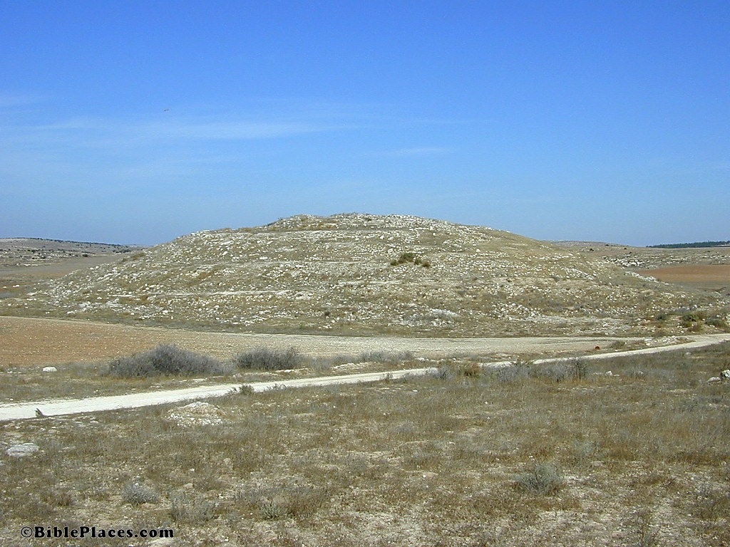
Aerial view of Elah Valley, view to southeast

While the locations of Socoh and Azekah are generally agreed upon (see above), the location of Ephes-dammim is uncertain.  Based on the above text, it seems that it is located “between” the two sites.  “Pas Dammim” is mentioned in 1 Chronicles 11:13 and could well be the same place, though the event described there is a different one than the David and Goliath story.  A parallel to 1 Chron 11:13 is given in 2 Samuel 23:9; the place name is lacking in the Masoretic Text but is given as “Pas Dammim” in the Septuagint.  These are the only references to Ephes/Pas Dammim in the Bible.

In teaching the David and Goliath story, I’ve pointed to the “gas station” (labeled on the first photo above) as a possible place for Ephes-dammim.  There’s no evidence for this, but since no other site has been identified and this sits neatly between Azekah and Socoh on the southern ridge of the valley, it was a convenient marker.

But now a new possibility arises: Could Khirbet Qeiyafa be Ephes-dammim?  There are three points in favor of this identification:

1) Like Ephes-dammim (ED), Qeiyafa is “between” Azekah and Socoh;

2) Like ED, Qeiyafa was inhabited in the 10th century;

3) Since the only textual references to ED are in the 10th century, and Qeiyafa was inhabited only in the 10th century (during the time of the Bible), this too would match. [Note: the biblical chronology seems to put the David/Goliath battle in the late 11th century, but the difference is only a few decades here and archaeology is usually not able to be very precise, especially at this period of time.]

swpelah Kiafa (Qeiyafa) is clearly between Azekah and Socoh; map from Survey of Western Palestine (1870s)

Some have suggested that the modern site of Damun preserves the name of Ephes-dammim, but as Steven Ortiz notes in the Eerdman’s Dictionary of the Bible (p. 411), Damum is 4 miles (6.5 km) northeast of Socoh when one would expect it to be west (and east of Azekah).

Another possible text that lists cities from the 10th century (though many scholars think it dates to much later) is the list of Rehoboam’s fortifications (2 Chronicles 11:5-10): “Rehoboam lived in Jerusalem and built up towns for defense in Judah: Bethlehem, Etam, Tekoa, Beth Zur, Soco, Adullam, Gath, Mareshah, Ziph, Adoraim, Lachish, Azekah, Zorah, Aijalon and Hebron.”  The location of nearly all of these sites is pretty well agreed on, not suggesting another possibility for Qeiyafa.

A text that many scholars would go to for sites is the city list of Judah from Joshua 15.  Clearly this is the best geographical list for the area, but I didn’t start there because I believe (hold your breath) that this list dates hundreds of years earlier than the 10th century.  Most scholars do not, and accordingly, I will not ignore it. Joshua 15:33-36 lists cities of Judah: “In the western foothills: Eshtaol, Zorah, Ashnah, Zanoah, En Gannim, Tappuah, Enam, Jarmuth, Adullam, Socoh, Azekah, Shaaraim, Adithaim and Gederah (or Gederothaim)—fourteen towns and their villages.”  The location of many of these cities is not positively identified.  Based on the sites whose identification is generally agreed on (Eshtaol, Zorah, Jarmuth, Adullam, Socoh, Azekah), the list seems to proceed from north to south.  The Elah Valley sites are all known (Adullam, Socoh, Azekah), and do not give us an extra name to associate with Qeiyafa, particularly between Socoh and Azekah as we might expect from 1 Sam 17:1.  If Joshua 15 is a pre-10th century text, then this is not surprising.

The “prophet of the Shephelah” is Micah, who lived in the late 8th century.  His hometown is given as Moresheth (probably known elsewhere as Moresheth-gath) in Micah 1:1.  He pronounces judgment on many cities in the Shephelah from 1:10-16, a number of which are unknown (particularly in vv. 11-12).  Too little is stated to pin down locations for these (Beth Ophrah, Shaphir, Zaanan, Beth Ezel, Maroth), but none is mentioned in connection with Adullam, a city on the eastern end of the Elah valley.  Again, I wouldn’t expect to find a relevant name here since Qeiyafa was apparently abandoned several hundred years earlier.

Elah Valley and Azekah view nw from Socoh, tb021707830 View from Socoh looking west towards Azekah

Are there other possibilities?  A quick check of Ahituv’s Canaanite Toponyms in Ancient Egyptian Documents, Tabula Imperii Romani, and Eusebius’s Onomasticon do not seem to suggest any other potential site names.

Was Kh. Qeiyafa a Philistine outpost?  This summer the excavations discovered a four-chambered
city gate and a 13-foot-wide (4 m) casemate wall. (Photos of excavations here and a 4-minute video of mostly still photos here.)  It certainly was a stronghold, and the only two known powers of the region at this time were the Philistines and the Israelites.  The Egyptians were back home enjoying their Third Intermediate Period, and there does not seem to be any strong contingent of Canaanites in the Shephelah (those would have likely migrated to where there were fewer enemies, such as the Jezreel Valley).

We can speculate further.  Perhaps Kh. Qeiyafa was Ephes-dammim, and it was constructed by the Israelites in the 11th century as they competed with Philistia for the Shephelah.  But one day the Philistines succeeded in capturing the fortress.  That brought Saul and the Israelites down to battle to regain their stronghold.  That could explain the otherwise curious reference in 1 Sam 17:1 to Ephes-dammim, as well as to giving its specific coordinates (since it was not well-known, then or later).

Unfortunately for the Israelites, Goliath wanted to make the battle a contest of champions and there was no one brave enough among the Israelites to respond.  The Israelites were encamped opposite the Philistines on the south side of the valley (which is the opposite of how I have always pictured it), or possibly in the hill country to the east.  David’s victory sent the Philistines fleeing towards Gath and Ekron (1 Sam 17:52), which makes perfect sense given the location of Kh. Qeiyafa.

While the above paragraph is speculative, the data that connects Qeiyafa with Ephes-dammim seems to me to be stronger than that which exists for many biblical sites.  The biblical text is very specific, and Qeiyafa matches exactly.  The dating of the fortress to the early 10th century is very close as well.  It’s certainly intriguing to consider.  Perhaps the ostracon discovered this summer will help to relate Kh. Qeiyafa to the biblical narrative, or even to confirm/deny the possibility that the site is biblical Ephes-dammim.  We’ll be interested to learn more when details are released.

I’m working on a lengthy (or two-part) post on Khirbet Qeiyafa, but in the meantime, the excavator of the site has given an update, summarized by G. M. Grena and posted on biblicalist:

Prof. Yossi Garfinkel, co-director of the excavation, has given me permission to share his team’s tentative publication schedule (quotes mark his exact words): 1) Their website "is under reorganization and shortly many photos of the site and the excavation will be available to the public." 2) They are still working on an official press release that should be ready "in a week or so." 3) They have already given the Israel Exploration Society "a preliminary text and 7 photos" for the "Notes and News section" of their journal, IEJ. 4) "A larger Hebrew article with 14 photos was given to a book conference to be published in 2 month[s]", but he wasn’t sure about the official name of the book yet. "The conference is a cooperation between the Institute of Archaeology of the Hebrew University and the Jerusalem district of the IAA. It will present to the public the latest results of research and excavations carried out in the Jerusalem area in the last year." http://www.elahfortress.com/
http://qeiyafa.huji.ac.il/
http://israelexplorationsociety.huji.ac.il/iej.htm
http://archaeology.huji.ac.il/

In a later post, the location of some new photos of a pottery presentation is given.

With regard to the Khirbet Qeiyafa inscription, there are those who know and those who don’t.  Those who know have been sworn to secrecy, leaving only those of us who don’t know to speculate.  I am happy to oblige and suggest below some reasons on why this inscription is significant, thereby possibly fueling more speculation by others also in the dark.

What is not speculation is the fact that the inscription is being studied by Haggai Misgav, a Northwest Semitic epigraphist (source).  Given the location of its discovery, this is no surprise, but it clearly rules out the possibility that inscription was written in another language.  Misgav Haggai says at present that his conclusions are “doubtful and temporary” and he does not know when he will be ready to publish (reported by Jim West).  That suggests that the inscription is difficult.  I offer some ideas that may explain archaeologist Aren Maier’s comment that this inscription “is going to be
VERY INTERESTING!!!!”

1. The inscription is long.  This is a guess based upon a photograph of the potsherd and a friend’s report that the inscription is 4-5 lines long.  Too many inscriptions are known only from a small portion preserved.  The recent ostracon found at Gath with a name similar to Goliath received much attention, but it contained only two words.

2. The inscription is meaningful.  This is in contrast to other early inscriptions, such as the Tel Zayit abecedary (10th c.) and the Izbet Sartah abecedary (11th c.).  Certainly alphabetic inscriptions are meaningful, and scholars can write much about them.  But the primary reason why they get so much attention is because there are few other contemporary inscriptions.  Sometimes conclusions about the state of writing are made that may be without warrant.  The combination of a brief or ambiguous text with a lack of contemporary material makes possible many wrong interpretations.

3. The inscription was discovered in a stratified context.  This is in contrast to the Gezer Calendar,
which was found in the debris pile in 1908.  The Tel Zayit abecedary was found in a wall, not in its original context.  Archaeologists do not have a clear stratigraphical context for many important inscriptions. 

4. The inscription is early.  Khirbet Qeiyafa has occupation from the 10th century and then a gap until the Hellenistic period (2nd c.).  The inscription certainly dates to the time of the settlement, which guarantees a 10th century date (assuming that the site itself has been correctly dated).  There are very few 10th century inscriptions in Israel, and all have some problems.  (The only 10th c. inscriptions from Israel that come to mind are the Gezer Calendar, Tel Zayit abecedary, and the Shishak inscription, but there are probably others.)  The significance of an inscription increases exponentially each century that you go back in time.  A seal impression in the city of David from the 6th century is less rare and thus less valuable than a letter or poem from the 10th century.

5. The inscription dates to a period now highly controversial in biblical archaeology.  In the mid-1990s Israel Finkelstein proposed a “Low Chronology,” which essentially re-dated all material believed to be from the 10th century to the 9th century.  The poor material culture from the 11th century was brought down to the 10th century.  Historically, then, Israel and Judah were impoverished and weak, or, more likely, non-existent (according to Finkelstein) at the time when the Bible describes the great United Monarchy.  Like so many theories in biblical archaeology, this one is highly dependent upon a large amount of “white space,” in which one’s own ideas can be inserted. 

Almost certainly this new inscription will fill in some of the gaps, as well as spawn its own controversies.

More speculating remains to be done on the site identification of Khirbet Qeiyafa, but that will need to await a future post.

G. M. Grena has noted in a comment below and on a post on biblicalist that a photo of the 10th century ostracon is apparently already online here.  You cannot see the inscription, but you get an idea for the size of the potsherd. 

Grena speculates further on biblicalist:

For those not who didn’t attend last year’s ASOR conference, Prof. Garfinkel had presented a paper, “Khirbet Kiafa: Biblical Azekah”:
http://lmlk.blogspot.com/2007/11/asor-2007-p-6.html
http://lmlk.wordpress.com/2007/11/22/asor-2007-p-6/
Though he did not reveal to me anything about the ostracon, in personal correspondence this morning he confirmed that Kiafa “cannot be” Azekah after having completed their first large scale excavation this past summer. Joseph Lauer also brought to my attention a Hebrew University of Jerusalem web page for the excavation, which states the same thing:
“In the past we suggested an identification with the biblical city of Azeka, but the dating of the Iron Age settlement to the early 10th century BC clearly dispro[ves] our first hypothesis.”
http://qeiyafa.huji.ac.il/history.asp
Normally, it would be somewhat embarrassing to have your thesis “ruined” so quickly (less than a year), but I’m guessing that with the new discovery, nobody associated with the work at this khirbet minds!

The statement that dating the site to the early 10th century means that it cannot be Azekah does not make sense to me, as the story of David and Goliath mentions Azekah at approximately this time (1 Sam 17:1).  Azekah also existed at the time of the Conquest (Joshua 10:10; 15:35), which means that any candidate for the site must have Late Bronze remains.

Another possibility, perhaps too good to suggest, is that the ostracon provides the biblical name of Khirbet Qeiyafa/Kiafa.

Aren Maier, excavator of Gath, was at a meeting in Jerusalem recently with a group of Israeli archaeologists and Yossi Garfinkel and Saar Ganor presented a newly discovered inscription from Khirbet Qeiyafa.  Maier reports on the ANE-2 list:

This absolutely fantastic, fortified Iron Age site (late Iron I/early Iron IIA) has a very nice assemblage of pottery, and what may be the most important Iron Age Semitic inscription found in Israel in the last decade! (to be published by Haggai Misgav of the Hebrew University).
I can’t give details about it, but OH BOY – this is going to be VERY INTERESTING!!!!
Clearly, the site, its dating, the finds, and their significance, will be of paramount importance in the discussions of the Iron Age southern Levant, and just about anything connected to it, in the near future.
Based on Yossi’s previous track record in publishing excavation results, publications should be appearing soon!

I doubt Maier is exaggerating, and this could provide some fun discussion in the months ahead.  It may help some readers if I spell out more of what Maier means by “the site, its dating, the finds, and their significance.”


The site: Khirbet Qeiyafa (aka the “Elah Fortress“) is located opposite Azekah along a ridge north of the Elah Valley, near the famous battle of David and Goliath.


The date: The site, and therefore presumably the inscription, dates to “late Iron I/early Iron IIA,” which is the scholarly way of saying “10th century B.C.”  David and Solomon were kings in Jerusalem in the 10th century.


The finds: Some of this has already been reported, but Maier probably is meaning the inscription itself, about which nothing has been revealed to the public.  I reported previously that the ostracon (inscribed potsherd) has 4-5 lines of writing.


Its significance: The major discussion in “biblical archaeology” right now centers on the 10th century.  The newer view (popularized in this book) denies that Judah was a nation-state until hundreds of years later, insisting that the biblical account of the United Monarchy is pure fabrication. 

Most archaeologists reject that view.  My guess is that Maier’s excitement is because this inscription will play a role in this discussion.


Other inscriptions: It may be worth noting that two (or three) other significant 10th century inscriptions were found in the same region.  To the north, Robert Alexander Stewart Macalister found the Gezer Calendar in the early 1900s. To the south, Ronald Tappy discovered an abecedary (alphabetic inscription) at Tell Zayit a few years ago.  To the west at Gath, Maier uncovered the “Goliath inscription,” which dates to the 10th or 9th centuries.  If you’re an archaeologist looking for a 10th century inscription, head for the Shephelah.

The Shephelah, or western foothills of Judah, is an ideal site for excavations because of

1) its rich history;

2) its close proximity to universities in both Tel Aviv and Jerusalem; and

3) its moderate climate.  There’s enough work to be done in the Shephelah alone to occupy every archaeologist working in Israel for the next 100 years.

Tel  Aviv University has been approved to renew excavations at Azekah.  Though it is one of the most important sites in the Shephelah, it has only been excavated by Robert Alexander Stuart Macalister in a brief dig more than 100 years ago.  Among other things, Azekah is mentioned in the Bible as near the place of the Philistine encampment when David defeated Goliath.  It was one of the last two cities holding out against Nebuchadnezzar in 586 B.C. (see Jeremiah 34:6-7 and Lachish Letter #4).  There are undoubtedly a lot of goodies buried under that pile of dirt.

Azekah from northeast, tb030407700
Azekah from the northeast

Bar Ilan University has been excavating Tel ‘Eton/Tell Aitun under the direction of Avi Faust.  This year was their third season of excavation and they are finding a destruction level as well as a fortress in the style of a four-room house, only larger. The destruction level seems to pre-date Sennacherib’s 701 campaign because pottery is transition form between Lachish III and IV; but also not likely to be Sargon II’s 712/711 campaign since it appears he only visited cities on the coastal plain. Scholars have suggested that the site is biblical Eglon (for more on that, see The Sacred Bridge, 128). The website is viewable in MS Internet Explorer, but not Firefox.

 Tell Aitun, possibly Eglon, from south, tb102900331
Tel ‘Eton, possibly biblical Eglon, from south

Khirbet Qeiyafa, located directly east of Azekah, is being excavated by Yosi Garfinkel of Hebrew University.  They found a four-chambered gate dating to the 10th century B.C. with a casemate wall and two attached buildings. There was no previous occupation and the nearest subsequent occupation is Hellenistic, so it is virtually a single-period site for Iron IIA. They also found an ostracon (inscribed potsherd) with about 4-5 lines of writing, the contents of which are apparently more sensitive than Israel’s plans to bomb Iran.  (This is a good reminder to thank those archaeologists who are quick to share their discoveries with all of their supporters.)  The ostracon will be published by Misgav.