If you’re not a subscriber to the BiblePlaces Newsletter (or if it landed in your spam box), you may not know that the Lebanon, Syria, and Jordan volume of The American Colony and Eric Matson Collection is now available. Here is one of my favorite photos from the CD:  This is an aerial view of Amman, looking down on the acropolis (foreground) and the ancient heart of the Roman city, including the theater. The acropolis is notable because it is almost untouched, whereas today it has roads, a museum, and many excavated areas. The area around the theater is now the center of a dense urban city. In biblical times, the city was known as Rabbah or Rabbath-ammon. In the Roman period, the city was called Philadelphia and was one of the cities of the Decapolis. My attempts to get in an airplane over the city have been unsuccessful, but the photo below will give you some idea of how the area has changed.
 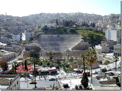 Amman theater from the acropolis The top photo is one of 25 photos of Amman in the Lebanon, Syria, and Jordan volume of The American Colony and Eric Matson Collection (Library of Congress, LC-matpc-13641). The bottom photo is from the Jordan volume of the Pictorial Library of Bible Lands.
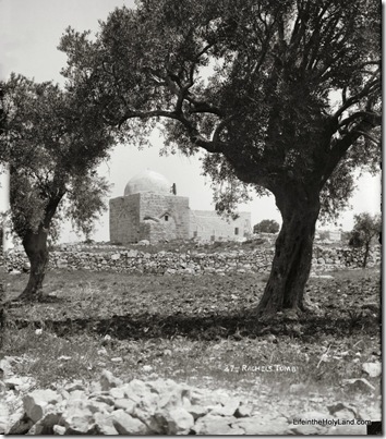
The traditional location of the tomb of Jacob’s beloved wife is located on the north side of Bethlehem, next to the main highway that has run from Jerusalem to Hebron for thousands of years now. The photo below gives a good idea of what the monument looked like in the early 1900s. It’s quite picturesque.
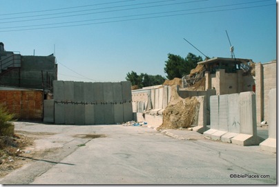
Today, it’s a little harder to get a photo (see below). The tomb is here, just behind that fortified IDF watchtower on the right. The ancient highway now has “walls reaching up to heaven,” and Joshua himself might have despaired of getting through.
The reason for such security is that the tomb is a holy site for some religious Jews, but the Arab city of Bethlehem has grown up around the tomb. When the Israelis built the partition wall, they designed its route so that the tomb and the road accessing it would stay on the Israeli side of the wall. In difficult days, even this protection is not enough and travel to the tomb is banned. The Palestinians who live next to the tomb can no longer cross the street.
Looking for a bright spot in all of this? How about this: the tomb has nothing to do with Rachel anyway. According to 1 Samuel 10:2, her tomb was in the tribal territory of Benjamin, which begins five miles north along the Hinnom Valley of Jerusalem. So all this expense and rancor is over Jews who want to pray at what likely was originally the tomb of a Muslim holy man!
The top photo is one of more than 550 photos included in the Southern Palestine volume of The American Colony and Eric Matson Collection (Library of Congress, LC-matpc-09188). For less than 4 cents a photo ($20/CD), you get a unique and outstanding collection of high-resolution photographs of Bethlehem, Hebron, the Shephelah, Tell Beit Mirsim, the Judean wilderness, Jericho, the Jordan River, the Dead Sea, Masada, Qumran, and the Negev.
- Tagged American Colony Photos, Judah, Then and Now
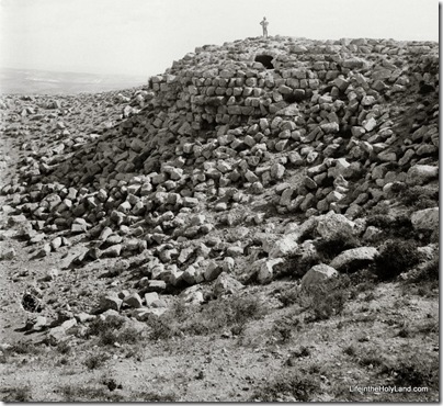
Early Western visitors were intrigued by a conical mountain about 4 miles (6 km) southeast of Bethlehem. Known by the Arabs as Jebel el Fureidis (Little Paradise Mountain), the site was believed to be the monument built by King Herod and named after himself.
Edward Robinson visited the site in 1838. He described his visit in his second volume of Biblical Researches in Palestine: “Leaving here our horses, a steep ascent of ten minutes brought us to the top of the mountain, which constitutes a circle of about seven hundred and fifty feet in circumference. The whole of this is enclosed by the ruined walls of a circular fortress, built of hewn stones of good size, with four massive round towers standing one at each of the cardinal points. . . . The tower upon the East is not so thoroughly destroyed as the rest” (170-71).
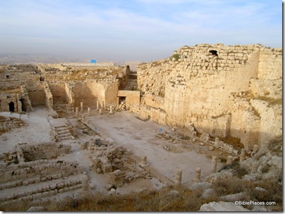
Today one can see how impressive that solid eastern tower is. Excavations began at Herodium in 1962 under the Franciscan Virgil Corbo. After Israel took the area in 1967, Ehud Netzer continued the archaeological work. Two years ago, Netzer discovered the long-sought-for tomb of Herod.
- Tagged American Colony Photos, Judah, Then and Now
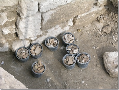
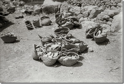
If you’ve ever thought it strange that they call them “pottery baskets” when they’re really just plastic buckets, the photo below may help.
This photo was taken in the first season of William F. Albright’s excavation of Tell Beit Mirsim (1926). It is one of 25 photos taken at the site included in the newly published Southern Palestine volume of The American Colony and Eric Matson Collection (originally Library of Congress, LC-matpc-05733).
- Tagged American Colony Photos, Technology, Then and Now
The waters of the Dead Sea rise and fall. You may not know that if you only read the newspapers and not the history books. Climate change has affected the earth as long as we can tell. There’s a great demonstration of the historically changing levels (and therefore shape) of the Dead Sea recently created by A.D. Riddle and David Parker. (After you click that link and read the introduction, click on the “Play” button on the right side and you’ll see the water level rise and fall.)
Evidence of the changing water levels is not so easily seen at the Dead Sea today. There is one spot on the northwestern corner (south of Qumran) where a marker made by the Palestine Exploration Fund in the early 1900s shows the level above today’s current highway.
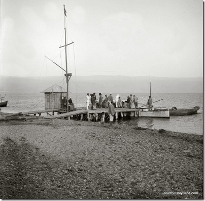
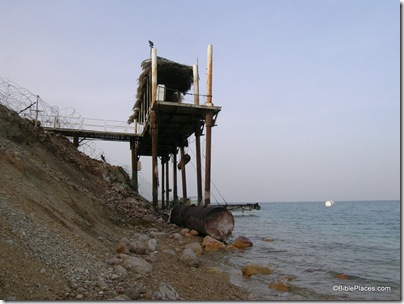
Another evidence is visible from boat docks. The photo below was taken by the American Colony sometime in the first half of the 20th century, showing passengers embarking on boats on the Dead Sea. Today there is little boat traffic and almost no windsurfers or waterskiiers. That’s not the only thing that has changed, as evidenced by the second photo below.
The photo below is not the same dock, but it illustrates the declining water level. This photo was included in a recent issue of Biblical Archaeology Review in an article making the same point.
The top photograph is from the newly published Southern Palestine volume of The American Colony and Eric Matson Collection (originally Library of Congress, LC-matpc-07571). It is one of a series of 65 photos of the western shore of the Dead Sea included in the collection.
- Tagged American Colony Photos, Dead Sea, Then and Now
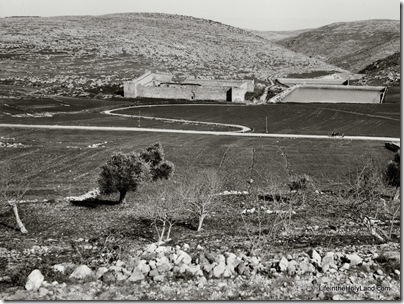
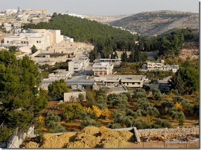
We’re not sure who built the enormous water reservoirs three miles south of Bethlehem, but there’s no evidence that they are related to their namesake. It is most likely that King Herod or one of his successors built these pools to supply Jerusalem with water. A complex and sophisticated series of aqueducts was constructed both to feed these three pools as well as to transport the water from here to multiple locations in Jerusalem.
The water system naturally required repair over the years, but it continued in use, off and on, through the British Mandate period. One evidence of the significance of these pools is the presence of a fortress built by Suleiman the Magnificent in the 16th century. (Yes, this is the same ruler who built the walls around the Old City of Jerusalem and constructed the fortress still standing at Aphek-Antipatris.)
The photo below was taken by the American Colony photographers in the early 1900s.
Today the area has changed dramatically, making it difficult even to locate Suleiman’s fortress. Other attempts that I have made to photograph the three pools have been thwarted by the forest that has been planted in the area.
The top photograph is from the newly published Southern Palestine volume of The American Colony and Eric Matson Collection (originally Library of Congress, LC-matpc-07571). The CD includes more than 550 high-resolution photographs from the Dead Sea, Jordan River, Jericho, Judean hill country, Shephelah, and Negev.
- Tagged American Colony Photos, Judah, Then and Now
The BiblePlaces Blog provides updates and analysis of the latest in biblical archaeology, history, and geography. Unless otherwise noted, the posts are written by Todd Bolen, PhD, Professor of Biblical Studies at The Master’s University.
As an Amazon Associate we earn from qualifying purchases. In any case, we will provide honest advice.
