fbpx
(Post by Seth M. Rodriquez)
Question: How much dirt does an archaeologist have to move? 
Answer: None. The volunteers do all the hard work.  😉
Actually, the answer to this question depends on the site.  Sometimes an archaeologist only has to scratch the surface and the Early Bronze Age or some other ancient period is revealed.  At other times, there is a massive amount of earth that has to be moved before the archaeologist gets down to the period he or she wants to study.  Here is a good example.
Our picture of the week, “Robinson’s Arch,” comes from a resource available through LifeInTheHolyLand.com, the sister site of BiblePlaces.com.  The resource is called Picturesque Palestine, Volume I: Jerusalem, Judah, and Ephraim.  It is part of the “Historic Views of the Holy Land” collection.  This was originally a book that was published in 1881 and edited by none other than Charles Wilson, one of the most prominent explorers of the Holy Land in the nineteenth century.  The book is a fascinating read as it discusses the landscape, holy sites, archaeological sites, and local culture as they appeared at that time.


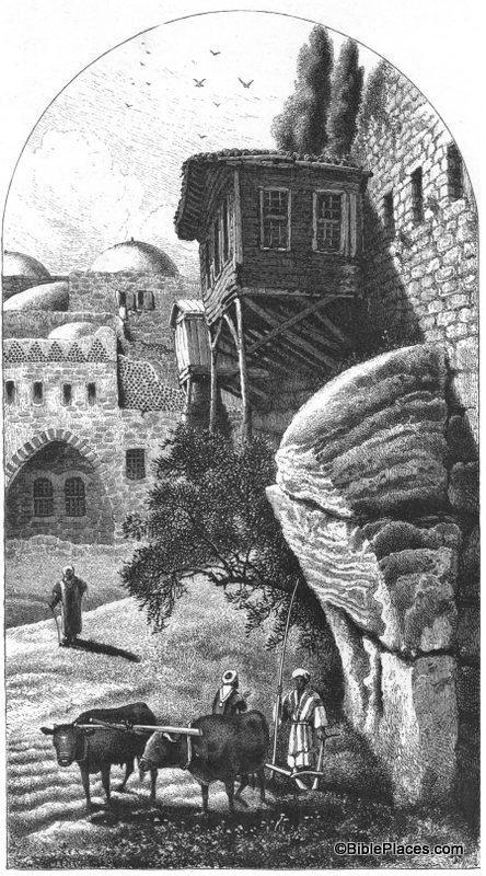
Robinson’s “Arch” is really just the lowest section of what was originally an arch.  It is called Robinson’s Arch because it was discovered by Edward Robinson in the 1830s.  You can see the remains of the arch on the right half of this drawing, towering above the two men and the oxen.  The arch originally spanned across the Tyropean Valley in Jerusalem and formed the upper section of a long stairway that provided access to the Temple Mount during the time of Christ.  (A reconstruction of this stairway can be seen here.)  The Tyropean Valley was filled in over the years, beginning with the destruction of the Temple by the Romans in A.D. 70.  Over the centuries the area was built up and torn down over and over again, accumulating debris until it looked like this in the nineteenth century.

Returning to our question (“How much dirt does an archaeologist have to move?”), archaeologists in the 1960s–1990s had to move several meters of debris during their excavation of this area.  The picture above is what the area looked like in the 1870s.  Compare that with what it looks like today:

This picture (taken from the Jerusalem volume of the PLBL) is looking at Robinson’s Arch from the opposite direction as the drawing in Picturesque Palestine.  The arch is at the top of the photograph and circled in red in this photo.  You can see that it now towers over the remains of the 1st-century street below.  If you look carefully, there is a person standing on the street looking up at the arch.  That gives you an idea of the massive amount of dirt and stone that had to be moved by the excavation teams in recent decades.

This is just one example of the value of a work such as Picturesque Palestine.  It allows us to roll back the clock and see how the land appeared to the nineteenth century explorers before the excavations of the last 100 years.

This and other pictures of nineteenth-century Jerusalem are available in Picturesque Palestine, Volume I: Jerusalem, Judah, and Ephraim and can be purchased here.  Additional historic images of the Temple Mount can be seen here and here on the LifeInTheHolyLand.com website.  Several websites related to this topic can be found on the BiblePlaces website here.

Share:
Damascus Gate and Old City, mat06658 Damascus Gate, early 1900s

This photo, taken by the American Colony photographers in approximately 1910, shows Damascus Gate on the northern side of the Old City of Jerusalem.  At the time, the Ottoman authorities were building new shops lining the street outside the gate.  These structures were removed in later years.

Notice also on the skyline of the Old City that the domes of the Hurvah and Tiferet Israel synagogues are visible.  These were both destroyed in the 1948 war.  The most prominent tower belongs to the Lutheran Church of the Redeemer, dedicated in 1898.  The domes on the right side belong to the Church of the Holy Sepulcher.

The recent photo below shows the area in the early morning before traffic picked up.

Damascus Gate, tb010310679

Damascus Gate, January 2010
Share:

One of the most important pieces of land in biblical history is the Central Benjamin Plateau, with the cities of Gibeah, Ramah, Gibeon, and Mizpah.

Excavations at Mizpah, mouth of old cistern, mat05515

Both of these photos were taken at Mizpah (Tell en-Nasbeh) with a view to the south.  The photo above was taken in 1926, before the area was densely settled. A tower is visible on the Mount of Olives in the distance.

Mizpah view to south with Jerusalem airport, tbs98319800
This photo was taken from the summit of Mizpah and the tell occupies most of the foreground.  The Jerusalem airport runway dominates the right side of the picture.  A tower on the Mount of Olives is visible on the horizon (center).

The top photo is from the Northern Palestine volume of The American Colony and Eric Matson Collection (Library of Congress, LC-matpc-05515). The bottom photo is from the Samaria volume of the Pictorial Library of Bible Lands.

Share:

“Of Jerash we may say generally, it is the best preserved of all the ruined cities east of Jordan. The ruins are weather-worn and beaten with the storms of centuries; earthquakes have shaken down many once splendid buildings, but there were no traces of the destroying hand of man” (William Ewing, Arab and Druze at Home, 1907).


Gerasa, general view of ruins from north, mat02743 Gerasa (Jerash) from north, approximately 1920 to 1933

“It is very noticeable that the ruins of Jerâsh up to the present day have been but little disturbed.

There has never been any great Moslem city in its neighbourhood, and hence its columns remain in situ or, thrown down by the earthquake, sprawling along the ground, while the stones of the Great Temple of the Sun and of the theatres are fortunate in having been, as yet, unpilfered for building material. Further, since there is in these regions no sand to drift over and veil the outlines, and the frequent drought preventing the ruins from becoming masked by vegetation, all that remains stands out, white and glaring, in noontide, having that same appearance of recent desolation which is so striking a characteristic of a freshly cleared streets of Pompeii” (Guy Le Strange, “Account of a Short Journey East of the Jordan,” Palestine Exploration Fund Quarterly Statement, 1885).


Gerasa city from south theater, tb052908616 Gerasa (Jerash) from south, May 2008

The top photo and both quotations are taken from the Lebanon, Syria, and Jordan volume of The American Colony and Eric Matson Collection (Library of Congress, LC-matpc-02743).

Share:

What is your favorite view in the Middle East?  I have a number of places that I aspire to be on the rare day when the air is crystal clear.  Perhaps my top three viewpoints in Israel are Nebi Samwil, Mount Carmel, and Arbel.  On the other side of the Jordan River, Mount Nebo ranks first. 

Unfortunately, I have never been there on a really clear day.

The photo below was taken in the 1930s, when factories and automobiles were less troublesome to photographers.  The view is from Mount Nebo, and you can see beyond the northern end of the Dead Sea to the Judean wilderness and even Jerusalem.

Dead Sea and Judean wilderness, view from Mt Nebo, mat03779
View from Mount Nebo with Dead Sea

I’m linking this photo to the highest resolution available (5200 x 3700 pixels), which will make it a slow download, but those of you with interest will be able to pick out a lot of detail.

For comparison, the photo below was taken from Mount Nebo on a more typical day.

Mt Nebo view to Dead Sea, tb031801859

The top photo is taken from the Lebanon, Syria, and Jordan volume of The American Colony and Eric Matson Collection (Library of Congress, LC-matpc-03779).  The bottom photo is rotten and will never appear in one of my photo collections.

Share: