fbpx

Nadav Shragai has written an extensive and interesting report of the newly discovered reservoir near the Temple Mount. If you’re interested in Jerusalem in the Old Testament period, this is a must-read.

2.5-minute video takes you inside the reservoir (Hebrew).

The Western Wall has passed its annual health check-up.

Excavation reports on the Mount of Olives reveal settlement in the OT and NT periods.

“I am the gate for the sheep,” said Jesus. A new 2-minute video short from SourceFlix illustrates what that means with footage from the Middle East.

Whether you love the water-soaked landscape of Caesarea Philippi or the parched terrain of the Judean wilderness, you can enjoy some great weekend reading, illustrated with slideshows and videos.

BibleX points to a couple of publications now online for the Church of the Holy Sepulcher in Jerusalem.

The IDF has begun clearing 700 mines from the Jordan Valley.

Sitting at the Feet of Rabbi Jesus, by Ann Spangler and Lois Tverberg, is marked down to $2.99 for Amazon Kindle for a few days.

Christianbook.com has some good deals on reference works beginning today:

HT: Joseph Lauer

Judean wilderness at sunset, tb021107716
The Judean wilderness at sunset
Share:
 
An interesting way to study or teach the scriptures is to take a site or geographic feature and collect all the verses that refer to that location.  Such a diachronic study reveals connections that aren’t otherwise readily apparent.  An excellent example of this is the Euphrates River which is mentioned in both Genesis and Revelation, as well as other places in the Bible.

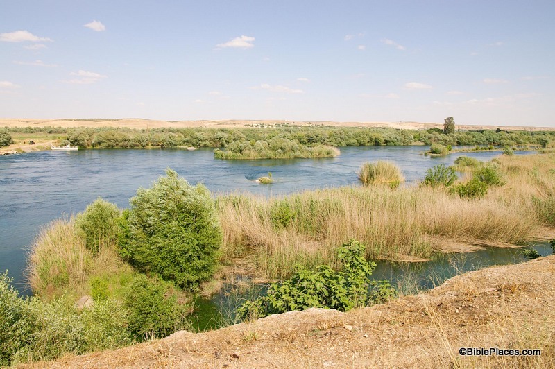
This week’s photo comes from Volume 9 of the revised and expanded edition of the Pictorial Library of Bible Lands, which focuses on Eastern and Central Turkey. The photo was taken by A.D. Riddle and is entitled “Euphrates River North of Carchemish View East” (photo ID #: adr1005191623).

In addition to our picture of the week, I would also like to highlight the valuable annotations that come with the PLBL collection.  The collection is not just a group of high resolution photos.  It also includes Microsoft® PowerPoint® files with excellent notes providing valuable information about the sites and images.  Over the years, I’ve found these notes to be a helpful, quick reference when I’m studying a certain site.  Often these notes will include a brief biblical survey of a particular location.  For example, the following information is provided in the PowerPoint® file on the Euphrates River:

The Euphrates River figures prominently in Scripture, being mentioned dozens of times from its first reference in Genesis 2:14 to the last reference in Revelation 16:12. The source of the river is in the mountains of Armenia northwest of Lake Van at an elevation of more than 10,790 feet (3,290 m). The river then flows through the modern countries of Turkey, Syria, and Iraq before merging with the Tigris River and emptying into the Persian Gulf, traveling a total distance of about 2,000 miles (3,200 km).
 

The Euphrates River in the Bible
1.   The Euphrates River is one of four that flowed from the Garden of Eden (Gen 2:14).
2.   The Lord promised to give Abraham the land between the Euphrates River and the river of Egypt (Gen 15:18; cf. Deut 1:7; 11:24; Josh 1:4; 24:2).
3.   Jacob fled from Laban across the Euphrates River (Gen 31:21).
4.   King David built a monument along the Euphrates River (2 Sam 8:3; 1 Chr 18:3).
5.   Solomon ruled over all the kingdoms as far north as the Euphrates River (1 Kgs 4:21, 24; 2 Chr 9:26; cf. Ps 72:8).
6.   The Lord promised to bring an invader from the other side of the Euphrates River (Isa 7:20; 8:7), but also to bring them back from exile from beyond the Euphrates River (Isa 11:15) and restore their dominion over the land “from the River to the ends of the earth” (Zech 9:10, LEB).
7.   Jeremiah accused the Israelites of faithlessness to the Lord by asking why they went to “drink the waters of the Euphrates” (Jer 2:18, LEB).
8.   The sixth angel will pour out his bowl on the Euphrates, causing it to dry up and allow passage of the enemy kings to attack Israel (Rev 16:12).

As you can see from the numerous verses listed above, a study of the Euphrates River takes you on a journey from Genesis to Revelation.  Along the way, you encounter Abraham, Jacob, David, Solomon, Isaiah, Jeremiah and others.  A study of this one geographic feature provides a platform for you to review (or have your students review) the entire arc of the biblical story, and it can provide a creative way for you to test your students’ knowledge of the Bible.  Try this as an essay question or an ice breaker in your next OT survey class:

“The Euphrates River is mentioned in Gen. 2:14, Gen. 15:18, Gen. 31:21, 2 Sam. 8:3, 1 Kgs. 4:21, Isa. 7:20, Jer. 2:18, and Rev. 16:12.  What is the biblical period and approximate date of each of these references?”

If a student can answer that question, then they know their stuff.  Most likely, you could drop them anywhere in the Bible and they will have their bearings.

This and other photos of the Euphrates River are included in Volume 9 of the Pictorial Library of Bible Lands and can be purchased here.

Share:

Excavations west of the Temple Mount have revealed a massive water reservoir from the Old Testament period. Over the last few years, archaeologists have been excavating the path of a 1st-century street and drainage channel leading from the City of David to the Temple Mount, and the reservoir was discovered during this work. The reservoir is similar to contemporary systems excavated at Beth Shemesh and Beersheba. From the Jerusalem Post:

The recently discovered reservoir, with an approximate capacity of 250 cubic meters, is one of the largest water reservoirs ever discovered from the First Temple period. Due to its size, archaeologists believe the reservoir was designed for and used by the general public.
According to Eli Shukron, the excavation director on behalf of the Israel Antiquities Authority, “the exposure of the current reservoir, as well as smaller cisterns that were revealed along the Tyropoeon Valley, unequivocally indicates that Jerusalem’s water consumption in the First Temple period was not solely based on the output of the Gihon Spring water works, but also on more available water resources such as the one we have just discovered.”

The Israel Antiquities Authority has issued a press release with more details.

According to Dr. Tvika Tsuk, chief archaeologist of the Nature and Parks Authority and an expert on ancient water systems, “The large water reservoir that was exposed, with two other cisterns nearby, is similar in its general shape and in the kind of plaster to the light yellow plaster that characterized the First Temple period and resembles the ancient water system that was previously exposed at Bet Shemesh. In addition, we can see the hand prints of the plasters left behind when they were adding the finishing touches to the plaster walls, just like in the water reservoirs of Tel Be’er Sheva, Tel Arad and Tel Bet Shemesh, which also date to the First Temple period.” Dr. Tsuk says, “Presumably the large water reservoir, which is situated near the Temple Mount, was used for the everyday activities of the Temple Mount itself and also by the pilgrims who went up to the Temple and required water for bathing and drinking.”
The exposure of the impressive water reservoir that lies below Robinson’s Arch joins a series of finds that were uncovered during recent excavations in this region of the city, indicating the existence of a densely built-up quarter that extended across the area west of the Temple Mount and predating the expansion of the Temple Mount. It seems that with the expansion of the Temple Mount compound to the west and the construction of the public buildings and the streets around the Temple Mount at the end of the Second Temple period, the buildings from the First Temple period and early Second Temple period were dismantled in this region and all that remains of them is a series of rock-cut installations, among them the hewn water reservoir.

A presentation about the discovery will be made this evening at the City of David Archaeological Conference. The Israel Antiquities Authority has released three high-resolution photos. The story is also reported by Arutz-7.

IMG_4745
Iron Age reservoir in Jerusalem
IMG_4672
Iron Age reservoir in Jerusalem. Photos by Vladimir Naykhin, IAA.
Share:

From The Temple Mount Sifting Project: On Thursday evening this week, September 6, 2012, the City of David will be hosting their 13th Annual Research Conference sponsored by the Megalim Institute. The program begins with an open house from 16:00 to 18:30 to give you an opportunity to visit the City of David and see all the newly excavated areas including the Second Temple Period street and water channel from the Siloam Pool up to the Temple Mount. The formal part of the program begins at 18:30. Admission is free and no registration is required, but space is limited. During the open house from 16:00 to 18:30, the Temple Mount Sifting Project will host an exhibit of finds recovered during the past 7 years of work.  The display, in the courtyard just inside the entry gates of the City of David, will include ancient seals and coins, personal items such as hair combs and jewelry, arrowheads, dice and game pieces, clay idols, weights, Herodian architectural elements and paving tiles that were once part of the Temple Mount plaza. This is the first time that these artifacts have been available for public viewing. Later in the evening as part of the Conference, at about 21:00, we will give a presentation [in Hebrew] of the Sifting Project’s important finds since our last Research Conference report, given in 2007. We will also be updating the public on our ongoing research and our new understandings about the Temple Mount’s past. Please stop by the City of David on Thursday evening to view this amazing exhibit of artifacts that helps tell the history of the Temple Mount. More information about the City of David Archaeological conference is here. HT: Joseph Lauer Sifting Temple Mount debris, tb110906729 Temple Mount Sifting Project

Share:

ARTIFAX Magazine is a little-known secret of biblical archaeology. If you are a member of the Near Eastern Archaeology Society (NEAS), you receive the quarterly magazine as part of your membership. If you do not, it’s quite possible that you’ve never heard of this magazine even though it’s now in its 27th year of publication. In every issue, ARTIFAX provides updates from the world of biblical archaeology, often excerpting articles from the local press of Israel, Jordan, Greece, and other countries. ARTIFAX also features original articles by various scholars, some you’re probably familiar with, and others you may not know. I’ve written several articles for the magazine over the years, and I always find it an interesting read. I don’t think I’ve ever recommended a subscription simply because there’s never been an easy way to subscribe. A new website changes that, and you can now subscribe with a few clicks of the mouse. I encourage you to check it out. Artifax, Spring 2012

Share:

About half a dozen new excavation reports were published yesterday at the IAA’s Hadashot Arkheologiyot, including three from Jerusalem: Mishkenot Sha’ananim – a section of the Low-Level Aqueduct from the Roman-Byzantine period and an earlier unknown period. This aqueduct brought water from Solomon’s Pools to Jerusalem. St. Claire’s Monastery, Talpiot – a section of the High-Level Aqueduct from the 1st-2nd centuries AD. Zedekiah’s Cave – co-sponsored by the [Ron] Wyatt Museum of Tennessee, this 2011 excavation focused on two areas in the lower level of the cave. Remains were found from the Arab and Crusader periods, but the ark of the covenant was not located. All reports include maps, plans, and photographs. Several other discoveries have been mentioned in recent days: Byzantine-era remains of Jewish town found 9 miles (15 km) north of Beersheba will require the re-routing of Israel’s new north-south toolway. Imported pottery from Cyprus discovered at Tel Burna in the Shephelah has been photographed. A figurine was discovered on the surface of Tell es-Safi/Gath by a student. 5386-6 Water channel excavated at St. Claire’s Monastery. Photo by IAA.

Share: