fbpx

Post by Seth M. Rodriquez, Ph.D.

“What do those words make you see?” Years ago, I worked as a reading tutor. It was my job to help people decode written words and understand the meaning being communicated through those words.

Reading comprehension experts will tell you that the best way to understand and remember what you read is to allow the words to create pictures in your head. As a tutor, I was trained to repeatedly ask the question: “What do those words make you see?”

It is no different when we read the Bible. As we read, we should allow the words on the page to form pictures in our head. Unfortunately, this can sometimes prove to be a challenge. Often we are not familiar with the places and things mentioned in the Bible. How tall was Mount Carmel where Elijah called down fire from heaven? How dry is the Judean Wilderness where David hid from Saul and where Jesus was tempted? What is a horned altar and what did look like?

Fortunately, today we have the means to bridge the gap between our world and the world of the Bible.
Collections of images provided through websites such as BiblePlaces.com and LifeintheHolyLand.com can go a long way in helping us to form vivid pictures in our minds of biblical places, characters, and events. To help you on the journey, I am kicking off a new series on this blog called, “On Location.” As the name implies, we’ll go “on location” with the people in the Bible. We will see some of the same sights they did … or at least see what these sights look like in modern times. The goal is to help you more accurately visualize the biblical stories.

To get things started, let’s talk about Abraham. Abraham’s journey started at the east end of the Fertile Crescent in the city of Ur in Mesopotamia. From there, he moved to Haran in the northern part of the Fertile Crescent, and eventually moved to the land of Canaan to the southwest. The story begins in Genesis 12 …

“Now the Lord said to Abram, ‘Go from your country and your kindred and your father’s house to the land that I will show you. And I will make of you a great nation, and I will bless you and make your name great, so that you will be a blessing. I will bless those who bless you, and him who dishonors you I will curse, and in you all the families of the earth shall be blessed.’ So Abram went, as the Lord had told him, and Lot went with him. Abram was seventy-five years old when he departed from Haran. And Abram took Sarai his wife, and Lot his brother’s son, and all their possessions that they had gathered, and the people that they had acquired in Haran, and they set out to go to the land of Canaan. When they came to the land of Canaan, Abram passed through the land to the place at Shechem, to the oak of Moreh. At that time the Canaanites were in the land. Then the Lord appeared to Abram and said, ‘To your offspring I will give this land.’ So he built there an altar to the Lord, who had appeared to him. (Genesis 12:1–7, ESV)


What do those words make you see? Let me help you out with the last few verses where Abraham enters Canaan for the first time and arrives at the site of Shechem. 
Shechem (modern Nablus) lies between Mount Gerizim and Mount Ebal in the very center of the land of Canaan. However, there is no indication archaeologically or in the biblical text that there was actually a city there in Abraham’s day. The city seems to have been founded in about 1900 B.C., about 200 years after Abraham would have passed through here. So to help paint our mental picture, we need to get out of the modern city located at the site of Shechem and see some wide open spaces nearby. In the image below, we are standing a few miles away from Shechem and we can see Mount Gerizim and Mount Ebal in the distance. This is similar to what Abraham would have seen back in 2100 B.C.
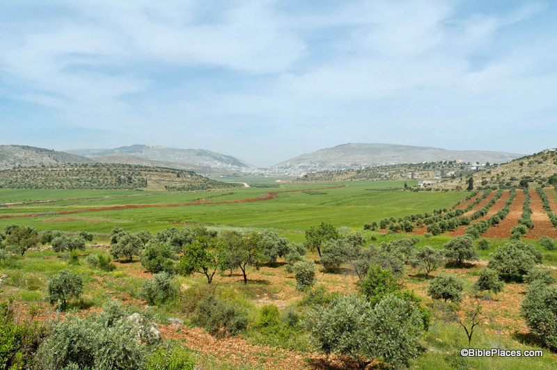
Mount Gerizim, Shechem, and Mount Ebal from the East

A close-up image of the Shechem area will help us complete our mental picture. The modern city sprawls over the area today. So to help us form a proper image in our minds, it is helpful to dig into one of the historic collections provided through LifeintheHolyLand.com and go back in time. This next image shows what the area between Mount Gerizim and Mount Ebal looked like about 100 years ago. The photographer is standing on Mount Gerizim and looking across the valley. In Abraham’s day, this area probably had many more trees than can be seen in the image below (Joshua 14 mentions a forest covering this region) but you can get a feel for what the topography is like through this photograph.

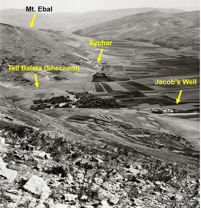
Looking north from Mount Gerizim (photo taken 1910-1920)

According to Genesis 12, this was the place where God spoke to Abraham shortly after he entered the land of Canaan for the first time. This is where He made Abraham the promise, “To your offspring I will give this land.” And in response, this is where Abraham built an altar to the Lord.

More images and information about Shechem can be found on the BiblePlaces website here.

Historical images of places from Abraham’s life can be found on the LifeintheHolyLand website here.
The images used in this post were taken from Vol. 2 of the Pictorial Library of Bible Lands (available for purchase here) and Vol. 1 of the American Colony and Eric Matson Collection (available for purchase here).

Share:

(Post by Seth M. Rodriquez)

Why did Paul have to land in a harbor about 150 miles from Rome and then walk the rest of the way?
In last week’s post, we discussed the Italian city of Puteoli, which served as Rome’s harbor for many years even though it is a significant distance from the capital. The book of Acts tells us that Paul ended his long and fateful sea voyage in this city:

And after one day a south wind sprang up, and on the second day we came to Puteoli. There we found brothers and were invited to stay with them for seven days. And so we came to Rome. (Acts 28:13b-14)

The reason Paul and his companions had to land at Puteoli was because it was the main harbor of Rome at that time. Although Rome sits on the Tiber River, the mouth of that river had become silted and shallow, so it was not a suitable harbor for the large ships transporting grain and other goods to the capital city. Nevertheless, the city of Ostia sat at the mouth of the Tiber River for many centuries before the time of Paul. The idea of dredging the mouth of the Tiber to make the harbor functional was first thought of at least as far back as the time of Julius Caesar in the mid-first century B.C. But the plan was not executed until much later, under the reign of Claudius in the mid-first century A.D., about the time Paul was traveling to Rome.


As you can see from the map above, the opening of a harbor near the city of Ostia greatly increased the efficiency of transporting goods to Rome by allowing the product to be delivered by boat only a short distance from Rome instead of having to be dragged 150 miles across a significant portion of the Italian peninsula. (Ostia is located in the upper left section of the image and Puteoli is located in the lower right section. Click on the image to enlarge it.) Naturally this was a boost for the city of Ostia, but eventually led to the demise of Puteoli.

The image above shows the square of the guilds in Ostia with the city’s theater in the background. As a major habor city, Ostia was home to several trade guilds. In this area there were 70 guild offices, many with a mosaic floor identifying which guild used the space. The customs officials also had their offices here. The Harper’s Bible Dictionary lists the following imports that flowed through Ostia: “grain, fruits, fish, meat, hides, oil, wine, minerals, jewelry, lumber, glass, paper, dyes, clothing, spices, ointment, and perfumes.”

The first century city also included a large government building, a temple to Augustus, a gymnasium, a bathhouse with impressive mosaic floors, a public latrine, and a synagogue … all of which are included in Volume 15 of the Pictorial Library of Bible Lands. A Decumanus about 1,200 meters long (3,840 feet) cut through the city. About two thirds of the city has been excavated, and a visit to the site today can give you a good feel for what it was like to live in a Roman city.

Many scholars believe that Paul was eventually released from captivity in Rome and left the capital to continue his mission of planting churches across the western Roman empire. On his journey away from Rome, it is possible that Paul passed through Ostia, however Ostia is not specifically mentioned in the Bible. So although Ostia was a significant city in its heyday, many students of the Bible have never heard of it and it consequently finds itself on our list of “obscure sites in the PLBL.

This concludes our series on “obscure sites in the PLBL.” The last three volumes of the collection focus on trees, plants, and flowers of the Holy Land; cultural images of the Holy Land; and signs of the Holy Land. These are excellent collections and highly recommended, but unfortunately they don’t fit in a series that focuses on obscure places.

On a personal note, I will be taking a break from our “Picture of the Week” series to focus on some other projects for a while. It has been over a year and a half since I started this series. (For those who may be interested, the first post of the series can be found here.) Over that time, I hope I have done justice to the extraordinary qualities of the various collections that have been compiled and edited by Todd Bolen. In a series of blog posts, it is impossible to capture all the fascinating items that are included in the Pictorial Library and Historic Views collections, but hopefully I have given you a taste of what you can find in these works … and whet your appetite for more.

The photograph and map above are included in Volume 15 of the Pictorial Library of Bible Lands, which is available here for $24 (with free shipping).  The excerpt is taken from “Ostia,” in Harper’s Bible Dictionary, edited by Paul J. Achtemeier, Logos Edition (San Francisco: Harper & Row, 1985).  For other posts in our series on “obscure sites in the PLBL,” see here.

Share:

(Post by Seth M. Rodriquez)

Where did Paul’s “fateful trip” finally end?  In a couple of my latest posts, we have been following Paul as he worked his way from Caesarea to Rome as a prisoner. When we last left him, he was on a ship that was intended for Phoenix on the southern coast of Crete, but instead the ship was blown off course and Paul and his companions were shipwrecked on the island of Malta.

Paul and his companions wintered on Malta (see here and here for pictures). Paul healed many people there and most likely spread the gospel in the area as best he could. When winter was over, Paul and his escort of Roman soldiers were finally able to board another ship and travel to Rome. Our “obscure site” this week is the place where they landed for the last time. After making brief stops at Syracuse and Rhegium, Paul finally ended his long sea journey at the harbor city of Puteoli:

After three months we set sail in a ship that had wintered in the island, a ship of Alexandria, with the twin gods as a figurehead. Putting in at Syracuse, we stayed there for three days. And from there we made a circuit and arrived at Rhegium. And after one day a south wind spring up, and on the second day we came to Puteoli. There we found brothers and were invited to stay with them for seven days. And so we came to Rome. (Acts 28:11-14, ESV.)

In the map above, Puteoli is located in the bottom right (click on the image to enlarge). Puteoli had a population of about 100,000 people at this time. Its importance was tied to the fact that the Italian Peninsula does not have very many good harbors. Puteoli was one of the few harbors that were deep enough and protected enough to be of much use to the Romans. And since, for many years, it was the closest good harbor to Rome, it was the main harbor of the capital city and commerce streamed in and out of this port. Much of the wealth of the Roman Empire flowed through this spot.


Of course, when we say it was close to Rome, “close” is a relative term. Puteoli actually sits about 150 miles away. From here, Paul had to travel north on the Via Consularis until he reached the city of Capua, and there stepped onto the Appian Way which finally took him to Rome. To continue Paul’s journey and to see a picture of the Appian Way from the PLBL, see my previous post here.


This photograph and map are available in Volume 14 of the Pictorial Library of Bible Lands, and is available here for $24 (with free shipping). Additional images of Puteoli can be seen on the BiblePlaces website here. For other posts in our series on “obscure sites in the PLBL,” see here.
Share:

(Post by Seth M. Rodriquez)

Continuing our series on “obscure sites” in the PLBL, today we come to a site so obscure that no biblical character ever visited this place, although it is mentioned in the book of Acts.

In an earlier post, we discussed the city of Myra where Paul briefly stopped as he was being transported to Rome. It was there that Paul and his escort of Roman soldiers boarded a grain ship that was traveling to Rome (Acts 27:5-6), but this ship was destined never to arrive. It made it as far as Fair Havens on the southern coast of Crete (Acts 27:8). By this time, the season was changing and winter was coming, but Fair Havens was not a good place to spend the winter because the wind blew right into the harbor. (See here for more information on that topic.) Although Paul warned them not to go any farther, the pilot, the boat owner, and the centurion decided to try to reach another city on the southern coast of Crete: the city of Phoenix (Acts. 27:9-12).

They never made it.

So Phoenix ends up on our list of obscure sites, instead of being trumpeted as the winter quarters of the Apostle Paul. Meanwhile, Paul and his companions were lost at sea and were eventually shipwrecked on a reef off the coast of Malta. On the map below, you can see Fair Havens (where they started) on the southern coast of Crete in the center of the picture, and you can see Phoenix (where they intended to land) to the west  of there (click on the image to enlarge). As you can see from the measurement scale, it was only a distance of about 80 kilometers (50 miles).

Here is the site of Phoenix as it appears today (click on the photo for a higher resolution):

There is one fascinating detail of the description of Phoenix in Acts 27. Luke tells us it is “a harbor of Crete, facing both southwest and northwest” (Acts 27:12). As you can see, the ancient city of Phoenix was built on a promontory, which in modern times is called Cape Mauros. The modern village of Loutro uses a beautiful harbor on the east side of Cape Mauros, located just over the hill in the left side of the picture above. However, in ancient times, the inhabitants of Phoenix used the harbor on the west, and there is still evidence today that the ancient western harbor had two inlets. The one that faces southwest still survives today. The one the faces northwest is harder to see because the waterline is much lower that it was in antiquity and because a rocky reef that extends west from the tip of the cape would have extended farther in the first century than it does now. This reef would have helped to form one side of the northwest inlet.

In the picture above (taken from the PowerPoint presentation included in Volume 13 of the PLBL) the site of Phoenix, the reef, and the southwest and northwest inlets of the harbor are marked. For more information on this topic, you can consult the annotations in that PowerPoint presentation, the information posted here on the BiblePlaces website, or an article by R. M. Ogilvie in the Journal of Theological Studies, vol. 9 (1958), pp. 308-314. The geographical details of Luke’s accounts in the book of Acts have long been praised as extremely accurate. This is just one example among many that Luke knew what he was talking about.

This photo and map are available in Volume 13 of the Pictorial Library of Bible Lands and is available here for $24 (with free shipping). Additional photos and information about Phoenix are available here on the BiblePlaces website, as well as photos and information about these other locations on the island of Crete: Fair Havens, Gortyn, and Knossos.  For other posts in our series on “obscure sites in the PLBL,” see here.

Share:

(Post by Seth M. Rodriquez)


Our “obscure site” for the week is the Roman city of Mitylene, a city that Paul visited during his third missionary journey. (Click on the map above to see its location on an island off the coast of modern Turkey.)  If you don’t remember reading about this city in the New Testament, don’t feel too bad. It is only mentioned in passing and Paul spent less than a day there while he was traveling back to Jerusalem. Perhaps the best way to remember it is to tie it to the story of Eutychus.

Eutychus was the young man (or boy) who fell asleep while listening to Paul preach late into the night. Unfortunately, Eutychus was sitting in a window sill and fell to the ground from the third floor after he dozed off. Luke writes that he was “picked up dead” (Acts 20:9, NASB). But fortunately Paul miraculously brought him back to life (Acts 20:10-12). This happened in Troas on the western shore of Asia Minor (modern Turkey). Paul left Troas the next day, walked twenty miles to the city of Assos, and then boarded a ship where Luke was waiting for him. Luke continues the story by saying:

And when he met us at Assos, we took him on board and came to Mitylene. Sailing from there, we arrived the following day opposite Chios; and the next day we crossed over to Samos; and the day following we came to Miletus. For Paul had decided to sail past Ephesus so that he would not have to spend time in Asia; for he was hurrying to be in Jerusalem, if possible, on the day of Pentecost. (Acts 20:14-16, NASB)

So only a few days after raising Eutychus, we find Paul in Mitylene. This passage makes clear that Paul was quickly moving through this territory and it is not even clear that he set foot on the island of Lesbos where this city is located. Consequently, the city finds itself on our list of “obscure sites in the Pictorial Library of the Holy Land” instead of prominently displayed on the BiblePlaces website along with Samos, Miletus, and Ephesus.

In the image above, you can see the modern city of Mitylene through the window of a medieval castle that sits on the city’s peninsula. This peninsula is actually man-made, similar to the one at Tyre. The castle sits on what was once an island that stood a short distance from the shore. At some point in the city’s history, a causeway was constructed from the shore to the island, and subsequently two harbors were formed (one of which probably sheltered Paul’s ship during the night he was there). The ancient city was inhabited from about 1200 B.C. until A.D. 151 when it was destroyed by an earthquake. In addition to the apostle Paul, the city also played host to Aristotle and Epicurus during its long history.

Now, you probably did not get up this morning and expect to read a blog post about the obscure city of Mitylene or the biblical story of Paul and Eutychus, but this post illustrates an interesting phenomenon … We are curious creatures and images have a way of drawing us into a story. They lead us to want to know more. If you are a teacher, a preacher, a professional in the corporate world … someone who stands up in front of people and delivers information verbally … you should take note of this and use it to your advantage. We live in a visual culture. We also live in a generation that has resources which previous generations could only dream of, if they could imagine them at all. We have at our fingertips photographs and illustrations of places and things all over the world! So the next time you stand up to talk about obscure (or not-so-obscure) topics, start with a photograph. Draw your listeners in by using an image as a springboard to your discussion. Equip yourself with collections such as the Pictorial Library of Bible Lands, Historic Views of the Holy Land, or something similar that exists in your field of expertise. Then use people’s natural curiosity to lead them where you want them to go. Once you have their attention, you can take them anywhere.

This photo is available in Volume 12 of the Pictorial Library of Bible Lands and is available here for $24 (with free shipping). This volume focuses on the Greek Islands, and includes the islands of Samothrace, Samos, Patmos, Cos, Rhodes, and others.

Share:

(Post by Seth M. Rodriquez)

Our “obscure site” for the week was the location of a famous haircut.  Acts 18:18 tells us, “After this, Paul stayed many days longer [in Corinth] and then took leave of the brothers and set sail for Syria, and with him Priscilla and Aquila. At Cenchreae he had cut his hair, for he was under a vow.” (ESV)

The city of Cenchrea (or Cenchreae) was a port city near the Corinthian isthmus in Greece.  Paul was on his second missionary journey and had just completed his 18-month stay in the city of Corinth

When he passed through Cenchrea, he was reaching the end of his journey.  After this, he made a short stop at Ephesus, and then continued on to Caesarea, Jerusalem, and finally Antioch where he started his journey.  Cenchrea is also mentioned in Romans 16:1 where Paul mentions a lady named Phoebe who served the church in that city.

In the photograph below you can see the harbor of Cenchrea. This city served as the eastern port of Corinth, which explains why Paul passed through here on his way back to Jerusalem and Antioch.

John McRay, in his book Archaeology and the New Testament, provides the following information about Cenchrea:

Virtually nothing has been found of the main city of Cenchreae, which lay northwest of the harbor, because during five seasons of excavation from 1963 to 1968 the government restricted work to the harbor except in 1966. … The picturesque harbor thus far excavated, dates to the Roman period. … The Roman harbor originally contained about 1600 feet of shoreline and was 98,000 square feet. In comparison with other Greek and Roman harbors, this one was rather small …. Two large breakwaters, were constructed around a natural bay. The modern shore is about 7.5 feet lower than during New Testament times, due to seismic activity. The harbor’s breakwaters or moles are completely submerged. Pottery and coins give evidence to a city whose commercial life, prosperity, and general status was inextricably tied to Corinth’s. Almost all the coins uncovered have been of Greek mintage or from the eastern Mediterranean, confirming that Cenchrea’s commercial significance was the link it provided between Corinth and the east.

It is unfortunate that further excavations of the site have not been allowed, but that probably explains why we have not yet found the hair that was cut from Paul’s head. 😉

This map and photograph, along with over 800 other images, are available in Volume 11 of the Pictorial Library of Bible Lands, which can be purchased here for $34 (with free shipping).  Another photograph of the harbor at Cenchrea can be seen here on the BiblePlaces website. Ferrell Jenkins has a picture of the harbor available on his blog here. For other posts in our series on “obscure sites in the PLBL,” see here.

The excerpt is taken from John McRay, Archaeology and the New Testament (Grand Rapids: Baker Book House, 1991), pp. 336-337.

Share: