Nir Hasson writes of Israel’s efforts to survey the whole country for any signs of man-made activity from the past. Archaeologist Adam Zertal has worked on the survey for the last 34 years and is the focus of the report in Haaretz.
“It could be said there isn’t a meter we haven’t covered,” says Prof. Zertal, who walks using crutches, a remnant of an injury from the 1973 Yom Kippur War. “Walking is my rehabilitation. I walk slowly with crutches. The younger guys go much faster.”
This is how the national archaeological survey, one of Israel’s longest-running scientific projects, is being carried out. The aim is to clamber down every ravine, scale every hill and walk through every furrow in the country.
The Israel Antiquities Authority seeks to precisely map every historical and archaeological site west of the Jordan. The project, which began in 1964, is due to end – if at all – in a few decades.
Six years ago the authority stopped publishing thick volumes of the survey’s results; it now uploads the data onto the Internet. It recently launched a revamped website containing 3,000 archaeological sites out of the 25,000 sites mapped to date in half the country.
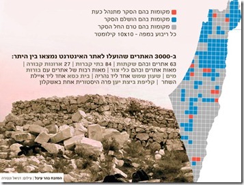
The Hebrew version of the article has several illustrations, and Joseph Lauer has provided the legend for the survey map:
Red- Active survey sites
Blue – Completed survey sites
Grey – As-yet unsurveyed sites
Each square on the map – 10 x 10 kilometers
The IAA website has more details about the survey’s progress and goals. The online database with the 3,000 sites is available here.
I recently compiled, with the help of some friends, a preliminary bibliography of archaeological surveys of Israel and Jordan published in the last few decades. If you know of any additional works, please let me know and I will update the list. The Hebrew publications for the regional surveys are given here.
