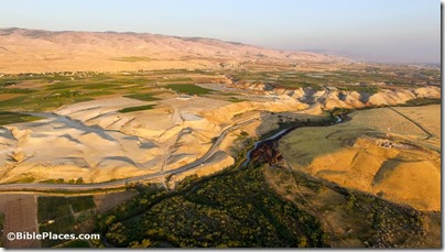
I had the opportunity to read a pre-publication draft of an article that David Z. Moster has written on crossing the Jordan River in antiquity. I found it a fascinating study, and I asked him if I could share some of his excellent research with you, and he kindly agreed.
1. The annual flow of the Jordan River today is 2% of what it was 60 years ago, before a number of major dams were constructed.
2. In the biblical period, the Jordan River was shallow and easy to cross in the north, and deep and difficult to cross in the south.
3. When William F. Lynch sailed down the Jordan in 1847, the depth at the Sea of Galilee was 2.5
feet deep and 7 feet deep at the Jabbok River.
4. In 1854 an expert swimmer was unable to make it across the river near Jericho because the river was too wide and the current too strong.
5. The PEF identified 41 fords between the Sea of Galilee and the Jabbok River but only 5 fords between the Jabbok and the Dead Sea.
- The greatest density of fords in the north was in the vicinity of Beth Shean where 15 were found in one 3-mile (5 km) stretch.
- All five fords in the south were near Jericho.
6. Before the Roman period, the only way to cross the Jordan was by fording. In later periods, bridges and ferries were built.
7. The only tribe to span the Jordan River was Manasseh, and that was in the northern section, a fact which corresponds with the topography noted above.
The article will be published as “Crossing the Jordan River during the Biblical Period: North vs. South” in the upcoming ARAM Periodical 29 (2017) entitled “The Jordan River.” David Moster’s research is available on Academia and he blogs at The 929 Chapters. Thanks to David to sharing his work with us!


3 thoughts on “Seven Fascinating Facts about Crossing the Jordan River”
What does PEF stand for?
Palestine Exploration Fund
Points 3 and 4 would be more helpful, if it were recorded what month of the year for both, and for point 4 the actual width of the spot that the swimmer attempted it… if this information is known. Thanks, Robert