In a nutshell, Ancient Jerusalem Revealed: Archaeological Discoveries, 1998-2018 is a summation of the results of a couple dozen excavations all over Jerusalem. Each article is written by the excavator(s), with the result that you feel like you’re standing at the site, getting the final synopsis of what they discovered. The volume is loaded with photographs and diagrams.

My intention is to summarize a few of these articles in upcoming posts. There are four articles from the “Old Testament” period (Bronze and Iron Ages), and today’s post is about the first one.

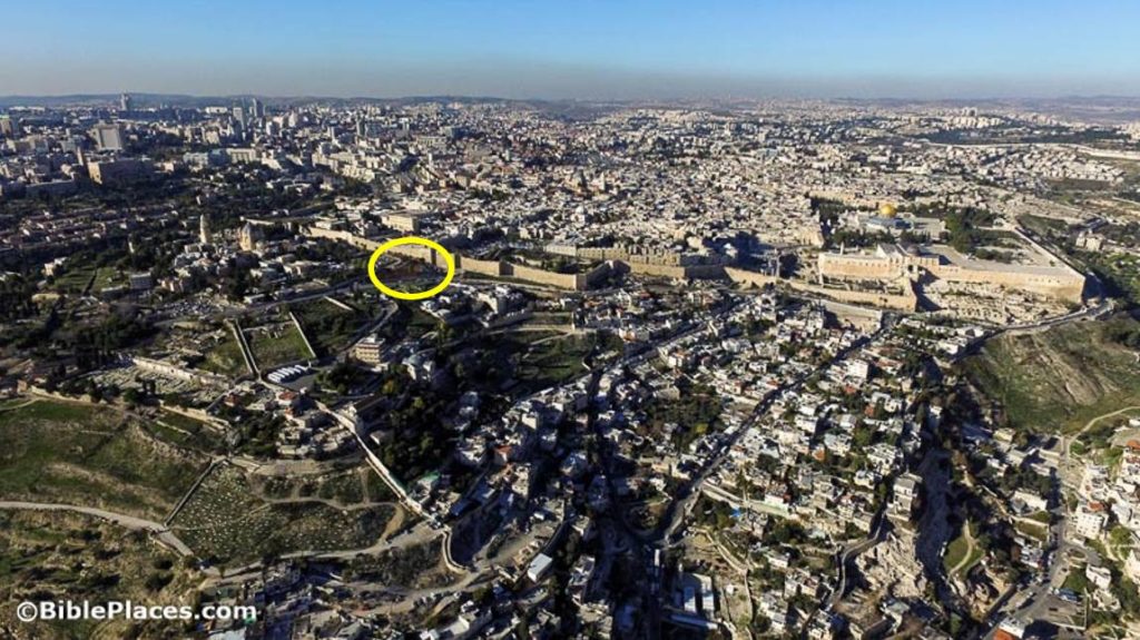
Ronny Reich and Eli Shukron excavated in the City of David for 14 years (1995-2008), and their chapter on “Recent Discoveries in the City of David” focuses on two subjects: (1) the rock-cut pool and (2) the Gihon Spring fortifications. Both of these are in close proximity to each other, and both of them have proven quite difficult to understand.

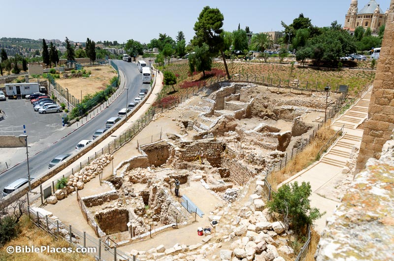
The Rock-Cut Pool was not a pool, but its walls chiseled into the bedrock at a height of [oops – the article doesn’t even say; I’ll guess 20 feet] are amazing. But holes in the bedrock, even really large ones, do not tell stories, and so the excavators focus all of their attention on what they found inside the “pool,” which necessarily dates to a period later than the “pool’s” earliest use.

What did they find inside the pool? (1) Lots of pottery, mostly from around 825-750 BC, which was tossed in from the surrounding area when someone built (2) a house. Yes, this seems like a strange place to build a house, but someone did. The excavators compared it to the house of Ahiel in Area G.

(3) Fish bones. A lot of fish bones. And strangely enough, this is the only place in Jerusalem where they have found lots of fish bones. Of the 10,600 fish bones, they identified 14 different fish families, but the favorites on Jerusalem dining tables were Sparidae (porgies) and Mugilidae (mullets). All of these were obviously imported, and a study of their size indicates that only small fish were transported, possibly because of the need to package them for transport up into the hill country by donkey.

(4) About ten seals and scarabs as well as fragments of more than 170 seal impressions. Because they were from an earlier period than the collection found in Area G, they did not have inscriptions in any Semitic languages. A few had Egyptian inscriptions. And there were some cool decorations such as boats, fish, sphinxes, and palmettes. The archaeologists believe that an administrative center existed near the Rock-Cut Pool. (5) An ivory pomegranate with a dove perched on top.

The archaeologists believe that these finds point to ties with Phoenicia, a proposal which corresponds with the presence of Queen Athaliah (the daughter of a Phoenician princess). The article only hints at the possibilities here, but the date seems to line up.

The second major subject of the article is the Gihon Spring fortifications. The main point of this discussion is that the Pool Tower is not a tower but a fortified passageway. Now this passageway is very impressive, with its northern wall preserved to a height of 25 feet! They traced the parallel walls for 75 feet before they had to stop because of modern obstructions. The problem is that the excavators cannot figure out what this (obviously expensive) fortification did, and they seem to conclude that it went out of use before it came into use, being replaced by a subterranean equivalent known as “Warren’s Shaft.” All of this they date to the Middle Bronze Age.

The authors are honest, and I appreciate that. Here’s a sample paragraph that reflects their wrestling with the difficulties:

The key question is: How did those drawing water reach the place above the northeastern corner of the Rock-Cut Pool? Did they descend from the city between the two parallel walls, or perhaps through the subterranean tunnel (of the Warren’s Shaft complex), to emerge from it at the eastern end of those two walls, and then turn south toward the deepest part of the Rock-Cut Pool? Were these routes perhaps in use at different periods of time? We have no stratigraphic data that might point to such a sequence of phases of use and they should, therefore be interpreted based upon contemporary logic.

I’m not too impressed with the use of logic in archaeological interpretation, but it’s nice that they don’t pretend that they have evidence that they don’t.

I’ll conclude where they conclude, with what I see as an astonishing admission of our lack of knowledge about the most basic question of them all: where was the city of Jerusalem at this time?

Answer: the city may have been north of these fortifications. Or it may have been south. The fortified passageway may be in the southeastern corner of the fortified urban area, or it may have been in the northeastern corner. I guess I’m just glad that the Kidron Valley is on the east side of their excavation, or we probably wouldn’t even know if this was the eastern or western side of the city!

If you like a little bit more certainty (or a lot!) in your archaeology, check back next week for my summary of Eilat Mazar’s excavation of the palace of David.

Share:

An inscription on an altar pedestal from the temple in Ataroth provides evidence for the Moabite conquest of the city. Christopher Rollston wrote more technical preliminary account in 2013. A journal article was published about the altar and another about the temple in the current issue of Levant.

“Archaeologists have discovered two ancient, unlooted chamber tombs dating from the Late Mycenaean period, (1400 – 1200 BC), near Nemea in the Peloponnesian Peninsula.”

“Located about 560 kilometers northwest of Cairo, Siwa Oasis is home to one of the most important burial sites dating to Dynasty 26, ‘The Mountain of the Dead.’”

The Tunisian government is bulldozing houses built over archaeological remains of Carthage, lest it lose its World Heritage status.

Ancient pottery is valuable for many things, including the preservation of the potter’s fingerprints.

Can you think of “three things in Susa that Esther likely saw”?

Wayne Stiles looks at the relationship between rain and the prayer of the righteous.

The Institute of Biblical Culture has some new courses lined up for the fall, and you can receive a 20% discount with the code “photos.”

The Albright Institute will be providing up to $200,000 in fellowships and awards for next year.

Mathematicians, have you heard of the “Josephus problem”?

HT: Agade, Alexander Schick, Joseph Lauer

Share:

Writing for Christianity Today, Steven Notley provides the background and evidence for identifying el-Araj as the New Testament city of Bethsaida.

Sergio and Rhoda have released a new video about Bethsaida and “The Church of the Apostles in Galilee.”

A mosaic floor in a church at Hippos apparently depicts Jesus’s multiplication of the fish and loaves (Haaretz premium).

NPR: Here’s what tourists might see if they were allowed to visit Gaza…


Smithsonian Magazine: Two tour guides—one Israel, one Palestinian—offer a new way to see the Holy Land.

The first post in Ferrell Jenkins’s new series “Agreement of Book and Land” is from Psalm 1:1-3.

Israel’s Good Name made a couple of evening trips to the Rishon LeZion sand dunes where he found gazelle, scorpions, and vipers.

New from DeGruyter: The Late Bronze and Early Iron Ages of Southern Canaan, edited by A. M. Maeir, Itzhaq Shai, and Chris McKinny.

The grandma whose congresswoman granddaughter refused to visit lives in the town once known as Upper Beth Horon.

HT: Agade, Tom Powers, Lois Tverberg

Share:

If you needed a quick summary of information about En-Gedi, where would you go? I’m doing research for an essay in a future volume of the Lexham Geographic Commentary series and this morning I was studying En Gedi in relation to David’s flight from Saul. I went through a dozen commentaries and pulled out various tidbits about David’s time in the area. Then I went to my standard Bible dictionaries. I usually consider Anchor Bible Dictionary to be the best, and so I started there. The article was decent. Then I went to others to see what else they had (ISBE, NIDB, EBD).

I recently pulled into my line-up the Lexham Bible Dictionary. I’ve been a bit skeptical of its value because it’s not a printed work and they used a wide variety of writers (including many students). But when I pulled up the LBD entry on En-Gedi I was immediately impressed. It was much longer and more thorough than the others. In fact, I think its length is probably twice that of the other four combined. That means there are separate sections on En-Gedi in Ancient Accounts (subdivided into biblical and extrabiblical), Geography and Geology (no one else has much on this), and Archaeological Investigations (which is subdivided into many sections). Then it closes with a bibliography, which is easily better than any I’ve seen elsewhere.

A final delight was to discover the author: Christian Locatell. I know this guy! He’s one of our ace creators of the Photo Companion of the Bible! (Many years before that, he was my student and he gave me various nicknames, but we won’t get into that…) He made a big contribution to our Acts volume, and his work on Romans has been spectacular! (That volume should be available in November.) So I figured I would write a little blogpost with three purposes: (1) to share some interesting tidbits about En-Gedi that you may not know; (2) to suggest you include the Lexham Bible Dictionary as part of your Bible study tools; and (3) to let you know that the author of this terrific article is creating more amazing resources for BiblePlaces followers. 🙂

Here are five ten interesting observations about En-Gedi from Dr. Locatell’s article:

1. Edward Robinson was the first modern explorer to identify En Gedi, and he did so on the basis of its Arabic name: Ain Jiddi.

2. David hid from Saul in the “strongholds” of En-Gedi (1 Sam 23:29), but when he wrote a psalm praising God for saving him from Saul, he called God his “stronghold” (2 Sam 22:2; Ps 18:2).

3. En-Gedi is believed to be the home of the Essenes (and not Qumran) by some scholars.

4. 700 inhabitants of En-Gedi were slaughtered by the Sicarii in the First Jewish Revolt.

5. Many ancient accounts rave about En-Gedi’s lush fertility.

[In one paragraph, Locatell quotes Karmon, Baly, and Efrat and Orni! I don’t think I’ve ever seen such geographical richness in one place. It’s a great paragraph, but too long to copy here. I am certainly proud to be this guy’s first geography teacher.]

6. Clouds over En-Gedi are rare, and the flash floods in the area are the result of the top rock layers being unable to absorb much of rainfall.

7. Most of the springs along the western shore of the Dead Sea have a high saline content, making En-Gedi such a precious resource of sweet water.

8. Between 1949 and 1972, there were seven archaeological expeditions to En-Gedi. [I had no idea there were that many.]

9. An Aramaic mosaic from the 5th-century AD synagogue refers to the “secrets of the town.”

10. Excavations on the northern slope of the tell revealed workshops and equipment probably used for producing the perfumes for which En-Gedi was famous.

There you have it. This is the best article on En-Gedi I know of. Thanks to Lexham and to Locatell for serving us so well.

BTW, we have some great photos of En-Gedi in our Judah and the Dead Sea volume.

Share:

Excavations under a house in northern Israel have revealed what may be the largest wine factory from the Crusader era.

Archaeologists have discovered an arrowhead from the Roman siege of Jotapata in AD 67.

A i24News video shows the “pilgrim road” leading from the Pool of Siloam to the Temple Mount of Jerusalem.

“Archaeologists working in the buried Roman city of Pompeii say they have uncovered a ‘sorcerer’s treasure trove’ of artefacts, including good-luck charms, mirrors and glass beads.”

A new exhibit about a 4th-century synagogue mosaic floor has opened in the Archaeological Museum of Aegina. Aegina is a Greek island not far from Athens.

“Anchors Aweigh: Seaports of the Holy Land” is a new exhibit opening on Tuesday at the Bible Lands Museum in Jerusalem.

Preliminary images of seven (alleged) Dead Sea Scroll fragments owned by the Southwestern Baptist Theological Seminary are now online. (The link looks unusual, but it works.)

Lubna Omar provides a personal perspective as a Syrian archaeologist unable to protect her country’s heritage.

A guy passionate about ancient Egypt and baking used ancient yeast to bake a loaf of bread.

Egyptian authorities transferred a 90-ton obelisk of Ramses II from Zamalek to El Alamein.

The Oriental Institute is celebrating its 100th anniversary.

Carl Rasmussen shares photos of the largest altar in the world.

I always like the photos that Wayne Stiles includes with his posts, and this week is no different with his reflections on Abraham’s faith.

Matti Friedman writes a helpful review of Jodi Magness’s new book on Masada.

Did you know there are four long distance hiking trails in Israel? They range in length from 37 miles to 637 miles.

HT: Agade, Joseph Lauer, Alexander Schick, Ted Weis

Share:

Archaeologists excavating on the Western Hill of Jerusalem (aka the modern “Mount Zion”) have announced the discovery of a destruction layer from the Babylonian conquest of Jerusalem in 586 BC.

The discovery is of a deposit including layers of ash, arrowheads dating from the period, as well as Iron Age potsherds, lamps and a significant piece of period jewelry – a gold and silver tassel or earring.

Despite what you might expect, archaeologists working in Jerusalem over the years have not found an abundance of material from this destruction, probably because it has been disturbed by later inhabitation. Shimon Gibson and his team date this material to the Babylonian destruction on the basis of context.

The team believes that the newly-found deposit can be dated to the specific event of the conquest because of the unique mix of artifacts and materials found — pottery and lamps, side-by-side with evidence of the Babylonian siege represented by burnt wood and ashes, and a number of Scythian-type bronze and iron arrowheads which are typical of that period.

The arrowheads are similar to those discovered at the “Israelite Tower” on the north side of ancient Jerusalem in a destruction context from the Babylonian invasion. Because the excavation site is inside the city walls, it is unlikely to be a dumping area.

“It’s the kind of jumble that you would expect to find in a ruined household following a raid or battle,” Gibson said. “Household objects, lamps, broken bits from pottery which had been overturned and shattered… and arrowheads and a piece of jewelry which might have been lost and buried in the destruction.”

“Frankly, jewelry is a rare find at conflict sites, because this is exactly the sort of thing that attackers will loot and later melt down.”

“I like to think that we are excavating inside one of the ‘Great Man’s houses’ mentioned in the second book of Kings 25:9,” Gibson speculated. “This spot would have been at an ideal location, situated as it is close to the western summit of the city with a good view overlooking Solomon’s Temple and Mount Moriah to the north-east. We have high expectations of finding much more of the Iron Age city in future seasons of work.”

The full press release is here, and the story is reported by numerous outlets, including The Jerusalem Post, The Times of Israel, and Haaretz (premium).

Jerusalem from the south, with excavation area circled


Area of Mount Zion excavations (in 2016)

Share: