Now online: Secrets of the Bible: The Fall of Jericho with Dr. Bryant Wood. (55 min)

Malerie Yolen-Cohen suggests 11 things to do in Israel that you may not have considered before.

The Holy Land Magazine is directed towards Christian tourists to Israel.

Ferrell Jenkins writes about Solomon’s Quarries in Jerusalem and the American missionary who discovered them in the 19th century.

Jenkins also shares a great quote from André Parrot who writes that “knowledge gained from books is certainly not enough, for names which are not attached to any reality are nothing more than ghosts.” Read the whole paragraph (and then book your next trip, or start a fund for your grandkid).

Turkish authorities are trying to figure out how to increase religious tourism to the site of ancient Ephesus.


The LA Times provides some background on the making of the Jerusalem 3D IMAX movie.

“The Siege of Masada” premieres on March 27 on the Smithsonian Channel. The one-hour special examines the evidence behind Josephus’ account.

Gerald McDermott addresses the question of whether the land of Israel should still be significant for Christians in a chapel message DTS.

HT: Agade, Jay Baggett, Ted Weis, Charles Savelle, Wayne Stiles

Share:

Iraq’s government reports that ISIS has bulldozed ancient Calah (modern Nimrud).

In light of ISIS’s recent destruction of Mosul, Iraq is vowing to protect ancient Babylon.

The Oriental Institute of the University of Chicago has issued a statement.

Citizens of Iraq and Syria are working to protect their historic treasures from destruction by ISIS.

A project has begun to “use crowd-sourced imagery to digitally reconstruct the heritage that has been destroyed.”

Daniel Pipes argues that “the ISIS record fits into an old and common pattern of destruction of historical artifacts by Muslims.”

The U.S. government has returned more than 60 artifacts illegally smuggled out of Iraq, including the head of an Assyrian lamassu from the palace of Sargon II.

Egypt will no longer grant visas to individual tourists upon arrival. You will need to apply in advance from an Egyptian embassy. Or travel instead to Israel, Jordan, Turkey, or Greece.

The Associates for Biblical Research has just released a new video, Digging Up the Sin Cities of Sodom and Gomorrah.

How was Trajan’s Column in Rome constructed? National Geographic features a stop-motion video that suggests an method. It is quite an extraordinary accomplishment.

We’ll have more links tomorrow.

HT: Agade, Charles Savelle

Share:

A large bronze mask depicting the god Pan was excavated at Hippos (Sussita). A video shows the discovery with the use of a metal detector. A press release from the University of Haifa has more details.

Members of the Israeli Caving Club discovered a cache of rare coins and other artifacts from the
Hellenistic period in northern Israel. That find is one of seven exciting discoveries made around the world this month.

An orange gem depicting the goddess Artemis has been discovered at the Herodium.

Luke Chandler reports that inscriptions from Khirbet Qeiyafa and Tel Lachish will be published soon.

A man walking on the beach at Ashkelon found some archaeological pieces.

Leen and Kathleen Ritmeyer’s guide to the Temple Mount has been published. Copies may be purchased from their website.

Clint Gilbert has recorded a Bible Lands Song which can help you or your students learn basic Bible geography.

Studies suggest that ancient people didn’t perceive the color blue because they didn’t have a word for it.

AWOL’s List of Open Access Journals in Ancient Studies now includes 1481 titles.

Sad news: Harry A. Hoffner passed away suddenly on Tuesday, March 10. Hoffner was a long-time professor of Hittitology at the University of Chicago’s Oriental Institute. I am told that his two-volume commentary on 1-2 Samuel for the Evangelical Exegetical Commentary was recently submitted to the editor.

More sad news: “Hans G. Goedicke, a renowned Egyptologist who had been chairman of the Johns
Hopkins University’s department of Near Eastern studies, died of cancer Feb. 24.”

We’ll have more links tomorrow.

HT: Agade, Charles Savelle, Bill Schlegel, Joseph Lauer

Share:

The 26-mile race to be held on April 9 follows the path of the Benjamite who ran to tell Eli of the capture of the Ark of the Covenant (1 Samuel 4). From the official website:

One of the first runs recorded in human history—long before the “marathon” told of in Greek mythology—is mentioned in the Bible, in the beginning of the book of Samuel. At the end of the war between the Israelites and the Philistines, the “man of Benjamin” runs from the battlefield at Eben Ezer (modern day Rosh Ha’ayin) to Shiloh, city of the shrine. His runner’s mission is to inform Eli the priest of Israel’s defeat in this war, the falling of his sons, and the capture of the Ark of the Covenant.
Many centuries later, after the Six Day War, the founder of the Maccabiah games, Yosef Yekutieli, set out to measure the length of the course from Rosh Ha’ayin to Shiloh, in the Benjamin region. He was amazed to find that the length of this historic path precisely matched that of the modern marathon – 42 kilometers (the official length of the Olympic running contest, determined in 1908 at the London Olympics). In the 1970s, Yekutieli initiated various marathons in the wake of the Biblical “man of Benjamin”. It is truly amazing, the thought that if only someone had informed the Baron de Coubertin, founder of the 42 km Olympic run, of the Biblical story, then perhaps instead of “marathon” it would be called one of the following: Shiloh Race, Man of Benjamin, or Bible Race.

More details here.

Shiloh aerial from east, bb00120068
Shiloh aerial from the east
Photo by Barry Beitzel, available in the Pictorial Library of Bible Lands
Share:

Accordance Bible Software has just released two photo collections created by BiblePlaces.com and both are on sale through Monday for 25% off.
Cultural Images of the Holy Land features more than 1,000 photos of the grain harvest, grape harvest, olive harvest, plowing, shepherds, sheepshearing, watchtowers, wells, cisterns, pottery making, Samaritan Passover, Jewish holidays, Christian holidays, weddings, scribes, Bedouin tents, and a host of other animals as well. Through March 23, 2015 you can get this photo collection for $29.90, which is 25% off the regular price of $39.90.


Trees, Plants, and Flowers of the Holy Land includes over 1,500 high-resolution photos of trees, crops, herbs, shrubs, plants, thorns, drugs, spices, incense, perfume, and more and is carefully organized and documented with Scripture references. The sale price is also $29.90.

You can read more about the value of these collections and view sample images and screenshots at the Accordance website.

“I am thrilled to see Todd Bolen’s work come to Accordance. I have owned and used the Pictorial Library of the Bible Lands for years. I highly recommend these!” — Tony Lawrence, Accordance User

Share:
(by Chris McKinny)


In past years, this blog has
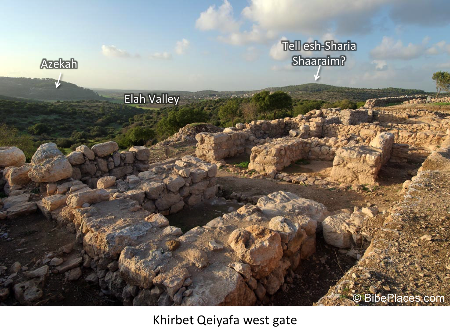
discussed extensively
the identification of Khirbet Qeiyafa, which has been
identified with Shaaraim by the excavators. I agree that Khirbet Qeiyafa should
not be identified with Shaaraim (see also below), but if Khirbet Qeiyafa is not
Shaaraim then where should we locate the biblical town?
  
Shaaraim is mentioned twice in the
biblical narrative, once in the Eshtaol district (Josh. 15:36, cf. Onom. 87.1) where
it is found between and again in association with the Philistine retreat
following the death of Goliath (1 Sam. 17:52). The text states that they fled
“as far as Gath and up to the gates of Ekron…on the way of Shaaraim, as far as
Gath and Ekron.” This latter context clearly puts the site in the vicinity of
the battle, which occurred in the Elah Valley between “Socoh and Azekah at
Ephes Dammim” (1 Sam. 17:1). Also, it should be noted that this reference does
not actually refer to the town of Shaaraim, but to the road that led to Gath
(Tell es-Safi) and Ekron (Khirbet el-Muqqana). Therefore, the text seems to
indicate that Shaaraim should be located west and perhaps north of the battle
with the toponym likely deriving from the routes that went through the Elah and
Sorek Valleys to Philistine Gath and Ekron (Na’aman
2008b:2–3).


Click on sites to see archaeological details and pictures


Garfinkel and Sanor, the excavators
of the recently concluded excavations at Khirbet Qeiyafa (2012), have revealed
one of the more intriguing ancient sites from the Early Iron Age IIA (i.e. 10th
century BCE). They have identified
Khirbet Qeiyafa with Shaaraim. This argument is based on three main criteria:
1) Shaaraim occurs after Socoh and Azekah in Joshua 15:35-36, 2) the site is
located directly above the presumed location of the biblical battle between
David and Goliath, and 3) the site produced two Iron IIA four-chambered gates
inside of a massive casemate fortification, which gave the name to the site
(Shaaraim = two gates) (Garfinkel and Ganor
2008; Adams 2009:47–66).
This identification has received a good deal of criticism from various scholars
who have offered different identifications for Khirbet Qeiyafa (Na’aman 2008a
  Gob, before changing his mind in,
2012:88; see also Finkelstein and Fantalkin 2012:48; Galil 2009 – Netaim; Levin
2012b –  Ma’agal – interpreted as a
circular military fortress mentioned in 1 Sam. 17:20; Bolen 2012 –  Ephes Dammim, but it is possible that this is a
regional term).
Simply stated, Khirbet Qeiyafa should not be identified with Shaaraim. This is
due to the fact that the dual ending most likely does not mean “two gates” and
the site should be located further to the west/northwest (Na’aman
2008b:3–4; see also Elitzur 2004:282–290). This latter point means that
Rainey’s earlier identification with Khirbet es-Saireh can probably be ruled out on
geographical grounds (see discussion in 1975:69*; but see his later opinion that left Shaaraim unidentified 2006:147). On the other hand, Dagan’s suggestion of Khirbet
esh-Sharia, which is situated between Azekah and Khirbet el-Kheisum
(Adithaim?), would seem to fit this geographical requirement (1996a:139). Additionally, Khirbet
esh-Sharia would seem to present a compelling toponymic connection with
Shaaraim. The archaeological remains at the site are also in line with this
identification, as the site has remains from the Iron IIA (30 dunams**), Iron
IIB-C (40 dunams), and
Roman-Byzantine periods (Zissu
2000:77*–78*; Dagan 2000:site 55).


I disagree with Na’aman’s
conclusion that Khirbet esh-Sharia is not far enough to the west to match the
retreat of the Philistines (1 Sam. 17:52) (2008b:4–5). There are no known Judahite
sites to the west of Azekah (i.e. between Azekah and Philistine Gath) and it
seems that the Azekah-Tell Judeidah ridge formed a clear topographical border
between Philistine Gath and Judah (1983:10–11). Khirbet esh-Sharia sits very
near both the Elah Valley route to Gath and Ekron (Dorsey 1991:J6) and the “Diagonal Route” that
connects the Elah and Sorek Valley systems (Dorsey 1991:Sh2). In light of Na’aman’s
contention that Shaaraim was the “gateway to Judah” (2008b:4–5), it is difficult to
understand his hesitation to identify a site that perfectly suits his
definition.

** 1 Dunam = 1000 square meters

Update: Rainey references updated. 


Bibliography (note links to available online PDFs)

Adams, D.L.
            2009  Between Socoh and Azekah: the Role of the
Elah Valley in Biblical History and the Identification of Khirbet Qeiyafa. In Khirbet
Qeiyafa Vol. 1, Excavation Report 2007–2008
, edited by Y. Garfinkel and S.
Ganor, pp. 47–66. Israel Exploration Socity, Jerusalem.

Bolen, T.
            2012  Pictorial Library of Bible Lands.
BiblePlaces.

Dagan, Y.
            1996  Cities of the Judean Shephelah and Their
Division into Districts Based on Joshua 16. Eretz Israel 25: 136–46,
92*.
            2000  The Settlement in the Judean Shephelah in the
Second and First Millennium BC: A Test Case of Settlement Processes in a
Geographical Region. Unpublished Ph.D. Dissertation, Tel Aviv University, Tel
Aviv.

Dorsey, D.A.
            1991  The Roads and Highways of Ancient Israel.
The Johns Hopkins University, Baltimore and London.

Elitzur, Y.
            2004  Ancient Place Names in the Holy Land:
Preservation and History
. Hebrew University and Magnes Press and
Eisenbrauns, Jerusalem and Winona Lake.

Finkelstein, I., and A. Fantalkin
            2012  Khirbet Qeiyafa: An UnsensationalArchaeological and Historical Interpretation. Tel Aviv 39(1): 38–63.

Galil, G.
            2009  The Hebrew Inscription from Khirbet
Qeiyafa/Neta’im: script, language, literature and history. Ugarit-Forschungen(41):
193–242.

Garfinkel, Y., and S. Ganor
            2008  Khirbet Qeiyafa: Sha`arayimn. Journal of
Hebrew Scriptures
8(0).

Levin, Y.
            2012  The Identification of Khirbet Qeiyafa: A NewSuggestion. Bulletin of the American Schools of Oriental Research(367):
73–86.

Na’aman, N.
            2008a  In Search of the Ancient Name of KhirbetQeiyafa. Journal of Hebrew Scriptures 8(21): 2–8.
            2008b  Shaaraim – The Gateway To The Kingdom OfJudah. Journal of Hebrew Scriptures 8: 2–5.
            2012  Khirbet Qeiyafa and the Philistine- Canaanite
Struggle in South Canaan in the Early Iron Age. Cathedra 143: 65–92.
Rainey, A.F.
           1975  The Identification of Philistine Gath. A Problem in Source Analysis for Historical Geography. Eretz Israel 12: 63*–76*.           
           1983  The Biblical Shephelah of Judah. Bulletin
of the American Schools of Oriental Research
(251): 1–22.

Zissu, B.
            2000  Khirbet esh-Shari’a. Hadashot
Arkheologiyot: Excavations and Surveys in Israel
111: 77*–78*.
Share: