(Post by Seth M. Rodriquez)

You can have Athens . . . I’ll take Corinth.

As I prepared to write another post on a site in Greece, I was drawn once again to Corinth. It is such a fascinating site in so many different ways: archaeologically, geographically, and biblically. After searching around for another site to write about (for the sake of variety) I’m throwing in the towel . . . Our picture of the week comes from Volume 11 of the Pictorial Library of Bible Lands and focuses once again on Corinth.

The picture below is entitled “Corinth bema and Acrocorinth.” The Acrocorinth is the tall mountain that rises in the distance. The bema (also called the “tribunal” or “judicial bench”) is the structure in the left half of the picture. It was a platform on which a judge would sit as the people brought their cases before him while standing in the plaza below. This is one of those rare places where we can say that a certain biblical event took place. This place of judgment is mentioned in Acts 18, when Paul was brought before Gallio.

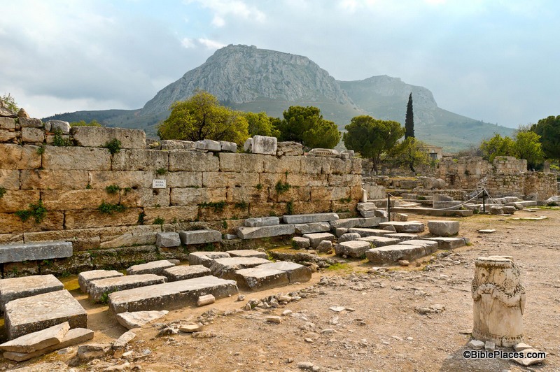
But when Gallio was proconsul of Achaia, the Jews made a united attack on Paul and brought him before the tribunal, saying, “This man is persuading people to worship God contrary to the law.” But when Paul was about to open his mouth, Gallio said to the Jews, “If it were a matter of wrongdoing or vicious crime, O Jews, I would have reason to accept your complaint. But since it is a matter of questions about words and names and your own law, see to it yourselves. I refuse to be a judge of these things.” And he drove them from the tribunal. And they all seized Sosthenes, the ruler of the synagogue, and beat him in front of the tribunal. But Gallio paid no attention to any of this. (Acts 18:12-17, ESV)

The PowerPoint® notes in the PLBL provides the following background information:

The Roman tribunal where Paul was dragged before Gallio has been uncovered in the center of the agora. This was the bema, where Roman officials would appear before the public…. Had Paul’s trial been more formal, it likely would have been held at the North Basilica instead of the Bema. In Christian times, a church was built atop the bema.

So we know where this trial (or would-be trial) took place, but the story doesn’t stop there. F. F. Bruce in his book, New Testament History, points out that this trial had particular significance in Paul’s ministry:

Sir William Ramsay regarded Gallio’s ruling as ‘the crowning fact in determining Paul’s line of conduct’, because it provided a precedent for other magistrates, and thus guaranteed Paul’s freedom to prosecute his apostolic mission with the assurance of the benevolent neutrality of the imperial authorities for several years to come. One thing at least is certain: if Gallio had given an adverse verdict against Paul, it would have been pleaded as a precedent by Paul’s opponents for the rest of his life; and a precedent established by so exalted and influential a magistrate as Gallio—a much more important personage than the politarchs of Thessalonica—would have carried great weight.  The mere fact that Gallio refused to take up the case against Paul may reasonably be held to have facilitated the spread of Christianity during the last years of Claudius and the earlier years of his successor.

Thus, this site can not only be tied to a biblical event, but it can be tied to a biblical event that is more significant than can be observed at first glance. The event that happened in this humble location helped determine how the rest of New Testament history played out.

This photo and over 800 others are available in Volume 11 of the Pictorial Library of Bible Lands and is available here for $34 (with free shipping). Other photos of Corinth and its surrounding territory can be found on the BiblePlaces website here and here. The excerpt was taken from F. F. Bruce, New Testament History (Garden City, NY: Anchor Books, Doubleday & Company, 1969), p. 317, and is available for purchase here.

Share:
(Guest post by A.D. Riddle)

Unlike its neighbor to the south, Lebanon has only a handful of excavations currently in progress and there is no systematic archaeological survey of the entire country presently available. Sadly, archaeological work is only being carried out at a total of five (or so) sites: Sidon, Tell Arqa, Tell el-Burak (link 2, link 3), Baalbek, and Kamid el-Loz.

Tell Arqa in northern Lebanon.

Naturally, one would think that the paucity of archaeological work (and tourism, for that matter) is due to present security conditions. But that is only part of the story. Hélène Sader, a historian and archaeologist at the American University in Beirut, has written a piece for the ASOR blog entitled, “Archaeology in Lebanon Today: Its Politics and Its Problems,” in which she paints a fairly bleak portrait of the current situation.

The outdated antiquities law which established the Lebanese Directorate General of Antiquities (DGA) “as the sole authority” limits the DGA’s staff “to five archaeologists, five trainee archaeologists, and five architects in charge of regular and salvage excavations, restoration and conservation of historical and archaeological monuments, and the curatorship of the national and regional museums collections!” Following the Lebanese civil war (1975-1990), the Lebanese government set out to rebuild Beirut’s Central District. The DGA was then faced with the task of not only rebuilding the National Museum, but also “supervising the largest urban excavation site in the world with practically no qualified personnel, no funds, and no political support.” Since 2000, “the DGA has become extremely restrictive regarding long term excavation projects” and is “reluctant to issue permits to foreign institutions.” Numerous salvage excavations go unpublished and the excavated remains are “regularly bulldozed or disfigured by irresponsible urban planning without any objections.”
Sader concludes:

The DGA has been without leadership for the last four years. The last Director General resigned three years ago and the appointment of a new one is still blocked by political rivalries. The failure to build a new generation of professional and well-trained archaeologists is so dramatic that it is very hard today to find even a small pool of competent candidates for the position of Director General from within or outside the department of antiquities. Several DGA archaeologists and architects have lately resigned out of frustration and it seems that the institution is back to square one: no director general, insufficient numbers of qualified professionals, no reforms of the laws regulating archaeological work, no funds, and first and foremost, no vision and no direction for the future of archaeology in Lebanon.

We keep our fingers crossed that the future leadership of the DGA will have the political and financial support of the Lebanese government to build a modern institution and to promote archaeological research. Maybe then, like a phoenix, Lebanese Archaeology will rise from its ashes.

Share:

The site identified as the most eroded site in Israel is Tell Jemmeh, located on the bank of the Nahal Besor about 7 miles (12 km) due south of the city of Gaza. The site was identified as biblical Gerar by W. J. Phythian-Adams and Sir Flinders Petrie. Benjamin Mazar’s suggestion that Tell Jemmeh is Yurza is now commonly accepted. Yurza is mentioned in Egyptian and Assyrian texts but not in the Bible. The source of the quotation is the “Jemmeh, Tell” article by the late Gus W. Van Beek in The Anchor Bible Dictionary, volume 3, page 677.

We had a number of good responses in the comments yesterday, all of which show that there are many severely eroded tells in Israel. The correct answer was given by Dr. Carl Rasmussen, but if you’re feeling bad that you lost out, you can take comfort in the fact that you lost to someone who has written one of the best Bible atlases!

Tell Jemmeh side washed out by Nahal Besor, tb050701352
Tell Jemmeh, showing erosion caused by the Nahal Besor.
Photo from the Pictorial Library of Bible Lands,
volume 5
Share:

Can you identify this site?

“[The site] originally occupied a mesa encompassing an area of 4.92 hectares (12.15 acres). It is the most-eroded major site in Israel, the N end having been destroyed by flash floods in Nahal [X], and the S end by severe erosion. The area on the top of the mound is now reduced to 0.26 hectares (0.64 acres) from an estimated original area of 3.04 hectares (7.51 acres). The site is the highest point in the landscape, reaching a height of 22 m (71 feet) above present ground level. Its upper 15.50 m (50 feet) is occupation debris of successive towns.”

If you know the answer, you’re welcome to post it in the comments below. If you discover the answer by research, please do not post it in the comments below. I’ll post the answer, source of the quotation, and a photo tomorrow.

Share:

The best way to get up to speed on the major discoveries at Hazor from the Bronze Age is with Amnon Ben-Tor’s article on the ASOR Blog.

A brief report of the finds and surprises from the season at Gezer has been written by the excavators.

This year’s excavations of Gath are over, but Aren Maeir is making us wait for a summary of “one of the most productive, interesting and overall great seasons we have had since the project began (in 1996…).” Check out the rest of his blog for season-end photos.

Though most tourists skip Ashkelon, this Haaretz article reveals how the site is “a treasure full to bursting.”

I failed to note previously a couple of articles following up on the discovery of the “palace of David” at Khirbet Qeiyafa. A Baptist Press article provides some balanced coverage. And excavation volunteer Luke Chandler gives his personal perspective.

The theater in Assos is being renovated to accommodate events for up to 5,000 people.

Mark Wilson provides some background for 1 Corinthians 3:17 from the destruction of the Ephesian temple of Artemis.

The Oxford Encyclopedia of the Bible and Archaeology is now reduced to $235. It’s currently out of
stock, and I don’t know how long the discount will last. (This is an unusually large discount when compared with other Oxford sets such as OAENE, OEAGR, and OEBB.)

HT: Jack Sasson

Assos theater and acropolis from below, tb041605082
The theater and acropolis of Assos
Photo from the Pictorial Library of Bible Lands, Western Turkey
Share:

(Post by Seth M. Rodriquez)

In the 1970’s and 1980’s, the remains of several ancient harbors were identified around the Sea of Galilee. At least 13 harbors have been identified, all of which most likely date to the Hellenistic and Roman Periods. A map of the various harbors can be seen here. The work of archaeologists in this area (most notably, the labors of Mendel Nun) have provided us with significant insights into what life was like for fishermen who worked on the Sea of Galilee during these periods.

Our picture of the week comes from Volume 1 of the Pictorial Library of Bible Lands, and shows the remains of the main breakwater of the harbor of Susita (a.k.a., Hippos) on the southeastern shore of the Sea of Galilee. The photo was taken at a time when the water level in the lake was extremely low, so the breakwater stands several meters from the shore. However, in ancient times this breakwater would have provided boats with shelter from dangerous storms that can occur on the lake (for example, see Matt. 8:23-27).

This harbor was a typical one on the Sea of Galilee during this period. The breakwater was man-made and extended from the shore, enclosing an area of about an acre with a gap on the south end for boats to pass in and out.  In the map referenced above, the Hippos harbor can be seen at the bottom right.  Mendel Nun, in his book Ancient Anchorages and Harbours Around the Sea of Galilee (Kibbutz Ein Gev, Israel: Kinnereth Sailing Co., 1988), describes this harbor in the following way:

The harbour of Susita was built to fit the conditions of the sandy shore. The central breakwater is 120 meters long; its base is five to seven meters wide. The stone breakwater projecting from the shore turns to the south and runs nearly parallel to the shore at a depth of -211.25 meters [693 feet below sea level] for another 85 meters.

At the far end it curves sharply to the west and extends into the lake to a depth of -212.5 meters [697 feet below sea level]. This shape makes for a long inner area open to the south; a second breakwater was therefore constructed which extends from the shore for 40 meters. The inner part of the harbour thus formed a closed basin enclosing an area of about an acre. A small jetty leading north from the breakwater was for passengers embarking and disembarking, saving them the tedious procedure of passing through the narrow harbour entrance.  Indications that this entrance was deepended [sic.] may still be seen.

The total lenght [sic.] of all the breakwaters in this harbour comes to 180 meters.  The sides were built of rows of stones, the interstices filled with smaller rocks, re-used building stones, fragments of lime columns. During the past few years of low water, the silt filling the harbour has been overgrown by shrubbery.  (Nun, Ancient Anchorages and Harbours, pp. 13-14.)

Harbors such as this bear witness to the thriving economy around the lake during the time of Christ. Although people have probably always fished in the lake, the Roman Period was a time when fishermen were especially active and an unusually high number of settlements were constructed around the Sea of Galilee. According to Mendel Nun, “all settlements on the shores of the Sea of Galilee, even the smallest, had an anchorage, each built to suit local conditions and requirements.” (Ibid., p. 27.) So harbors such as this would have been part of the everyday life of people living next to the lake. Insights such as this add color to our reading of the stories in the Gospels.

This photograph and over 1,100 others are available in Volume 1 of the Pictorial Library of Bible Lands, and is available here for $39 (with free shipping).  Additional images of the Sea of Galilee can be found on the BiblePlaces website here and here, and on LifeintheHolyLand.com here.  Images and information about fishermen on the Sea of Galilee in the 19th century can be found here on LifeintheHolyLand.com.  Additional information about the ancient harbors around the Sea of Galilee can be found here.

Share: