This may be the most interesting archaeological excavation in the Old City of Jerusalem in the last few years. The Lutheran Church of the Redeemer is located next door to the Church of the Holy Sepulcher. From DW:

Two-thousand years of biblical history lay buried 14 meters beneath the Lutheran Church of the Redeemer in Jerusalem. German archeologist Dieter Vieweger led the excavation of the site.
A Herodian quarry, the remains of Golgotha, buildings from the period of the Roman Emperor Hadrian, mosaics from the Church of Saint Maria Latina: At the end of 2012, the Archaeological Park was opened under the Lutheran Church of the Redeemer in Jerusalem, giving visitors the chance to take a tour of these locations and understand the city’s colorful past. German archeologist Dieter Vieweger spent three years building the park together with a team of students and experts.
[…]
The archaeological park makes 2,000 years of history in Jerusalem visible – from Herod to the Crusaders to today. As a biblical archeologist, which chapter in history do you find most interesting?
For me, of course, the oldest layers are the most interesting – those buried 14 meters (46 feet) under the Church of the Redeemer. That’s where we found a stone quarry built by Herod the Great. You can actually walk around it and see how thick the stones were carved out, sawn and broken. The quarry was used to expand the city to the east of the site at Herod’s instruction. But not all of the stone was taken from the ground where the Church of the Redeemer now stands. This area was later called Golgotha, the location where Jesus was crucified. In this section of the archeological park, visitors come very close to Christian and Jewish history.

The full article is here. The site is now open to the public, but it closes early in the afternoon. In a post last year, Tom Powers wrote about his tour of the site before it opened.

German Church of the Redeemer, mat00862
Lutheran Church of the Redeemer, early 1900s
Photo from The American Colony and Eric Matson Collection
Share:

The Israel Museum’s largest and most expensive archaeological project will open on February 12 and run for nine months. From Phys.org:

Israel’s national museum said Tuesday it will open what it calls the world’s first exhibition devoted to the architectural legacy of biblical King Herod, the Jewish proxy monarch who ruled Jerusalem and the Holy Land under Roman occupation two millennia ago. The display includes the reconstructed tomb and sarcophagus of one of antiquity’s most notable and despised figures, curators say. […] Herod’s final grandiose project was to prepare for death. Curators believe Herod constructed an extravagant, 25-meter-high (80-foot-high) tomb. Israeli archaeologist Ehud Netzer spent 35 years of his career searching for it. In 2007, Netzer drew international attention when he announced he had found what he believed was the tomb at the Herodion, the ruler’s winter palace, located on a cone-like hill that still today juts out prominently in the barren landscape of the Judean Desert, near the West Bank city of Bethlehem. In 2008, the archaeologist approached the Israel Museum about creating an exhibit that would display artifacts from one of the greatest finds of his career. While surveying the Herodion site with museum staff, Netzer fell to his death. Museum staff pushed forward with planning the exhibit. In 2011, the museum used a crane to remove dozens of half-ton columns and the roof of what Netzer identified as the top floor of Herod’s tomb, which he thought held his sarcophagus. Each stone was affixed with an electronic chip so it could be more easily be put back together at the Israel Museum. Three sarcophagi were found at the site, and curators believe one was Herod’s. Though it bears no inscription, it is made of a special reddish stone, found smashed into hundreds of pieces. The Jewish zealots who took over the Herodion after Herod’s death likely smashed the sarcophagus to pieces, destroying the symbol of a man who worked with the empire they were rebelling against, curators said.

The full story is here. Barry Britnell also notes a 60-second promo video made by the Israel Museum. In related news, The Times of Israel reports:

As part of a new plan, a replica of his tomb at Herodium, situated outside the West Bank city of Bethlehem, will tower to 83 feet and will be visible from Jerusalem.

Herodium Herod's tomb, tb051708036 Remains of Herod’s tomb at the Herodium.
Photo from Judah and the Dead Sea.

Share:

The New York Times has a profile of the Carchemish excavations, including results from the first two
years. I particularly enjoyed Mr. Marchetti’s story of discovering an almost intact monolith lying on the surface on his first day on the site.

This Jerusalem Post article on Jesus and the Jordan River discusses both tourist sites on the northern and southern ends.

This Haaretz article on “Masada for runners” isn’t what I expected. (I wanted fastest times to the top; they tell you to run around the bottom.)

Google Street View now covers much of Israel, including “most of Israel’s large and medium sized towns, many villages in central Israel and the Galilee, and historical and tourist sites such as the Dead Sea, the coral reefs of Eilat, the Dead Sea, Megiddo, and many more.” It does not include Judea and Samaria.

“Museum staff in Manchester have devised a computer console which allows visitors to ‘handle’ ancient artefacts. The technology at Manchester Museum – the first of its kind in the UK – allows the public to virtually touch delicate objects which would normally be kept behind glass.”

Tyndale Tech has a great run-down of computer resources for Old Testament Studies.

HT: BibleX, Jack Sasson

Carchemish citadel and Euphrates River from north, adr1005191620
Carchemish citadel and Euphrates River from the north.
Photo from the fantastic Pictorial Library of Bible Lands.
Share:

Shmuel Browns has photos of the Dome of the Chain now that the metal sheeting for renovations has been removed.

Lois Tverberg (“Our Rabbi Jesus”) suggests resources to help you learn about the life of a shepherd. I particularly like her first and last recommendations.

Leen Ritmeyer reports on the upcoming move of the Temple Institute in the Old City of Jerusalem.

Exploring Bible Lands has a great photo of the Jerusalem model (at the Israel Museum) covered with snow. You might want to subscribe to this newer blog while you’re there.

To return to familiar subjects, Leen Ritmeyer has photos old and new of Jerusalem in the snow.

A new book by Baruch Sterman, The Rarest Blue tells the 4,000-year-long story of the biblical blue tekhelet. Last week it was awarded the Book Prize for 2013 by the Jewish Journal.

Shepherd with sheep near Sede Boqer, tb042007446
Shepherd with sheep in Negev Highlands
Photo from Cultural Images of the Holy Land
Share:

Horbat Hazzan and Horbat Avraq – A building from the late Iron Age was excavated along with several winepresses, columbaria, and a limekiln.

Jerusalem, Shuafat Ridge – Several miles north of ancient Jerusalem, archaeologists completed excavation of a farmhouse from the 8th-7th centuries BC.

Jerusalem, Qiryat Moriyya – Part of the low-level aqueduct that brought water to Jerusalem from Solomon’s Pools was exposed in Arnona.

Mount Tabor – An excavation near the Gate of the Winds revealed a portion of the Ayyubid fortification, built in 1212-1213 by the nephew of Saladin when the mountain was being contested by the Muslims and Crusaders.

Jaffa – Excavations of two areas in the modern flea market revealed a large pool “as well as pottery, glass vessels and coins dating to the Persian, Hellenistic, Late Roman, Byzantine, Early Islamic and
Crusader periods.”

iaa-columbarium-5723-8
Columbarium from area near Horbat Hazzan.
Photo by IAA.
Share:

(Post by Seth M. Rodriquez)

Why is it that the more important the biblical site, the more it tends to be surrounded by modern buildings?  Sites such as HazorMegiddo, and Gezer have a lower level of biblical significance (see 1 Kings 9:15) yet they are delightful places to visit because they are relatively untouched by modern developments.  But take a city like Jerusalem, Bethlehem, or Nazareth, and you need to hire a professional guide to help you find the ancient remains among the modern.

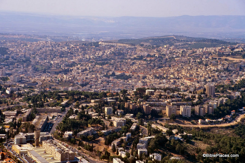
Take Nazareth for example.  I have been to Nazareth a number of times, but I have seen few (if any) ancient remains in that city.  It is completely covered by modern buildings.

Nazareth Today

This is not to criticize the modern inhabitants of the city.  They have a right to live there and build comfortable houses and reliable roads.  I am merely pointing out that often modern developments can diminish the usefulness of a location for teaching purposes.  This is why a site such as LifeInTheHolyLand.com and the resources available through that site are so helpful.

Our picture of the week comes from a book entitled Earthly Footsteps of the Man of Galilee, which has been reproduced in electronic form and is available through  LifeInTheHolyLand.com.  It contains nearly 400 photographs taken in 1894.  The book follows the life of Christ and the apostles chronologically, traveling back and forth through various countries.  Below is a picture entitled

“Nazareth from the East” and is followed by an excerpt from the book.  In this image, the city of Nazareth is much smaller than it is today.  The Nazareth of 1894 was probably much larger than the Nazareth of the 1st century, and yet this photograph provides a better impression of the Nazareth that Jesus knew than any modern photograph could hope to reproduce.
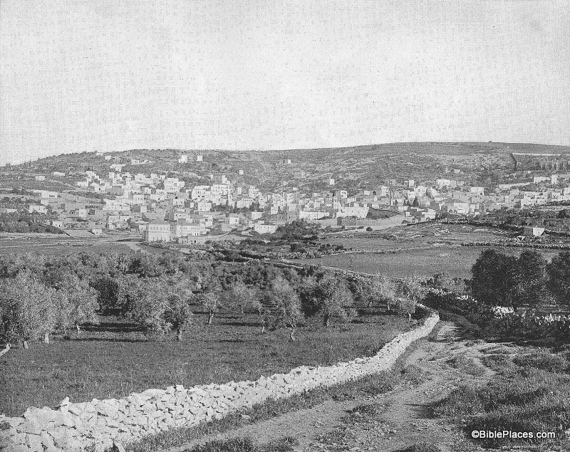
Nazareth in 1894

NAZARETH FROM THE EAST.–After an absence, according to Dr. Andrews, of something like six months, the Holy Family with the infant Jesus came in sight again of their own home.  If they approached the city from the East they would get the view, as far as the topographical features are concerned, given above.  Nazareth stands almost mid-way between the Jordan and the Mediterranean Sea, as we have already said.  It lies on the eastern slope of the hill, from the summit of which a magnificent prospect opens out.  Toward the north are the hills of Galilee and the majestic summits of the snow-crowned Hermon.  On the east is the Jordan valley and in dim outline the heights of the ancient Bashan.  To the south spreads the beautiful plain of Esdraelon, with Mount Tabor, Little Hermon and Gilboa; in sight, beyond, are the hills of Samaria, and on the west Carmel faces the blue waters of the Mediterranean.  No traveler should miss this view from the hill behind Nazareth.  It is perhaps the richest and most extensive in all Palestine.  The nearer hills are wooded, and drop in graceful slopes to broad and widening valleys of “living green.”  In the village below, upon this eastern slope, the Savior of the world passed his childhood.  His feet must frequently have wandered over these hills, and his eyes looked again and again from the summit as do the eyes of pilgrims now.  Here the Prince of Peace looked upon the great plain of Esdraelon, where had so often been heard the din of battle; and upon that sea over which the swift ships were to bear the tidings of his salvation to continents and nations then unknown.  The history of Nazareth seems to cluster about one remarkable event, “The Annunciation.”  Before that the place was unknown.  But to the Christian, Nazareth is the home of the Savior’s boyhood; the scene of his early labors, his prayers, his domestic relations, his whole private life for thirty years.  This gives unspeakable charm to the town.

Quote taken from John H. Vincent, James W. Lee, and R. E. M. Bain, Earthly Footsteps of the Man of Galilee (New York: N. D. Thompson Publishing, n.d.), p. 101, which can be purchased here.  The entire work contains almost 400 images, each with an explanatory note. Additional images of Nazareth can be seen here (1800s and 1960s) and here (modern day).

Share: