fbpx

(Post by Seth M. Rodriquez)

Our picture of the week captures the essence of the time when the British ruled over the Holy Land.  I’m not referring to the Crusades (although that is a fascinating period as well), but rather the time of Britain’s successful military campaign in Palestine during World War I and the British Mandate period which followed.  From 1917 to 1948, the British maintained control over the territory of Palestine … or at least they did the best they could to maintain control over a quarrelsome local population.

The photograph comes from Volume 7 of the American Colony and Eric Matson Collection, which focuses on early 20th century history.  This volume is described in the following way on LifeinthHolyLand.com: “This CD includes more than 400 selected photographs of important figures and events from the pre-1948 history of Palestine, including the visit of Kaiser Wilhelm to Jerusalem (1898), the surrender of Jerusalem (1917), the Arab Riots (1920s), the founding of Hebrew University (1925), and Zionist projects in Palestine.”  Several photos from the collection can be seen here.  It is an invaluable collection for anyone interested in this formative period of Israel and Palestine’s history.

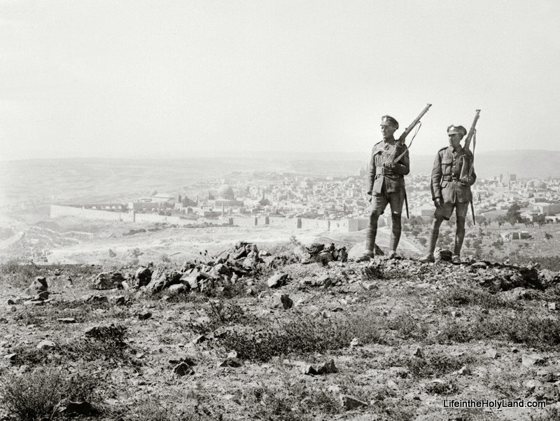
The photograph was taken shortly after the surrender of Jerusalem in 1917.  Two British sergeants armed with rifles are standing on Mount Scopus with the Old City of Jerusalem in the background. 

Through the haze you can see the city walls and the Dome of the Rock.  For the next 30 years, scenes like this would be common in Palestine: the British keeping watch over the holy sites and the local population.

In his book A Peace to End All Peace, historian David Fromkin describes the military campaign of the British in the following way as General Allenby and his troops swept into the region from the south:

In the autumn of 1917 Allenby invaded Palestine.  The Turks and their German commanders expected him to launch his attack on coastal Gaza, the obvious gateway to Palestine; but its defenses and defenders were well prepared and Allenby merely feinted at it while, with stealth and speed, his main forces swung around through the desert to attack inland at Beersheba instead.  The Ottoman forces were taken by surprise, and fell back in disarray…. Allenby, having pushed the Turkish right flank north of Jaffa, then thrust through the Judaean hills, and captured Jerusalem … On 11 December 1917 General Sir Edmund Allenby and his officers entered the Holy City of Jerusalem at the Jaffa Gate, on foot.  At the Citadel, Allenby read out a proclamation placing the city under martial law.  To the French representative, Picot, Allenby explained that the city fell within the military zone, so that authroity in the area was vested solely in the commanding general.  As commanding general, Allenby would decide how long the area would remain under an exclusively military administration.  Only when he deemed that the military situation permitted him to do so, said Allenby, would he allow civil administration to be instituted.  (David Fromkin, A Peace to End All Peace [New York: Henry Holt and Company, 1989] pp. 311-312.)

Thus began a 30-year period when the British controlled the Holy Land.

This picture and over 400 others are included in Volume 7 of the American Colony and Eric Matson Collection, and can be purchased here for $15 (with free shipping).  A photograph of Allenby’s entrance into Jerusalem is available here on LifeintheHolyLand.com, and a photo of German prisoners of war entering Jerusalem in 1917 is available here.
Share:

(Post by Seth M. Rodriquez)

Over the last few days, swarms of locusts have threatened Israel and Egypt.  The Egyptian swarm was estimated to be at least 30 million insects, while the swarm that entered Israel was only about 1 million.  In 1915, a similar locust swarm wreaked havoc in Palestine, and photographers and scientists had one of their first opportunities to study these insects up close.

In Volume 6 of The American Colony and Eric Matson Collection, there are over 80 pictures of the locust plague of 1915 as well as a copy of an article published in the National Geographic about the incident.  Locusts are mentioned over 30 times in the Bible, and the 1915 invasion provided researchers with new insights into these creatures and the damage they can cause when they travel in such large numbers.  Essentially what happened was the locusts flew into the region from the northeast, laid their eggs in various places, the parents died while the eggs hatched, the larvae crawled for miles in a direction back toward the northeast, and after reaching maturity the young insects flew off towards the east. Through this whole process, the insects ate everything in their path: the adults ate on their way in and the young ate on their way out … or as Joel 1:4 put it: “What the cutting locust left, the swarming locust has eaten. What the swarming locust left, the hopping locust has eaten, and what the hopping locust left, the destroying locust has eaten.” (ESV)

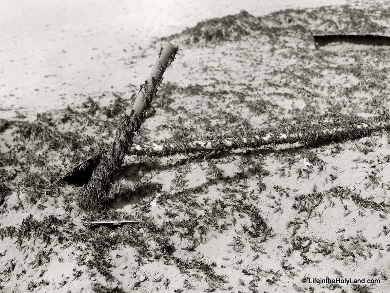
In the photo above (click to enlarge), the crawling locusts are covering digging tools used by the residents of the area to fight the onslaught of the insects.  The fought them in various ways:

  • Digging up the eggs before they hatched.
  • Setting up long lines of metal sheets and directing the locusts to pits in the ground where the locusts would be squashed (by men holding their noses) and then buried.
  • Poisoning them by adding arsenic to grain and spreading the grain in their path.
  • Using a flame thrower to burn the insects while they ate the vegetation.

The entire episode, both the insect itself and the responses of the locals, is extremely fascinating.

Some Muslim locals were resigned to the fact that the locusts had been sent by Allah and thus there was no use in fighting them. Other locals tried to trick the authorities when they were required to gather a certain quota of locust eggs (for example, by rolling white clay into what looked like a locust egg). Still others joined the fight against the insects. The following story of one fight against the locusts is recorded in the National Geographic article:

One evening while trapping them on the upper side of the hill we learned just in time that an immense number were just about to enter the property from the opposite side. At once all efforts turned in this direction, and the trap was sunk into the lower edge of the field toward which they were making; but no sooner had it been set in place than the locusts again changed their course. Notwithstanding the laborious task involved, the trap had to be moved, during which process it was nip and tuck to keep the locusts from escaping. Once, however, they made in the right direction, they jumped, hundreds at a time, into this death trap.

The evening hours were now upon us; the locusts, weary from being driven and benumbed from the cool breezes, seemed to near the trap exhausted, while those behind kept piling up till the earth for a small space was covered layers deep. To facilitate matters, with spade and rake they were scraped into the trap, now constantly being emptied.

Thus in about an hour’s time four large sacks full were caught and destroyed each containing no less than 100,000 of these insects. Many escaped and made for a near-by thorny patch, on which was now piled more dry sticks and thistles, which when set afire burned alive many thousands more. The above is but average example showing how and in what quantities they were caught. (John D. Whiting, The National Geographic Magazine, Volume XXVIII, No. 6 [Dec. 1915], pp. 535-536.)

By way of contrast, this week the Israeli authorities were able to eliminate a swarm of locusts by spraying pesticides over thousands of acres in a single day.  One hundred years of developments in technology can go a long way.

This photograph and over 600 other images of “Traditional Life and Customs” are available in Volume 6 of The American Colony and Eric Matson Collection and can be purchased here for $20 (with free shipping).  See here for another photograph of the crawling locust in this collection, and see here for a previous post on this locust plague with two additional pictures.

Share:

(Post by Seth M. Rodriquez)

From the legend of Atlantis to the recent ABC television series called Lost, disappearing islands have always fascinated people.  Modern history tells the story of another disappearing island, but unlike other stories, there is little mystery about why it happened.

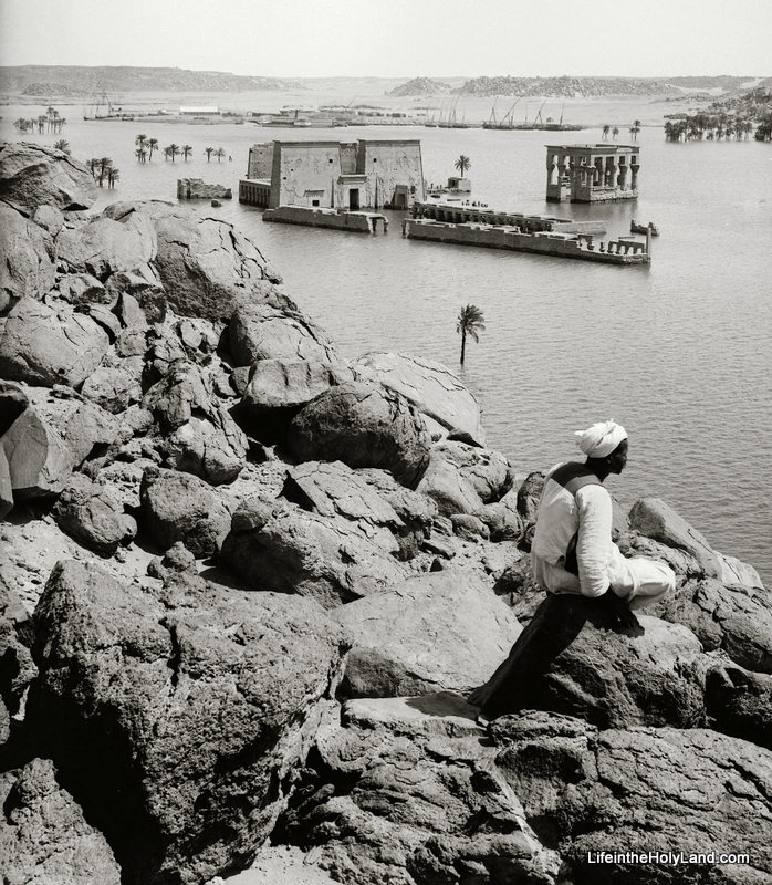
Our picture of the week (the second image displayed below) comes from Volume 5 of The American Colony and Maston Collection which focuses on Egypt and Sinai.  To show the development of the site over the last century, I have also included a drawing from Picturesque Palestine, Sinai and Egypt and a photograph from the revised Pictorial Library of Bible Lands in this week’s post.

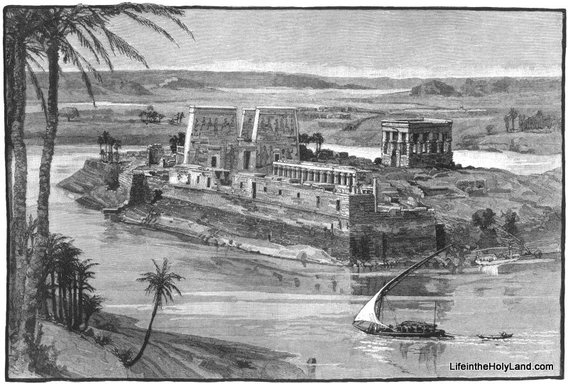
From the Roman Period until the late 19th century, the island sanctuary of Philae looked similar to the image below.  A temple to Isis was built on the site in the Roman Period and later was converted to a Christian worship site.

Philae in the 1800s

In 1898, the British constructed the Aswan Dam near the first cataract of the Nile.  The dam helped control the flow of the Nile River but it also flooded the area to the south, including the island of Philae.  The ruins of Philae were partially submerged, as can be seen in the photo below.  This photo was taken sometime between 1910 and 1920.  (Volume 5 of The American Colony and Eric Matson Collection includes a couple of pictures of the Aswan Dam when it was in use, and of tourists visiting Philae by boat.) 

Philae in the Early 1900s

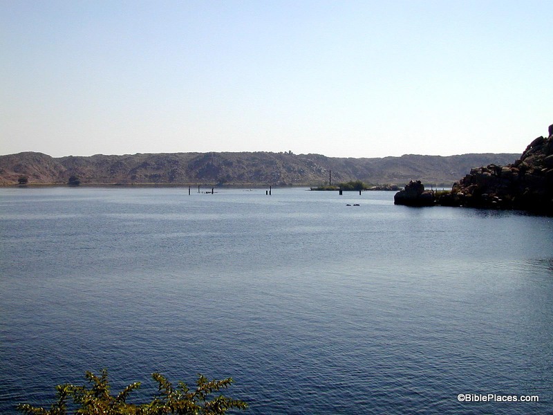
In the 1960s and early 1970s, the High Dam was built which raised the waterline even further.  So if you visit the area today, there is nothing left of the island of Philae.  Fortunately, the ruins on the island were dismantled and moved to the nearby island of Agilika, so you can still see the ruins of Philae … you just can’t see them in their original spot.

Philae Today

The photograph of the partially submerged ruins of Philae and over 450 others images of Egypt and Sinai are available in Volume 5 of The American Colony and Eric Matson Collection and can be purchased here for $15 (with free shipping).

The drawing of the island before the dams were built is from Volume 4 of Picturesque Palestine, Sinai and Egypt which can be purchased for $20 here (with free shipping).

The photo of Philae today is from Volume 7 of the Pictorial Library of Bible Lands, Revised and Expanded Edition which can be purchased here for $34 (with free shipping).

Additional images and information on Philae can be found here on LifeintheHolyLand.com and here on BiblePlaces.com.

Share:

(Post by Seth M. Rodriquez)

What is it about old photographs that make them so fascinating? 

I think part of the answer lies in our natural curiosity about the past.  What did things look like back then?  And to a student of archaeology, old photographs of archaeological sites can be especially fascinating because it raises the question: What did things look like when the first archaeologists stepped onto the scene?

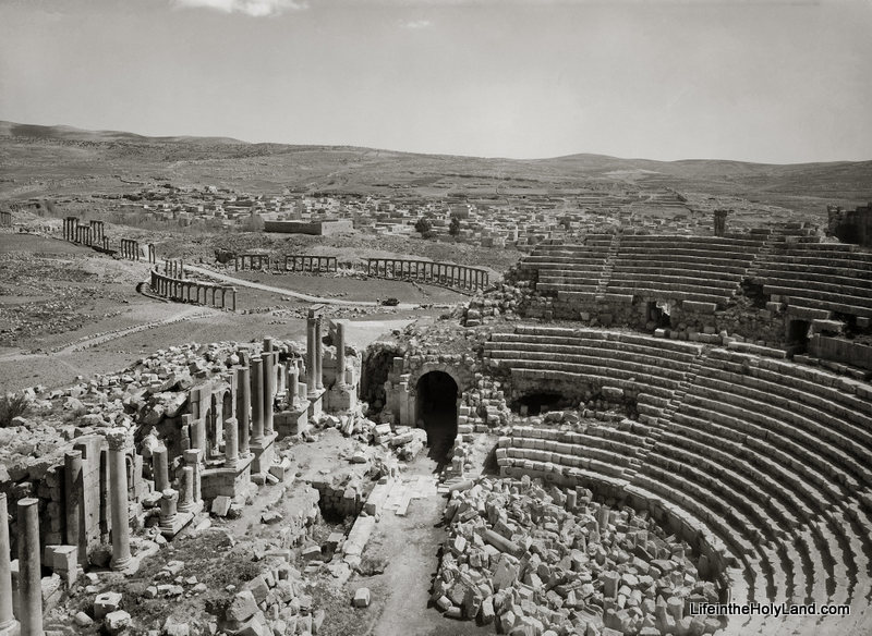
Our picture of the week comes from Volume 4 of The American Colony and Eric Matson Collection, which focuses on Lebanon, Syria, and Jordan. In the photo below, you can see the southern theater and the forum at Gerasa (a.k.a., Jerash) in the modern country of Jordan.  Gerasa was one of the cities of the Decapolis, and “the country of the Gerasenes” is mentioned in Mark 5:1, Luke 8:26, and Luke 8:37.

The photo was taken sometime between 1920 and 1933. Another early photograph of the forum can be found here on LifeintheHolyLand.com. By way of contrast, this page on BiblePlaces.com shows you what Gerasa looks like today, after the archaeologists have excavated, cleaned up, and reconstructed these ruins. The differences between then and now are striking.

The American Colony and Eric Matson Collection is a wealth of information and has a variety of uses:

  • For the archaeologist, this collection provides photographs of early digs and of sites as they looked before excavations. For better or worse, this was an age when a lone scholar stood over a team of local workers who moved tons of dirt in a single season (and this practice can be seen in the collection). Yet this was also a period when things were fresh and exciting as archaeologists were digging into sites for the first time.
  • For the preacher and teacher, this collection provides additional material which can be used to transport your listeners back to a culture and landscape similar to biblical times. It also can be used to discuss geography or illustrate particular sites.
  • For the historian, this collection provides windows into this dramatic period of history. This was the period of the late Ottoman Empire and the British Mandate when Jewish immigrants were migrating to Palestine and establishing new settlements. It was also a time when technology was on the rise: electric stations and telephone stations were being built, railroads were being constructed, and automobiles and airplanes were coming onto the scene.
  • For the artist and graphic designer, this collection provides many beautiful, crisp, black & white photos of places in the Holy Land that can be used in a variety of ways.  These photos still capture people’s attention and fire their imaginations.

This photograph and over 700 others are available in Volume 4 of The American Colony and Eric Matson Collection and can be purchased here for $20 (with free shipping).  Historic images of other Roman cities can be seen here, here, and here on LifeintheHolyLand.com.

Share:

(Post by Seth M. Rodriquez)

Joshua 3:15 makes the following comment in passing: “now the Jordan overflows all its banks throughout the time of harvest” (ESV). In the context of this chapter, Israel is about to cross into the Promised Land over a miraculously dry riverbed and this comment is included to give greater significance to the miracle. But before you rush to the Jordan with your camera during the next harvest season to snap a photo of this natural phenomena, let me save you some shekels by telling you that the flooding of the Jordan River is not something that happens today.

According to a 2010 report about the Jordan River (noted previously on this blog here), the Jordan River contains only 3% of the water that it did 100 years ago.  According to that report, the river discharged 1.3 billion cubic meters of water in the 19th and early 20th centuries (but see a more conservative estimate in the quotation below from the Encyclopaedia Judaica).  The report contrasts this with the current discharge of the river which is 20 to 30 million cubic meters.  Or to put it in numerical form:

  • 1,300,000,000 cubic meters per year in the past.
  •     30,000,000 cubic meters per year today.

 So “overflowing all its banks” is not a phrase that is typically used when describing the Jordan River today.

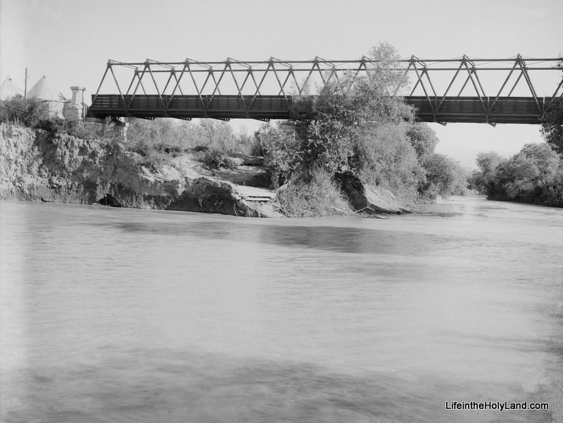
Fortunately, we have photographs from the first half of the 20th century that can help us illustrate this biblical phrase.  Our picture of the week (and a bonus picture) come from Volume 3 of The American Colony and Eric Matson Collection which focuses on Southern Palestine.  To show the contrast in the river’s levels, I have included two photos from that collection.  The first photo is a picture of the newly constructed Allenby Bridge with the Jordan River flowing peacefully about 30 feet below it. 

(As a side note, this is not the Allenby Bridge/King Hussein Bridge used today, but merely a forerunner of the modern bridge.)

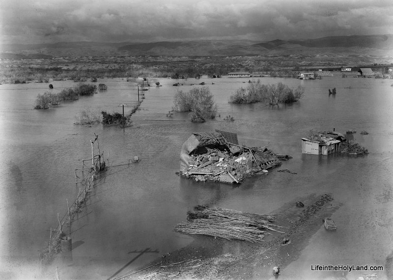
The date of the photograph above is around 1920.  The photograph below was taken in February, 1935.  This was an unusually high year for the Jordan River and it “overflowed all its banks,” damaging and destroying surrounding buildings and roads.

If you look closely in the upper right section of the photo you can see the Allenby Bridge with its bottom edge touching the water.  A closer view of the bridge can be seen in another photo from the collection which is posted here.

This flood year is mentioned in passing in the Encyclopaedia Judaica:

The Jordan discharges c. 875 million cu. m. into the Dead Sea a year; its yearly fluctuations are great and are caused mainly by the Yarmuk: in 1933, 287 million cu. m. and in 1935, 1,313 million cu. m.

According to this statistic, the Jordan River discharged 50% more water that year than the yearly average.  There is no way of knowing how much water was discharged during the year that Joshua and the Israelites crossed, but we can be certain that the photograph above is a much better illustration of how it looked than any picture that could be taken today.

Fortunately the future of the Jordan River is looking brighter.  This last summer, this blog noted a report about a plan by Israel to divert some additional water to Jordan River (see post here).  Perhaps future generations will again be able to see the Jordan overflow its banks.

These photographs and over 550 others are available in Volume 3 of The American Colony and Eric Matson Collection and can be purchased here for $20 (with free shipping).  Other historic images of the Jordan River can be seen here and here on LifeintheHolyLand.com, as well as a page devoted to illustrating Joshua and the Israelites “Entering the Promised Land” here

Share:

(Post by Seth M. Rodriquez)

This was a difficult week to come up with a photo to share.  The problem wasn’t due to a lack of good material … the problem was that there were too many good photos available!

This week’s photo comes from Volume 2 of The American Colony and Eric Matson Collection, which focuses on Jerusalem.  These are photographs of Jerusalem taken in the first half of the 20th century before many of the modern developments were built.  So much has changed in the city since that time (both physically and politically) that this volume is a gold mine of material for Jerusalem studies.

Here is a list of some of the photos I could have chosen for this week’s post:

  • The City of David when it was still being used for farmland.
  • A German zeppelin hovering over the Old City.
  • The interior of the Golden Gate on the Temple Mount.
  • The interior of the Double Gate on the Temple Mount.
  • The interior of Solomon’s Stables in the Temple Mount (but see here for a similar photo).
  • The interior of the Hurvah Synagogue before it was destroyed in the War of Independence.
  • The Pool of Hezekiah filled with water instead of trash (but see here for similar images).
  • Sealed entrances to the Church of the Holy Sepulcher.
  • The short-lived and aesthetically questionable clock tower built on top of Jaffa Gate (but see here for a previous post on that subject).
  • Remains of a Crusader-period monastery in the Kidron Valley, a small portion of which was only briefly excavated in 1937 and then buried again.
  • Crowfoot and Fitzgerald’s 1927-28 excavations in the City of David.
  • A smog-free landscape looking east which includes the Hinnom Valley, Mt. Zion, the Judean Wilderness, the Dead Sea, and the mountains of Moab.
  • The Jewish Quarter and the Western Wall as they looked before the War of Independence (but see here for a similar photo).

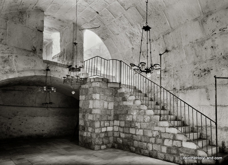
Instead, I will present the following rare photo of the interior of Barclay’s Gate (or at least the top section of the gate) on the western side of the Temple Mount, taken sometime between 1940 and 1946.


Barclay’s Gate was one of the entrances to the Temple Mount during the Second Temple Period (the time of Jesus and the apostles). A modern photo of the outside of Barclay’s Gate, in the women’s area of the Western Wall Plaza, can be seen here.  Only the stone that formed the lintel is visible today from the outside.  In the PowerPoint notes included in the collection, Tom Powers explains what we can see in the photograph above:

This fascinating photograph (looking northwest) shows a room lying beneath the surface of the Temple Mount (to Muslims, the Haram esh-Sharif, or “Noble Sanctuary”). This space was the subject of several descriptions and drawings by 19th century explorers but has rarely been seen by Westerners—or photographed. Much better known, actually, is the opposite side of the thick wall seen here at the end of the vaulted room: it is the massive lintel and blocked opening of an original western entrance of the Herodian Temple Mount, the so-called “Barclay’s Gate” partially visible in the very southern end of today’s Western Wall (women’s prayer area).  

The ancient gate was identified in modern times by James T. Barclay, an American Protestant medical missionary and amateur explorer of Jerusalem’s ancient places. In the course of recounting his identification of the exterior gate elements, Barclay also described the space pictured here: 

“During the period of my admission into the Haram enclosure I discovered in this immediate vicinity, on the interior, a portion of a closed gateway, about fourteen or fifteen feet wide; but whether it is connected with that on the exterior, I was not enabled to determine, for the guards became so much exasperated by my infidel desecration of the sacred room, el-Borak, where the great prophet tied his mule on that memorable night of the Hegira, that it was deemed the part of prudence to tarry there but a short time and never to visit it again . . . . Only the upper portion of the gateway can be seen—the lower part being excluded from view by a room, the roof or top of which is formed by the floor of this small apartment.”
— James Barclay, City of the Great King (1857), pp. 490-91 

In the passage quoted above Barclay, alas, garbles some elements of the Muslim tradition (he calls the mythical beast a “mule” and confuses Mohammed’s Night Journey with the hegira, his flight from Mecca to Medina). Nonetheless, his notion that this “small apartment” might be connected to the gate he had identified from the outside was correct, as confirmed by other explorers only several years later. Barclay was also correct that the mosque occupied only the uppermost part of the gateway. But, whereas Barclay presumed the existence of a lower room, the mosque actually overlies a great volume of debris deposits (or fill) behind the blocked gate. 

In this photo, the vaulting overhead is the top of the Herodian gate passage, and the dark line in the masonry of the far wall (beneath the shallow arch) corresponds to the bottom of the great lintel (apparently the lintel itself is not visible). Experts estimate the height of the Herodian gate opening, from sill to lintel, at 25 to 30 feet (7.8 to 9.3m), with the sill lying only a few yards (meters) above the Herodian street. Thus, in the original gate passage here, a broad stairway no doubt ascended (far beneath the floor shown here) toward the east and the surface of the Temple Mount. The original passage ran eastward from the western wall for at least 70 feet (22 m), but it was reconfigured and altered in many ways over the ages. For example, the distinctive arch of chamfered voussoirs (beveled and molded arch-stones) seen here, and others like it, point to a major redesign and rebuilding of the passage in Omayyad times (7th-8th centuries), when the gate was still open and in use. Since the Arab chronicler Al-Muqadassi in 985 still lists the gate (called by him, and all previous Arab sources, Bab Hitta) among the active entrances into the Haram, it must have gone out of use and was blocked sometime after that date. The eastern part of the passage was walled off at some point, plastered, and used as a cistern. 

The “al-Buraq” Mosque pictured here, again, is built into the vaulted internal gate passage of Barclay’s Gate, along the western wall and inside the Haram (Temple Mount) enclosure. It is situated immediately next to the Mughrabi Gate, to the north, and below the level of the Haram platform, from which it is accessed by the two flights of stairs pictured here. The Matson-supplied date for this photo is 1940 to 1946, and the mosque apparently still exists today. … 

This photograph and over 650 others are available in Volume 2 of The American Colony and Eric Matson Collection and can be purchased here for $25 (with free shipping).  Other historic photos can be seen on various pages of LifeintheHolyLand.com.  You can find the links the Jerusalem pages in the left column of the homepage.

Share: