(Post by Seth M. Rodriquez)

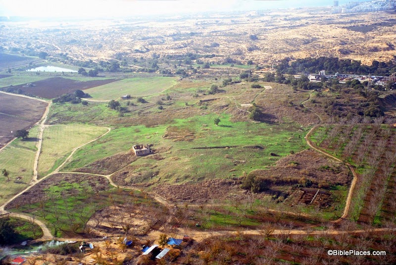
Our picture of the week is an “elephant in the room,” archaeologically speaking. This site was occupied by Israel’s most notorious neighbor, was a flourishing city 100 acres in size, and was once a resting place of the Ark of the Covenant. Yet this site is hardly (if ever) visited by tourists in Israel today. Thus, we continue our series of “obscure sites” with a map and photograph of the Philistine city of Ashdod.


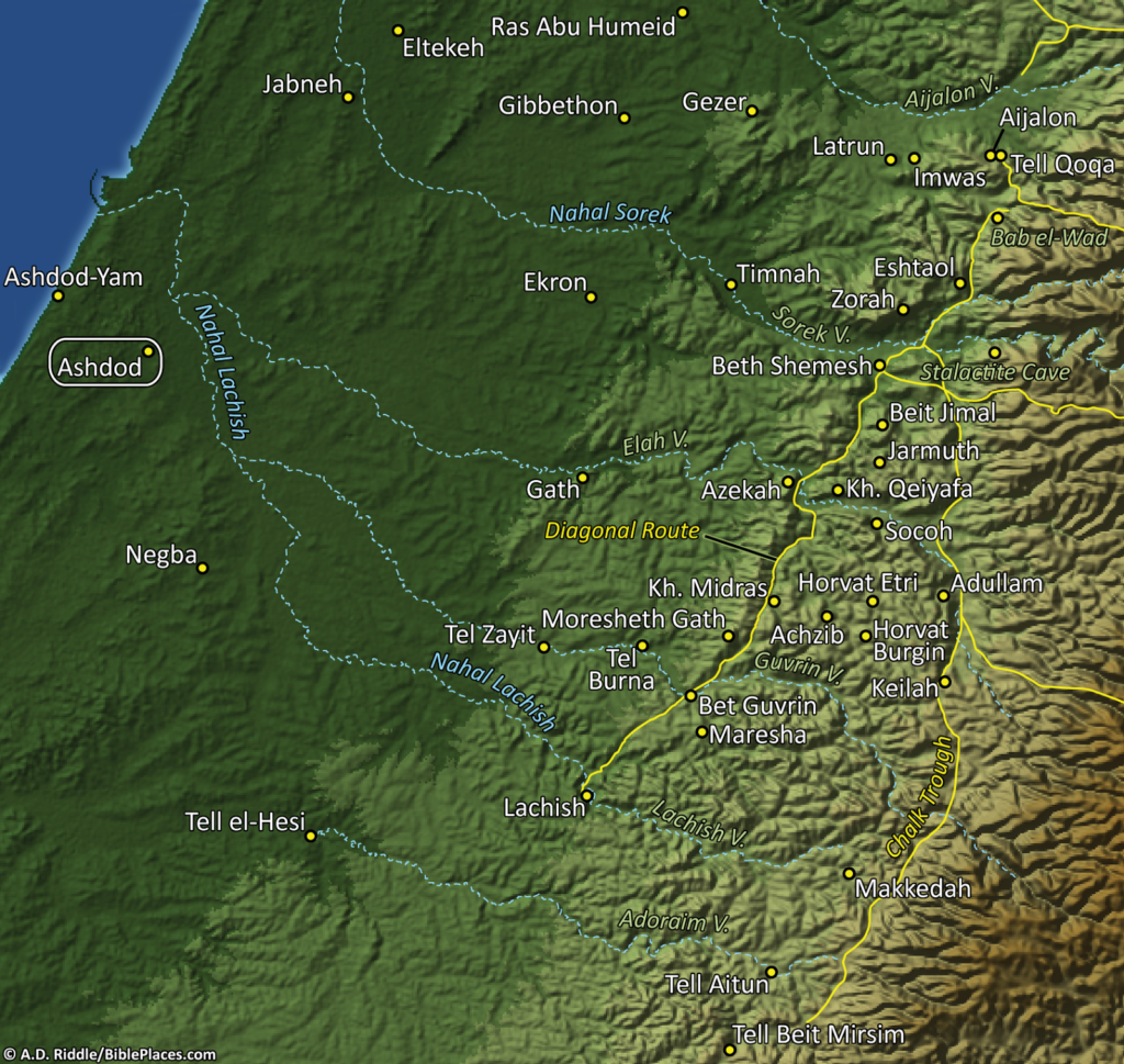
Ashdod is located only 3 miles (4 km) from the Mediterranean coast. In ancient times it possessed some prime real estate along the main international highway that passed through the Levant, which helped contribute to the city’s wealth and prominence. In the map below (included in the PowerPoint files in Volume 4 of the PLBL), Ashdod can be seen in the far left. (Click on the image to enlarge it.)


The site was excavated for nine seasons in the 1960s and 70s. Remains from the Middle Bronze period to the Byzantine period were found here. At its largest size, the site was comprised of an upper city of at least 20 acres and a lower city of at least 70 acres.

The city reached this peak size during the time of the Philistines, when it was one of the five major cities of Philistine coastal plain (along with Ekron, Gath, Ashkelon, and Gaza). Amihai Mazar summarizes the archaeological findings at Ashdod from this period in the following way:

At Ashdod the first Philistines settlement (Stratum XIII), although unfortified, was a well-planned and densely built city, some twenty acres in area. … The next two levels at Ashdod (Strata XII-XI) denote successive rebuildings of the Philistine city in the twelfth and eleventh centuries B.C.E. In Stratum XII the ruined fortifications of the last LB II city (Stratum XIV) served as foundations of a solid city wall. At the end of the eleventh century B.C.E. (Stratum X), Ashdod expanded to a size of about 100 acres, thus becoming one of the largest cities in the country. In this time Ashdod was surrounded by a solid wall with a four-chamber gate. This enlarged city endured for a long time in Iron II.

During this period is when the Ark of the Covenant was captured by the Philistines in a battle against the Israelites (1 Sam. 4:1-11). The Ark was carried back to Ashdod and set in the temple of the Philistine god Dagon. As the story unfolds in 1 Samuel 5, this turn of events did not bode well for the statue of Dagon. It was supernaturally knocked down twice and consequently had its head and hands broken off. Furthermore, the people of the city were struck with a plague of tumors. So eventually the people of Ashdod sent the Ark to the neighboring city of Gath, where it wreaked further havoc on the Philistines.

The city of Ashdod also appears in several other places in the Old Testament. It is noted in the book of Joshua that it was not conquered by the Israelites when they entered the land of Canaan (Josh. 13:1-3), but several hundred years later it was conquered by King Uzziah of Judah (2 Chr. 26:6-7) and then by the Assyrians (Isa. 20:1-2). The city also is mentioned (and targeted!) in a number of prophesies in the Old Testament (Amos 1:8; 3:9; Isa. 20:1-2; Jer. 25:20; Zeph. 2:4; Zech. 9:6). Finally, in the book of Nehemiah the people of Ashdod opposed the rebuilding of the wall in Jerusalem (Neh. 4:6-8) and intermarried with some of the Judeans (Neh. 13:23-27).

Although this site has an immense significance both biblically and archaeologically, it is not currently set up to host tourists. When I visited the site in 2006, I was on my own in a borrowed car. I had to park and walk through an orchard to get to the site. Nothing was marked and I couldn’t even get to the top of the acropolis. The tell is bordered by industrial buildings and there is nothing there to indicate that this was once the thriving Philistine metropolis of Ashdod. And so, this once important city sadly finds itself among the “obscure sites” of the Holy Land.

This photo and over 1,500 others can be found in Volume 4 of the Pictorial Library of the Holy Land and can be purchased here for only $39 (with free shipping). Additional pictures and information about other Philistine cities can be found on the BiblePlaces website here and here, and on the LifeintheHolyLand website here.

The excerpt above is taken from Amihai Mazar, Archaeology of the Land of the Bible: 10,000-586 B.C.E., The Anchor Bible Reference Library (New York: Doubleday, 1990), p. 308, which is available for purchase here.

Post Script:  For those of you who may be interested, I have posted a review of the Rose Then & Now Bible Map Atlas on my personal blog here. Specifically, the review focuses on the electronic version published by Logos Bible Software.

Share:

Aviva and Shmuel Bar-Am tell the fascinating story of Moses Shapira and his alleged discovery of an ancient scroll of Deuteronomy. The Times of Israel article includes quite a bit of interesting information about Christ Church, even though it is not really relevant to the story. The question that has never been resolved is whether Shapira held the first discovered Dead Sea Scroll.

Christ Church was the first Protestant church in the entire Middle East, and the only evangelical church in the region. Outwardly resembling a grand European synagogue more than a Christian house of worship, it was erected in 1849 by the London Society for the Promotion of Jews to Christianity for the express purpose of drawing Jews into the Christian fold.
Before that time, simple proselytizing — and the promise of financial gain — had resulted in very few Jewish conversions; the Protestant Bishopric in Jerusalem hoped that an attractive, accessible church might facilitate the cause.
Church fathers wanted Jews to feel comfortable in the sanctuary, which is why the interior is replete with Jewish symbols.
Jewish students at the workshop manufactured the stunning olive wood communion table, decorated with both a Star of David and the Christian Alpha and Omega.
There were no crosses in the church; the cross on the table appeared in 1948, when Jordanians captured the Old City and Anglicans feared their sanctuary would be mistaken for a synagogue.
Moses Wilhelm Shapira, born Jewish in 1830, was 25 when he left his Russian homeland for the land of Israel.
Somewhere along the way, he converted to Christianity.

The full story is here. Shapira’s story is told in greater length in Neil Asher Silberman’s Digging for God and Country: Exploration, Archaeology, and the Secret Struggle for the Holy Land.

UPDATE: See the Jim Davila’s comments here.

Christ Church, tb011612801
Christ Church in Jerusalem
Photo from Pictorial Library of Bible Lands
Share:

Baker has recently published a book worthy of mention here: The World of the New Testament: Cultural, Social, and Historical Contexts, edited by Joel B. Green and Lee Martin McDonald.

You can use the “Look Inside” feature at Amazon to read the Table of Contents. Here are some of the chapters I would read first:

Chapter 5: The Herodian Dynasty, by Everett Ferguson

Chapter 13: Slaves and Slavery in the Roman World, by S. Scott Bartchy

Chapter 15: Education in the Greco-Roman World, by Ben Witherington III

Chapter 16: Temple and Priesthood, by David Instone-Brewer

Chapter 26: Jewish Education, by Kent L. Yinger

Chapter 28: Reading, Writing, and Manuscripts, by E. Randolph Richards

Part 5: The Geographical Context of the New Testament includes chapters on Egypt, “Palestine” (eek!), Galatia, Macedonia, Achaia, and much more.

Though this work draws from a broad range of authors, some more conservative than others, overall this seems like a terrific resource. At $35 for a 640-page hardcover, this is a good value.

Share:

The collapse of the great civilizations of the Late Bronze Age was the result of climate change, says a new study published in Tel Aviv. A preliminary list of 2014 excavations in Israel is now available. The Carmel Caves have been named the newest UNESCO World Heritage Site. The Bible Lands Museum Jerusalem has opened “The Book of Books” exhibition based on the collection of Hobby Lobby owner Steve Green. Archaeologists are mapping the ancient aqueducts of Rome with the help of lasers and robots. A new BAR Archive DVD is available, providing all issues of the magazine from 1975 to 2012. Wayne Stiles is offering both of his excellent books at a great discount. And this weekend will be the last chance to get them autographed. They make a great Christmas gift for you or someone else… The Virtual Bible Project is profiled in the Baptist Press. After many years of slow progress, Dan Warner has now teamed with Logos Bible Software to add to the four reconstructions already completed. J. B. Hennessy died this week. HT: Bill Soper, Jack Sasson, Charles Savelle, Joseph Lauer Mount Carmel cave with prehistoric remains, tb050900101 Caves on Mount Carmel
Photo from Samaria and the Center

Share:

From World Bulletin:

What could be the largest discovered inscribed tablet (stele), dating to the reign of Babylonian king Nebuchadnezzar II between 605-562 BC, has been discovered in the Turkish city of Karkamis on the military zone along the Turkey-Syria border. […] Excavations this year also unearthed a cuneiform tablet at the palace of Carchemish king Katuwa dating to 800 BC, as well as over 300 sculptures, a Luwian hieroglyphic inscription and a mosaic.

The rest of the article includes more information on the excavations but unfortunately nothing about the major discovery. For previous posts on the excavations at Carchemish, see here, here, and here.

Share:

(Post by Seth M. Rodriquez)

Our series on “Obscure Sites in the PLBL” hit a little snag this week as I turned to Volume 3 which focuses on Jerusalem. How do you pick an “obscure site” in a place as famous and as familiar as Jerusalem?  The solution is to go underground …

Our obscure site for this week is The Burnt House in the Jewish Quarter of the Old City of Jerusalem. This place is probably familiar to many readers of this blog, but I don’t think it makes it onto the itinerary of many tours to the Holy Land so it qualifies as “obscure.” This is a site that dates back to the destruction of Jerusalem by the Romans in the first century. In his book, The Holy Land, Jerome Murphy-O’Connor introduces the site in this way:

A month after the destruction of the Temple and the Lower City in early September AD 70, the Romans stormed into the Upper City: ‘when they went in numbers into the lanes of the city, with their swords drawn, they slew without mercy those whom they overtook, and set fire to the houses whither the Jews had fled, and burnt every soul in them’ ([Josephus,]  War 6: 403). This was one of those houses. The latest coin found among the charred debris on the floor was dated AD 69; an unused spear stood in one corner.

One thousand, nine hundred years later, archaeologists working under Nahman Avigad uncovered this house that (presumably) had been destroyed by the Romans. What you see in the picture above is the bottom level of the house. Leen Ritmeyer has posted his reconstruction of the entire house on his blog here, along with some newspaper clippings from the time of its discovery. While discussing this site, Avigad once wrote:

This house was destroyed by an intense fire and was filled with fallen stones, wooden beams (carbonized) and layers of ash. The plastered walls were completely covered with soot, and the debris concealed many artefacts. What is unique here is the fact that the debris had not been cleared away or disturbed by later construction: Everything remained just as it was when the building was destroyed.

Many of these artifacts can be seen in the museum which now sits under the buildings of the modern Jewish Quarter. The most chilling aspect of this discovery was the fact that the archaeologists found the skeletal remains of an arm of a young woman, lying on the threshold of the entrance. Presumably this was one of the victims who died at the hands of the Romans in AD 70.

This photo and over 1,500 others (including pictures of the artifacts on display in The Burnt House Museum) are available in Volume 3 of the Pictorial Library of Bible Lands, and can be purchased here for $39 (with free shipping). If you care to visit the site on your next trip, the Burnt House Museum is located at 2 Hakaraim Street, Jerusalem, near the top of the long staircase that leads down to the Western Wall Plaza.

The first excerpt was taken from Jerome Murphy-O’Connor, The Holy Land: An Oxford Archaeological Guide from Earliest Times to 1700, 4th ed. (Oxford: Oxford University Press, 1998), pp. 73-74.  The 5th edition can be purchased here.


The second excerpt was taken from Nahman Avigad, “Excavations in the Jewish Quarter of the Old City, 1969-1971,” p. 46, in Jerusalem Revealed: Archaeology in the Holy City 1968-1974 (Jerusalem: The Israel Exploration Society, 1975).

Share: