Archaeologists in Jerusalem have made a significant discovery of one of the quarries used in the construction of Herod’s Temple Mount.  Located 3 miles (4 km) northwest of the Old City, the 1.25-acre quarry has remains of massive stones measuring 9-25 feet (3-8 m) long, comparable to the stones visible in the Western Wall today.  The quarry is located near the main road coming from the north and at an elevation that is 250 feet (80 m) higher than the Temple Mount, making it an ideal location for quarrying activity.  Coins and pottery found in the quarry help to secure the date of its use to the 1st century B.C.  The story is carried by the Jerusalem Post, Haaretz, and Arutz-7.

Photo below: Another quarry that many believe was used by Herod’s crews is the so-called “Solomon’s Quarries,” near the Damascus Gate of the Old City.

Solomon's Quarries, tb051706274
“Solomon’s Quarries”
Share:

A legal attempt to stop the Temple Mount destruction was met with more governmental corruption today.  A five-minute video by Arutz-7 describes how the court chose to meet behind closed doors without allowing the participation of the plaintiffs.  If there’s a case for allowing Muslim destruction of Jewish antiquities, it should be made publicly and not hidden behind the skirts of political cowards.

UPDATE (9/21): The Jerusalem Post has a written version of the story here.  Key quotation:

“It is more than clear that Prime Minister Ehud Olmert has instructed the Antiquities Authority to cooperate with the Wakf and conceal the damage to antiquities being done during the infrastructure work at the site,” said Hebrew University archeologist and leading Temple Mount expert Dr. Eilat Mazar.

Share:

Excavations were resumed in June on Mount Zion after a long hiatus (since 2000).  The “Mount Zion Archaeological Expedition is directed by Shimon Gibson and James Tabor and looks very promising. 

After only five days of fieldwork this summer, they report the discovery of:

  • Well-preserved houses from the 1st century A.D.
  • Clear abandonment of the area during the Late Roman period (c.70-330 A.D.)
  • Preservation of the area during construction of the Nea Church (c. 530 A.D.)

You can read a 5-page report about the site and excavation (pdf, via Dr. Jim West).  Two seasons are planned for 2008 and it sounds like they will accept students as volunteers.  There are not many excavations in Jerusalem that are open to volunteers, so you might want to see what you can do to get in on this one.  I can personally testify that working in an excavation with Shimon Gibson is interesting and rewarding.

Mt Zion and Hinnom Valley aerial from se, tb010703
Mount Zion from southeast
Share:

A couple of Jerusalem archaeologists have audio interviews/conference calls online.  A 34-minute conference call with Gabriel Barkay is at www.onejerusalem.org.  Eilat Mazar is interviewed by Arutz-7 (direct link here; doesn’t seem to work in Firefox; 15 min. long).

On another subject, Ehud Netzer talks about his discovery of Herod’s tomb here (audio version here).

Share:

Haaretz reports:

A 70-meter-long segment of Jerusalem’s central drain dating from the Second Temple period was discovered Sunday by the Israel Antiquities Authority.
The segment is located between the Temple Mount and the Pool of Siloam. It apparently was part of a long drain that spanned from the Western Wall to the Kidron River, near the Dead Sea.
The drain stretched underneath the Old City’s main street, and cleared rainwater from the areas now known as the Jewish Quarter and the western section of City of David, as well as the Temple Mount, before the city’s destruction at the hands of the Romans in 70 C.E.
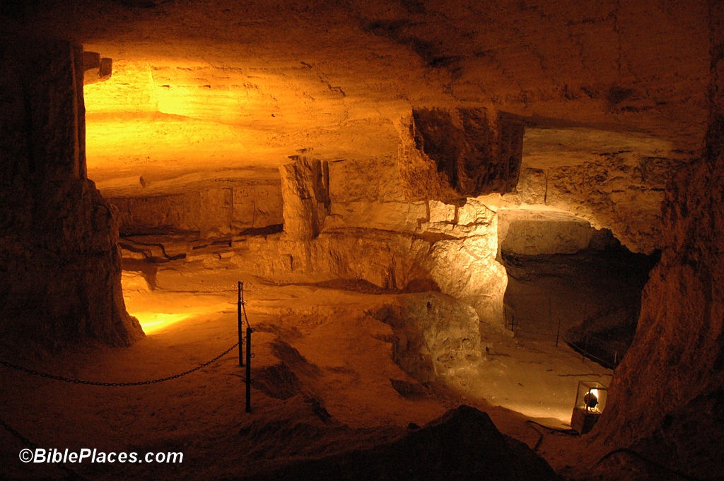
The excavation, conducted by the Antiquities Authority in conjunction with City of David Foundation, also found shards and coins from the period. The drain is made of massive slabs of stone, and is about three meters high and one meter wide.
The archeologists professors Roni Reich of the University of Haifa and Eli Shukrun from the Antiquities Authority, who are in charge of the excavation, say that the land that accumulated during 2000 years of landslides required them to dig 10 meters deep in order to reach ancient Jerusalem’s main street.
“According to Josephus, the historian who recorded the siege, occupation and destruction of Jerusalem, people found refuge in the drain until they managed to escape through the city’s southern gate,” they said.
The northern segment of the drain,  which is yet to be dug up, is believed to reach the Western Wall area, where another major drain was previously found. The archeologists assume that they are both part of the same drain.

Drains have been found in Jerusalem before, including other segments of this same drain.  But if the word “drain” doesn’t excite you, it may be because you missed the size of what they found.  The drain they uncovered was 70 meters (220 ft) long, 3 meters (10 ft) high and 1 meter (3 ft) wide.

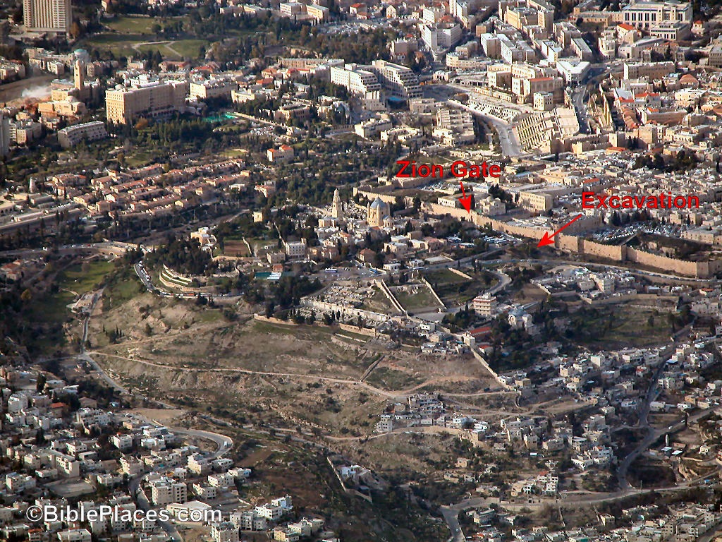
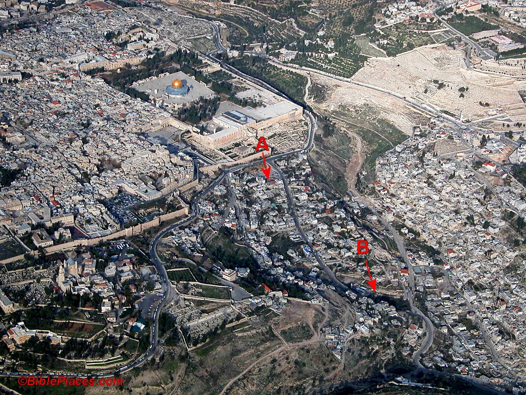
The article doesn’t state exactly where the drain is located, but Reich and Shukrun have excavated in two areas in recent years that are possibilities.  I think location B, depicted on the aerial photo, is more likely.  Earlier excavations and photos of this area were included in the February issue of the BiblePlaces Newsletter (not online, but see Leen Ritmeyer’s blog for a photo from it).

Temple Mount and City of David aerial from sw, tb q010703 
UPDATE: The AP article includes a photograph of the channel (HT: Joseph Lauer).  Very impressive.  The masonry on that drain is better than the masonry of most people’s houses in Jerusalem today.
UPDATE (9/10): Some of the artifacts found in the excavation are displayed in this photograph.
UPDATE (9/11): The Israel Antiquities Authority has issued a press release.
Share: