(Posted by Michael J. Caba)

This ongoing series of posts considers the historical reliability of the New Testament books of Luke and Acts by examining the relationship between these texts and other ancient sources while also giving background information on key elements of the various narratives.

One of the persons mentioned in Luke 3:1-2 is “Herod tetrarch of Galilee.” This particular Herod, who is also known as Herod Antipas, was the son of Herod the Great and Malthace, being born in 20 BC. After the death of his father, Herod Antipas was appointed by the Romans as ruler of Galilee and Perea over which he reigned from 4 BC to AD 39.

Herod appears at several points in the Gospels, with one notable event being his execution of John the Baptist who denounced Herod’s marriage to Herodias, his brother Philip’s former wife (Mark 6:17-29).

Later, during the trial of Jesus, Pontius Pilate learned that Christ was from Galilee and he therefore sent Jesus for examination to Herod, who was in Jerusalem at that time. Though Herod plied Jesus with “many questions,” he received no answers from the Lord. Still, the cooperation between Herod and Pilate led to a friendship between them (Luke 23:6-12).

In addition to such references as those noted above from the Gospels, Herod is also referred to by the historian Josephus. Concerning the aforementioned execution of John the Baptist, Josephus notes: “Now some of the Jews thought that the destruction of Herod’s army came from God . . . as a punishment of what he did against John, that was called the Baptist; for Herod slew him” (Antiquities 18.5.2).

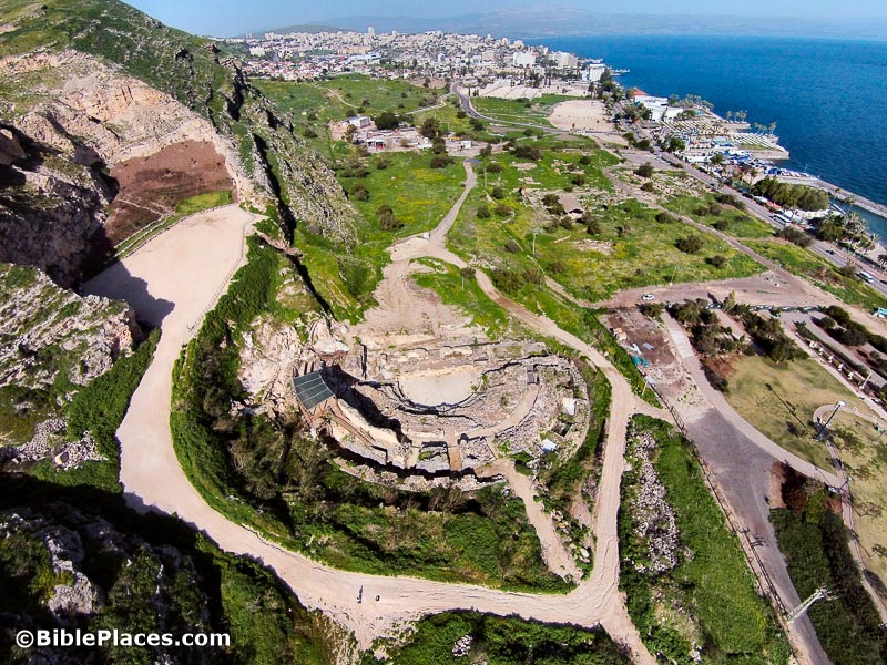
Josephus also notes the building projects undertaken by Herod in various passages including the following: “And now Herod the tetrarch, who was in great favor with Tiberias, built a city of the same name with him, and called it Tiberias” (Antiquities 18.2.3).

The photo shown below is an aerial view of the ruins of ancient Tiberias looking from the south.

For similar correlations between the biblical text and ancient sources, see Bible and Archaeology – Online Museum.

Share:

The tomb of Jonah is a traditional site and unless the prophet lived for more than a hundred years, this tradition has now been undermined by the discovery of a 7th-century palace built by the Assyrian king Sennacherib. The Times of Israel reports:

In July 2014, weeks after overrunning Mosul and much of Iraq’s Sunni Arab heartland, IS militants rigged the shrine and blew it up, sparking global outrage.
In mid-January, Iraqi troops in Nineveh liberated the site.
“(It is) far more damaged than we expected,” Culture Minister Salim Khalaf said.
But IS also dug tunnels beneath the shrine searching for artifacts to plunder.
Iraqi archaeologist Layla Salih told Britain’s Daily Telegraph that in the tunnels she discovered a “marble cuneiform inscription of King Esarhaddon thought to date back to the Assyrian empire in 672 BCE.”
[…]
Eleanor Robson, head of the British Institute for the Study of Iraq, said the terror group’s destruction had opened the way to a “fantastic find.”
“The objects don’t match descriptions of what we thought was down there,” she said, according to a Telegraph report. “There’s a huge amount of history down there, not just ornamental stones. It is an opportunity to finally map the treasure-house of the world’s first great empire, from the period of its greatest success.”
However, IS plundered many of the items that were in the palace. Khalaf estimated that more than 700 items have been looted from the site to be sale on the black market.

The full story has more sad news.

HT: Mike Harney

Share:

The Vatican and the Jewish community of Rome are collaborating on a new exhibition on the menorah.

Whenever Mosul is liberated from ISIS, a strategic plan will be in place for restoring its heritage.

Restoration work is underway on a colossal statue of Rameses II that once stood in the Karnak Temple.

Israeli border officials caught a Palestinian smuggler bringing in 53 ancient coins from Jordan.

Digital Giza is a virtual 3D model of the Giza Pyramids, and includes information about the history and archaeology of the site.

In an excerpt from his latest book, Eric Cline compares the archaeology of Masada with Josephus’s report and identifies discrepancies. Among his conclusions is that Josephus made up the story of the mass suicide to protect the Romans.

The updated Appian Media website has all 5 free episodes of “Following the Messiah” as well as a new subscription area with additional video clips and photographs.

Wayne Stiles visits the famous Cave of Machpelah in Hebron to see what it teaches about life, death, and God’s promises.

Ferrell Jenkins posts on several interesting ossuaries. See also a link in the comments to two of Tom
Powers’s articles on another ossuary probably related to the New Testament.

HT: A.D. Riddle, Charles Savelle, Joseph Lauer, Mike Harney, Ted Weis, Agade

Share:

Tabgha’s Church of the Multiplication of Fish and Loaves has re-opened after 20 months of restoration following the arson attack.

Hebrew inscriptions discovered on a Roman-period capital point to the Jewish history of the Druze village of Pekiin.

The oldest known sickle blades have been discovered on the shore of the Sea of Galilee.

Archaeologists working at Omrit have discovered a house decorated with frescoes dating to circa AD 100.

Robert Cargill suggests that “Cave 12” provides evidence that parchment was produced at Qumran.

Israel’s Culture Minister has offered to trade two elephants to Turkey in exchange for the Siloam
Inscription from Hezekiah’s Tunnel.

Israel’s Good Name describes a morning hike in the Ramot Forest on the north side of Jerusalem where a herd of gazelles live and a wild boars were recently spotted.

Carl Rasmussen shares a photo of a mosaic depiction in Berea that shows Jesus climbing a ladder on to the cross.

The Temple Mount Sifting Project blog gives the back story on Zachi Dvira and how he came to direct this important project.

HT: Agade, Joseph Lauer

Share:
(Post by A.D. Riddle)

The Ancient World Mapping Center is making available for free download their wall map of Asia Minor. The blog post from yesterday reads:

After several years of preparation, AWMC’s newest wall map is now available online. This map is a successor to that of J.G.C. Anderson (1903) and its partial revision by W.M. Calder and G.E. Bean (1958).  It was displayed in draft at the ‘Roads and Routes in Anatolia’ conference organized by the British Institute at Ankara (March 2014).  It was then revised with a view to being issued with the volume planned to follow that meeting in due course.  Meantime the Center is now making the map available online.

The map is noteworthy because the Ancient World Mapping Center has reconstructed the ancient coastline, most notable at places such as Miletus, Ephesus, north of Smyrna, and between Xanthos and Patara. The map shows Roman roads, bridges, quarries, and aqueducts. It also shows rivers, wetlands, and elevation with subtle hillshading. According to the legend, the map includes mountain passes and shrines, though I noticed only one of each.

There are a few symbols that do not appear in the legend, and I am not entirely sure what they mean: an asterisk before the name Sparza, and these three patterns

[UPDATE: A commenter noted that the asterisk is identified in the legend and is used to indicate a reconstructed ancient place name. The first pattern, blue dots outlined in blue, appears to represent an “intermittent lake.” The second pattern, burnt orange dotes, appears to represent a “dry lake.” The last pattern remains a mystery to me.]

Yesterday, I could download the map directly, but as of today you have to email the Ancient World Mapping Center for a download link. The TIF file I downloaded is a whopping 1.72GB! If you were to print the map at 300dpi, the sheet would measure 80″ x 50″. (To download a JPG version of the map at about 100MB, use this temporary link.) The map is licensed under CC-by-4.0.

This map is the latest creation by the Ancient World Mapping Center in a line of cartographic products which includes the Barrington Atlas of the Greek and Roman World (print and digital), Benthos Digital Atlas of Ancient Waters, the AWMC à-la-carte Map, and the Routledge Wall Maps for the Ancient World.

Share:

I’ve mentioned before “Paul’s Walk from Troas to Assos” tour that is being led by Mark Wilson and Meg Ramey. I think it will be a fantastic trip because not only will you see many important sites in western Turkey, but it is rare to have the opportunity to experience the land by an extended walk that follows in Paul’s footsteps.

I’ve just learned that scholars and pastors qualify for a 50% discount on the trip. Whether you’re in that category or not, I think the trip will be extremely worthwhile. I have traveled with both Tutku Tours and Mark Wilson and they are top-notch.

The walk is about 30 miles (48 km), spread out over three days. They have a bus that will provide transportation for any not up to walking all of it.

Here’s the link for the itinerary and brochure. The dates are May 20 to 31 and the deadline for signing up is soon.

I took the three photos below on my trip to Turkey last month. I imagine the scenery will be even more beautiful in the spring.

Troas outer harbor, tb010517947
Harbor of Troas
Roman road west of Assos, tb010517863
Preserved portion of Roman road between Troas and Assos
Assos harbor sunset, tb010417628
Sunset from Assos harbor
Share: