fbpx

(Post by Seth M. Rodriquez)

Our series on “Obscure Sites in the PLBL” hit a little snag this week as I turned to Volume 3 which focuses on Jerusalem. How do you pick an “obscure site” in a place as famous and as familiar as Jerusalem?  The solution is to go underground …

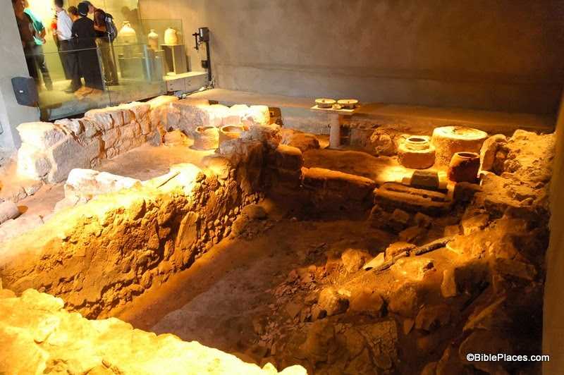
Our obscure site for this week is The Burnt House in the Jewish Quarter of the Old City of Jerusalem. This place is probably familiar to many readers of this blog, but I don’t think it makes it onto the itinerary of many tours to the Holy Land so it qualifies as “obscure.” This is a site that dates back to the destruction of Jerusalem by the Romans in the first century. In his book, The Holy Land, Jerome Murphy-O’Connor introduces the site in this way:

A month after the destruction of the Temple and the Lower City in early September AD 70, the Romans stormed into the Upper City: ‘when they went in numbers into the lanes of the city, with their swords drawn, they slew without mercy those whom they overtook, and set fire to the houses whither the Jews had fled, and burnt every soul in them’ ([Josephus,]  War 6: 403). This was one of those houses. The latest coin found among the charred debris on the floor was dated AD 69; an unused spear stood in one corner.

One thousand, nine hundred years later, archaeologists working under Nahman Avigad uncovered this house that (presumably) had been destroyed by the Romans. What you see in the picture above is the bottom level of the house. Leen Ritmeyer has posted his reconstruction of the entire house on his blog here, along with some newspaper clippings from the time of its discovery. While discussing this site, Avigad once wrote:

This house was destroyed by an intense fire and was filled with fallen stones, wooden beams (carbonized) and layers of ash. The plastered walls were completely covered with soot, and the debris concealed many artefacts. What is unique here is the fact that the debris had not been cleared away or disturbed by later construction: Everything remained just as it was when the building was destroyed.

Many of these artifacts can be seen in the museum which now sits under the buildings of the modern Jewish Quarter. The most chilling aspect of this discovery was the fact that the archaeologists found the skeletal remains of an arm of a young woman, lying on the threshold of the entrance. Presumably this was one of the victims who died at the hands of the Romans in AD 70.

This photo and over 1,500 others (including pictures of the artifacts on display in The Burnt House Museum) are available in Volume 3 of the Pictorial Library of Bible Lands, and can be purchased here for $39 (with free shipping). If you care to visit the site on your next trip, the Burnt House Museum is located at 2 Hakaraim Street, Jerusalem, near the top of the long staircase that leads down to the Western Wall Plaza.

The first excerpt was taken from Jerome Murphy-O’Connor, The Holy Land: An Oxford Archaeological Guide from Earliest Times to 1700, 4th ed. (Oxford: Oxford University Press, 1998), pp. 73-74.  The 5th edition can be purchased here.


The second excerpt was taken from Nahman Avigad, “Excavations in the Jewish Quarter of the Old City, 1969-1971,” p. 46, in Jerusalem Revealed: Archaeology in the Holy City 1968-1974 (Jerusalem: The Israel Exploration Society, 1975).

Share:

(Post by Seth M. Rodriquez)

What is the most significant, ancient harbor city in Israel that hardly ever gets visited by tourists?

Everyone has heard of Caesarea, but that place is a young sprout compared to this site. Acco and Joppa are potential candidates, but even they get more publicity than this site. Continuing our series of “Obscure Sites in the PLBL” (or “What You Missed on Your Trip to the Holy Land”) we focus this week on the small but significant site of Dor.

The map below is from the PowerPoint files included in Volume 2 of the Pictorial Library of Bible Lands. Dor is circled in the top left section of the map.

Tel Dor is located on the small Plain of Dor, which is nestled between Mount Carmel and the Mediterranean Sea. For a description of this small region, you can read a post I wrote on the Wild Olive Shoot blog here. In that post you will learn that this small strip of land in Israel’s central region was more often controlled by foreigners than it was by Israelites. It served as a foothold into the region for Phoenicians and the Sea Peoples. In fact, in ancient times it was easier to get to this region by boat than it was by foot, due to the marshy terrain in the area.

This brings us to the photo itself. Below you can see three boat slips used in ancient times by the inhabitants of Dor. The city was built right next to the sea which made it easy to haul boats in and out of the water. According to the excavators of Tel Dor, “The boat-slips are probably Hellenistic and/or Persian; they may have been dry-docks for fishing vessels, or berths for war-galleys.” (Reference: http://dor.huji.ac.il/areaE.html.) According to the photo annotations included in the PLBL, you won’t find boat slips like this at any other site on the eastern coast of the Mediterranean.

So the next time you’re in Israel, take a little time to explore this small (but significant) site. Archaeological remains from the time of Abraham to the period of the Crusaders have been found here. In addition to the boat slips, you will find the remains of a two-chambered gate from the Iron Age, two temples from the Roman Period, a purple dye factory used from the 1st to 6th centuries AD, a museum where you can see artifacts found in the area, and beautiful harbors where you can take a refreshing dip in the sea.

This photo and over 1,200 others are available in Volume 2 of the Pictorial Library of Bible Lands, which can be purchased here for $39 (with free shipping). Aerial shots of Tel Dor are available here and here on Ferrell Jenkins’s blog, and the Tel Dor excavation team has a very informative website at http://dor.huji.ac.il/. For more information on the region and additional photographs, see my post here.

Share:

(Post by Seth M. Rodriquez)


For the next few posts of our “Picture of the Week” series, we will be working our way back through the Pictorial Library of Bible Lands and focusing on obscure sites included in the collection. One of the great things about the PLBL is that it includes places that you would never typically go when you visit the lands of the Bible. Even if you spent a semester or a whole year in Israel, Jordan, Egypt, Turkey, or one of the other countries covered in the collection, you would probably not visit every site that Todd Bolen and his team of photographers have assembled in the PLBL. So this little sub-series can be called “Obscure Sites in the PLBL.” Or perhaps, “What You Missed on Your Trip to the Holy Land.”

Our first stop is the ancient city of “Kedesh in Galilee in the hill country of Naphtali” (Josh. 20:7). This site is located just west of the Huleh Basin, in the region north of the Sea of Galilee. Below is a section of a map provided in Volume 1 of the PLBL which shows the location of Kedesh.

Tel Kedesh itself can be seen image below, covered with spring wildflowers. In the Old Testament period, this was one of the places designated a “city of refuge” where someone could escape from an avenger if they had accidentally killed someone (Josh. 20:1-9). There were six cities of refuge scattered throughout the Israelite territory and Kedesh was the one that was farthest to the north.

Kedesh also shows up in Judges 4. This was the where Barak lived, and it is where the Israelite army assembled before they marched out to war under the leadership of Deborah and Barak. At the time, the king of Hazor was oppressing the Israelites. Hazor is only about 8 miles southeast of Kedesh, and in the image above the camera is looking in that direction.

Lastly, Kedesh is mentioned in 2 Kings 15:29 where it was conquered by Tiglath-pileser of Assyria, along with many other cities in the region. However, the site continued to be occupied for many centuries after that. In the Roman period a temple was built here, and if you visit the site today you can see part of one wall still standing. Several pictures of the Roman temple at Kedesh are available in Volume 1 of the PLBL.

This image and over 1,100 others (along with the map) are included in Volume 1 of the Pictorial Library of Bible Lands and is available here for $39 with free shipping. Additional photographs taken in this region can be seen here, here, and here on BiblePlaces.com. Historic images of this region can be seen herehere, and here on LifeintheHolyLand.com.

Update: Another suggested location for the Kedesh of Barak is Kh. el-Kidish, southwest of the Sea of Galilee. Both of these sites were within the territory of Naphtali.

Share: