fbpx
(by Chris McKinny)

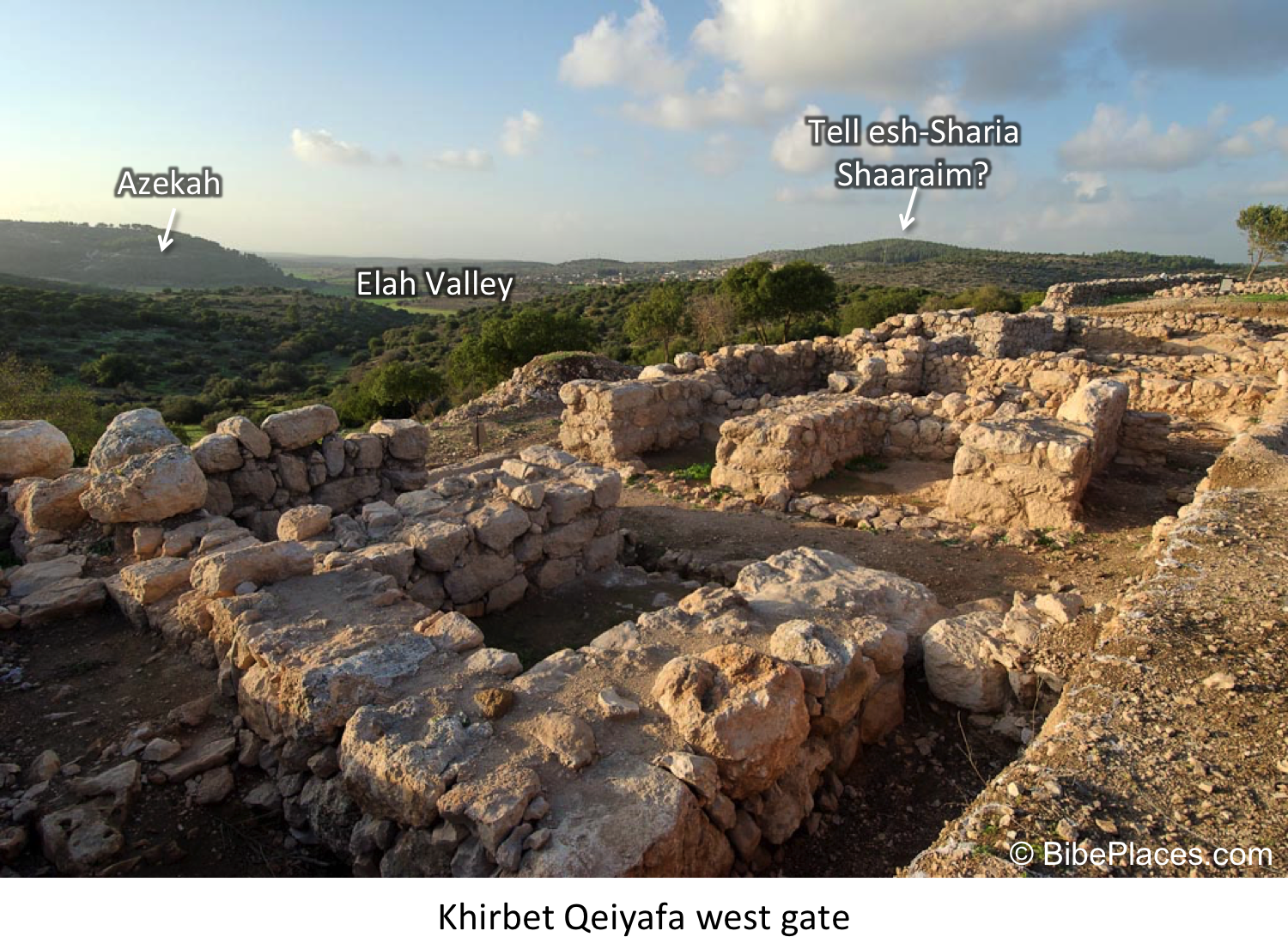
The book of Joshua has the most geographical details of any book in the Bible. This is particularly the case for Joshua 13-21, which provides a series of different lists or non-graphic “maps” describing different aspects of Israel’s tribal settlement. Joshua 12, which precedes this section, is different (and unique) than the subsequent lists in that it provides a detailed list of 34 “slain kings” of Moses and Joshua. In a sense, this list provides a summary of Numbers 21 (the Transjordan Conquest under Moses) and Joshua 5-11 (the campaigns in Cis-Jordan under Joshua) as it lists all of the towns mentioned in these campaigns and provides some additional towns (e.g. Tirzah) that were apparently involved in the conquest.

Interactive Map of Joshua 12

Site Identifications

In this interactive map, I have compiled all of the towns in the list and provided the known archaeological details about the site (see also bibliography below) in a compact form. Wherever possible I have linked a low-resolution photo of the site. Of the 34 towns in the list, 30 can be identified with relative certainty. These four sites include the following: Goiim, which has not been identified; Ai which is probably to be identified in the area of et-Tell, but the conquest site could be located at a nearby site (e.g. Kh. el-Maqatir?); Hormah has not been securely identified, but I suggest Tell Beit Mirsim (McKinny 2015); and Maron/Madon/Meron is possibly Tell el-Khureibeh (e.g. Rainey and Notley 2006:129) just on the Lebanese side of the Israeli-Lebanese border. There are various identification problems with other sites in the list, however, most of these site identifications are generally agreed upon.

Archaeological Analysis

Assuming the traditional connection between Ai and et-Tell and my suggested connection of Hormah with Tell Beit Mirsim, this leaves us with 32 sites that have been identified and surveyed or excavated. Significantly, 28 of these 32 sites have clear Late Bronze Age remains. And what are the sites that are missing Late Bronze? Heshbon (Tell Heshban), Ai (et-Tell?), Arad (Tell Arad), and Makkedah (Khirbet el-Qom). Makkedah was only briefly excavated and Middle Bronze remains were found at the site, which might hint at the presence of later remains. Heshbon revealed phases of the earliest Iron I phases, but not Middle or Late Bronze Age. Ai and Arad are two of the three “etiological” towns along with Jericho (which, in fact, has Late Bronze) whose inclusion in the conquest narratives is usually associated with their large Early or Middle Bronze ruins (i.e. later Israelites attributed the observed ruins to traditional Joshua and Moses figures). This brief post is not the place to argue for or against this rationale, however, in light of the evidence of 88% of the towns in the Joshua 12 list having Late Bronze/Canaanite occupation it seems worth noting that these arguments are based on exceptions to what appears to be a coherent depiction of Late Bronze Canaan. This at least points to the likelihood that the writer of the Joshua 12 list (which, again, reflects the conquest narratives of Josh. 5-11) had a detailed understanding of the geopolitical landscape of Canaan in the Late Bronze Age.


Download Bibliography here.

Share:

Bill Schlegel has released another teaching video based on the Satellite Bible Atlas, this one focused on the northern regions of Israel. The 18-minute video describes the geographical and historical significance of the:

  • Sea of Galilee
  • Golan Heights
  • Huleh Valley
  • Mt. Hermon

Schlegel has taught college and graduate students as a resident professor in the land of Israel for 30 years. His new video series combines his expertise with excellent maps and aerial footage taken with a drone. These videos could serve your own family as well as a small-group Bible study or a school classroom. The series now includes 10 videos. They are all free. If you benefit from them, you might consider commenting on their Facebook page or sharing with your friends.

Share:
(by Chris McKinny)


In past years, this blog has
discussed extensively
the identification of Khirbet Qeiyafa, which has been
identified with Shaaraim by the excavators. I agree that Khirbet Qeiyafa should
not be identified with Shaaraim (see also below), but if Khirbet Qeiyafa is not
Shaaraim then where should we locate the biblical town?
  
Shaaraim is mentioned twice in the
biblical narrative, once in the Eshtaol district (Josh. 15:36, cf. Onom. 87.1) where
it is found between and again in association with the Philistine retreat
following the death of Goliath (1 Sam. 17:52). The text states that they fled
“as far as Gath and up to the gates of Ekron…on the way of Shaaraim, as far as
Gath and Ekron.” This latter context clearly puts the site in the vicinity of
the battle, which occurred in the Elah Valley between “Socoh and Azekah at
Ephes Dammim” (1 Sam. 17:1). Also, it should be noted that this reference does
not actually refer to the town of Shaaraim, but to the road that led to Gath
(Tell es-Safi) and Ekron (Khirbet el-Muqqana). Therefore, the text seems to
indicate that Shaaraim should be located west and perhaps north of the battle
with the toponym likely deriving from the routes that went through the Elah and
Sorek Valleys to Philistine Gath and Ekron (Na’aman
2008b:2–3).


Click on sites to see archaeological details and pictures


Garfinkel and Sanor, the excavators
of the recently concluded excavations at Khirbet Qeiyafa (2012), have revealed
one of the more intriguing ancient sites from the Early Iron Age IIA (i.e. 10th
century BCE). They have identified
Khirbet Qeiyafa with Shaaraim. This argument is based on three main criteria:
1) Shaaraim occurs after Socoh and Azekah in Joshua 15:35-36, 2) the site is
located directly above the presumed location of the biblical battle between
David and Goliath, and 3) the site produced two Iron IIA four-chambered gates
inside of a massive casemate fortification, which gave the name to the site
(Shaaraim = two gates) (Garfinkel and Ganor
2008; Adams 2009:47–66).
This identification has received a good deal of criticism from various scholars
who have offered different identifications for Khirbet Qeiyafa (Na’aman 2008a
  Gob, before changing his mind in,
2012:88; see also Finkelstein and Fantalkin 2012:48; Galil 2009 – Netaim; Levin
2012b –  Ma’agal – interpreted as a
circular military fortress mentioned in 1 Sam. 17:20; Bolen 2012 –  Ephes Dammim, but it is possible that this is a
regional term).
Simply stated, Khirbet Qeiyafa should not be identified with Shaaraim. This is
due to the fact that the dual ending most likely does not mean “two gates” and
the site should be located further to the west/northwest (Na’aman
2008b:3–4; see also Elitzur 2004:282–290). This latter point means that
Rainey’s earlier identification with Khirbet es-Saireh can probably be ruled out on
geographical grounds (see discussion in 1975:69*; but see his later opinion that left Shaaraim unidentified 2006:147). On the other hand, Dagan’s suggestion of Khirbet
esh-Sharia, which is situated between Azekah and Khirbet el-Kheisum
(Adithaim?), would seem to fit this geographical requirement (1996a:139). Additionally, Khirbet
esh-Sharia would seem to present a compelling toponymic connection with
Shaaraim. The archaeological remains at the site are also in line with this
identification, as the site has remains from the Iron IIA (30 dunams**), Iron
IIB-C (40 dunams), and
Roman-Byzantine periods (Zissu
2000:77*–78*; Dagan 2000:site 55).


I disagree with Na’aman’s
conclusion that Khirbet esh-Sharia is not far enough to the west to match the
retreat of the Philistines (1 Sam. 17:52) (2008b:4–5). There are no known Judahite
sites to the west of Azekah (i.e. between Azekah and Philistine Gath) and it
seems that the Azekah-Tell Judeidah ridge formed a clear topographical border
between Philistine Gath and Judah (1983:10–11). Khirbet esh-Sharia sits very
near both the Elah Valley route to Gath and Ekron (Dorsey 1991:J6) and the “Diagonal Route” that
connects the Elah and Sorek Valley systems (Dorsey 1991:Sh2). In light of Na’aman’s
contention that Shaaraim was the “gateway to Judah” (2008b:4–5), it is difficult to
understand his hesitation to identify a site that perfectly suits his
definition.

** 1 Dunam = 1000 square meters

Update: Rainey references updated. 


Bibliography (note links to available online PDFs)

Adams, D.L.
            2009  Between Socoh and Azekah: the Role of the
Elah Valley in Biblical History and the Identification of Khirbet Qeiyafa. In Khirbet
Qeiyafa Vol. 1, Excavation Report 2007–2008
, edited by Y. Garfinkel and S.
Ganor, pp. 47–66. Israel Exploration Socity, Jerusalem.

Bolen, T.
            2012  Pictorial Library of Bible Lands.
BiblePlaces.

Dagan, Y.
            1996  Cities of the Judean Shephelah and Their
Division into Districts Based on Joshua 16. Eretz Israel 25: 136–46,
92*.
            2000  The Settlement in the Judean Shephelah in the
Second and First Millennium BC: A Test Case of Settlement Processes in a
Geographical Region. Unpublished Ph.D. Dissertation, Tel Aviv University, Tel
Aviv.

Dorsey, D.A.
            1991  The Roads and Highways of Ancient Israel.
The Johns Hopkins University, Baltimore and London.

Elitzur, Y.
            2004  Ancient Place Names in the Holy Land:
Preservation and History
. Hebrew University and Magnes Press and
Eisenbrauns, Jerusalem and Winona Lake.

Finkelstein, I., and A. Fantalkin
            2012  Khirbet Qeiyafa: An UnsensationalArchaeological and Historical Interpretation. Tel Aviv 39(1): 38–63.

Galil, G.
            2009  The Hebrew Inscription from Khirbet
Qeiyafa/Neta’im: script, language, literature and history. Ugarit-Forschungen(41):
193–242.

Garfinkel, Y., and S. Ganor
            2008  Khirbet Qeiyafa: Sha`arayimn. Journal of
Hebrew Scriptures
8(0).

Levin, Y.
            2012  The Identification of Khirbet Qeiyafa: A NewSuggestion. Bulletin of the American Schools of Oriental Research(367):
73–86.

Na’aman, N.
            2008a  In Search of the Ancient Name of KhirbetQeiyafa. Journal of Hebrew Scriptures 8(21): 2–8.
            2008b  Shaaraim – The Gateway To The Kingdom OfJudah. Journal of Hebrew Scriptures 8: 2–5.
            2012  Khirbet Qeiyafa and the Philistine- Canaanite
Struggle in South Canaan in the Early Iron Age. Cathedra 143: 65–92.
Rainey, A.F.
           1975  The Identification of Philistine Gath. A Problem in Source Analysis for Historical Geography. Eretz Israel 12: 63*–76*.           
           1983  The Biblical Shephelah of Judah. Bulletin
of the American Schools of Oriental Research
(251): 1–22.

Zissu, B.
            2000  Khirbet esh-Shari’a. Hadashot
Arkheologiyot: Excavations and Surveys in Israel
111: 77*–78*.
Share:
(by Chris McKinny)

Barrington Atlas of the Greek and Roman World  (edited by Richard J. Talbert) is not a new publication—in fact, it has been in print for fifteen years. The print version has been heralded as one of the best and most exhaustive atlases of the Greek and Roman World. Here are a couple summary reviews of the print version.

“This atlas is an indispensable tool for historians concerned with ancient times. But it is also a source of great pleasure for the amateur, the lover of literature.”—Bernard Knox, Los Angeles Times Book Review 

“Beautifully produced with an exquisite combination of scholarly precision and the highest level of cartographic art, this atlas is one of the greatest achievements in 20th-century Greek and Roman scholarship—and it probably will never be superseded.”—Publishers Weekly

It took twelve years and dozens of contributors to complete its 102 maps. In terms of historical periods, the atlas covers from c. 1000 BCE–640 CE (Archaic-Late Antique/in the Levant Iron Age II–Byzantine Period)—these periods are marked on the various maps with color-coded highlighting beneath the ancient sites. The maps only include ancient site names and regions, but do not include markings for historical events. This is both an advantage and limitation of the atlas, as is noted in the introduction by the editor. The advantage is that a scholar may supply their own markings for historical reconstruction—the limitation is that the lay person, in most cases, is not familiar with the historical events.

The print version of the Barrington Atlas is clearly a valuable reference work, as has been recognized for the last fifteen years. However, it is hampered by its price ($425 for the atlas only!) and its cumbersome size. On these two points the iPad version takes a great leap forward in improving the Barrington Atlas.

Details for Digital Version:
Platform: iPad app (not in iBook library)
Cost: $19.99
Size: 411 MB

I observed three main advantages of the iPad app over the print version:

  1. Versatility. A reference tool’s usefulness is often heightened by digital access, as it enables a user to carry many large-sized works within a computer, tablet or smartphone. This advantage is particularly pronounced with regards to the Barrington Atlas due to the sheer physical size of the printed version.
  2. Navigation. The iPad version functions very similar to an image database in that the maps may be accessed from a host of different locations in the app including a simple search in the “locator” tab or the hyper-linked gazetteer. The drop-down key menu is a very nice feature that reduces clutter on the maps.
  3. Price. $19.99 on iPad versus $425 for printed atlas and $285 for printed map-by-map directory. That is $670 for a non-interactive three-volume work that takes up real estate in your library or $20 for the same data with intuitive interactive navigation tools and search functions. Need I say more.

Limitations:

  1. In some cases another level of resolution on the maps (for zooming) would be helpful, however, this would also increase the file size, which is already at 411 MB (a substantial amount for a 16GB baseline iPad).   
  2. It would be helpful if the atlas was available for use on a desktop or laptop as well as iPad. The iBooks store used to be only available to iPad users, but is now a multi-platform offering for iPhone, iPad, MacBooks and iMacs. This would enable users to have access to the Barrington Atlas alongside a word processor and/or other reference works (e.g. Logos, Accordance, etc.) Users would be more likely to download large files on laptops and/or desktop computers and they would also have better access to the maps for use in presentations. 

    Comparison to Other Atlases:

    Readers of this blog will probably be acquainted with several different atlases of the biblical world, such as the ESV, Zondervan, Moody, Carta, and Sacred Bridge Bible atlases. It should be understood that the Barrington Atlas of the Greek and Roman World is directed at a much broader area and subject material than these atlases. For the price, functionality, and large quantity of maps it is hard to beat the Barrington Atlas of the Greek and Roman World. Still, potential users of this atlas may also be interested in the following works:

    1. Michael Avi-Yonah – Gazetteer of Roman Palestine (1976)
    2. Carta’s Translation of Eusebius’ Onomasticon  (with site index) (2003), also available on Accordance which I would highly recommend over the print version due to its search capabilities.
    3. Yoram Tsafrir, Leah de Segni, Judith Green – Tabula Imperii Romani Iudaea Palaestina (1994)

    These works deal with the same periods (Hellenistic-Byzantine), but they provide much more detailed discussions and maps related to the historical geography of Greco-Roman Judea, Samaria, Galilee (i.e., Palestine). These regions are covered in part 5 of the Barrington Atlas “Syria-Meroe” — specific maps 68–71. These maps are well designed and accurate, but limited in the amount of place names that they display.

    In sum, while noting the limitations that I discuss above, I would definitely recommend this atlas for anyone interested in the Greco-Roman world… assuming that you own an iPad.

    Share:

    Bill Schlegel, author of the Satellite Bible Atlas, has just posted a video showing the ascent to Jerusalem from the Shephelah. The 6-minute video uses drone footage to show the modern highway’s route and the new construction. In antiquity, travelers followed the natural routes along the ridges.

    Today when we deviate from those ridges, we spend billions to destroy the landscape in the construction of passes, bridges, and tunnels.

    For best viewing, change the settings to HD, Full Screen.
    Share:

    Those who studied at the Institute of Holy Land Studies (today Jerusalem University College) or otherwise used the venerable Student Map Manual (SMM) may be interested to know that marking instructions for sections 10, 11, 12, 13 exist. http://ecx.images-amazon.com/images/I/51jIvM97ASL._SL500_SY344_BO1,204,203,200_.jpgThough I used the SMM in the classroom for 11 years (until nary a one was to be bought, borrowed, or stolen), I was unaware that someone had written a sequel to the marking instructions of
    James Monson’s The Land Between. Monson’s work only covered the Old Testament periods (through section 9 which ended with the 586 BC destruction of Jerusalem).

    In 1992 Frank L. Benz of Wartburg Theological Seminary in Dubuque, Iowa, self-published Holy Land History: A Study Guide to Palestine from the Persian to the Byzantine Periods. This 134-page work follows the marking scheme developed by Monson and proceeds in chronological order. In his acknowledgments, Benz cites his students who asked him, “When will the instructions for the rest of the Manual be prepared so that we can finish the course?” I can only wonder why I never knew of this work, particularly when I was doing graduate work at the Institute from 1992 to 1994.

    For those interested, I have scanned the preliminary material of the work including the preface and table of contents. Since the SMM is now difficult to find, this post is more of a historical note than anything else. Those who already own a copy might enjoy reading through Benz’s marking instructions, though I don’t have any advice to give on where such is to be found. (No matches are currently returned at addall.com.)

    There are several worthy successors to the SMM and its marking guides for all current and future students of the historical geography of the Bible. I would highlight two resources in particular.

    James Monson continues to develop fantastic study resources at Biblical Backgrounds, Inc. His Introductory Study Package includes Regions on the Run and a set of 7 beautiful, large-format maps.

    Bill Schlegel recently published the Satellite Bible Atlas. This work is similar in style to the SMM, though the markings are printed on the maps, saving the student a lot of time. The atlas comes with two commentaries. The briefer of these is printed on facing pages of the atlas, making it convenient and ideal for beginning studies. (I am requiring it of all of my OT and NT Survey students at The Master’s College.) The long commentary is valuable for more eager students and is available for free. Both commentaries cover the Intertestamental and New Testament periods.

    Share: