fbpx

The February 2014 issue of the BiblePlaces Newsletter was sent yesterday (you can read it here, or sign up for future newsletters here). After it went out, A.D. Riddle alerted me to the availability of three of the missing volumes of the Survey of Western Palestine, now online for free. We’ve now updated that article to include all of the available volumes. If you simply want to access the volumes we just added to the list, you can do that with these links: Special Papers on Topography, Archaeology, Manners and Customs, etc. (1881), by C. Wilson, C. Warren, C. R. Conder, et al. (pdf) The Survey of Western Palestine: Memoir on the Physical Geology and Geography of Arabia Petraea (1886), by E. H. Hull (pdf) Survey of Eastern Palestine: Topography, Orography, Hydrography and Archaeology: The Adwan Country (1889), by C. R. Conder (pdf) We’ve also updated the single file download of all 10 available volumes in pdf format. If you want the maps to go along with them, you can get high-quality scans along with a number of other valuable features in our collection here ($35). http://www.bibleplaces.com/images/hv/swp500.jpg

Share:

David Dorsey, longtime professor of Old Testament at Evangelical Seminary in Myerstown, Pennsylvania, died last week. The local newspaper carries his obituary and the seminary website provides his faculty profile. Carl Rasmussen shares some personal reminiscences on his blog.

The first I heard of Dr. Dorsey was in a class with Anson Rainey. He described one of his students who purchased a motorcycle so he could drive throughout the country, studying the sites and roads.

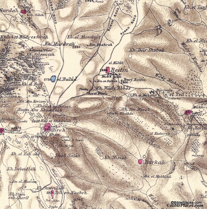
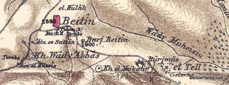
One result of his dedication was the discovery of biblical Makkedah, location of the cave where five Canaanite kings hid from Joshua (Josh 10:16).

1 View of Kh el Qom from W--view E, with caves on left dd
Makkedah of Joshua 10.
Photo by David Dorsey.

This research led to Dr. Dorsey’s dissertation on The Roads and Highways of Ancient Israel, published by Johns Hopkins in 1991. This work is the standard reference on the subject and I’ve benefited it from it in numerous ways. One of my dissertation readers had little to say in one of his passes through my early chapters, but of all the works he could have chastised me for neglecting, the one he chose was Dorsey’s book. While all who knew Dr. Dorsey could testify to the impact that Israel had on his life, Dr. Dorsey forever left his mark on historical geography of ancient Israel through this book.

Another way that Dr. Dorsey changed lives was through his trips to Israel. His passion brought many to Israel and some caught the bug and returned. One of those became a close friend to my wife and me more than 20 years ago and she served our students at IBEX for more than 10 years. Without Dr. Dorsey’s vision and work, many hundreds would have missed out from just this one relationship.

On a family vacation several years ago, I asked Dr. Dorsey if we might visit with him. He and his wife Jan provided the warmest possible welcome and while our kids swam in the backyard, they shared with us their lives, treasures, and dreams. It was a splendid day and I left with the desire to imitate Dr. Dorsey’s gracious spirit.

Several things remained. Dr. Dorsey had been long at work on a two-volume project on every law in the Old Testament from a Christian perspective. For years I have prayed weekly that the Lord would sustain his health to complete this project. Dr. Dorsey also had an extensive collection of photos from his motorcycle years, and while I included a handful in the recent edition of the Pictorial Library of Bible Lands, I wanted to reserve most of these for a separate collection in the future.

To many, Dr. Dorsey has been a model Old Testament scholar, an inspiring teacher in the classroom, and a faithful man of God. His departure is a tremendous loss.

Narrow Jabneel valley and cows (I was charged by bull!) dd
Jabneel Valley.
Photo by David Dorsey.
Share:

We announced this in the latest BiblePlaces Newsletter, but if you missed that, you may want to know that a new edition of the Satellite Bible Atlas is available. The hardcover edition is more durable and lays flat, making it ideal for study at home and on the field. For only $28, this is an affordable investment for all who love the Bible. Here are a few reasons why:

1. Every map covers a full page and is in full color. That allows for lots of detail and context.

3. The atlas provides maps of everything from Abraham’s journey from Ur to Paul’s arrival in Rome. Whatever you’re reading or teaching, you will find a map that marks the location and explains the event. You’ll never have to guess where something took place.

7. Purchase includes free access to all of the maps in digital (jpg) format. This makes it easy to use the maps in the classroom and on location.

You can see the full list of why I think this new atlas by Bill Schlegel is a fantastic resource here.

A wall/door map is also available for $7, but if you buy it together with the atlas, the cost is only $4.

If you’re like us, you always wonder what surprise you’ll find when you go to checkout and learn the shipping cost. For those in the U.S., shipping is free. (And for those not in the U.S., the shipping is outrageous, but that’s beyond our control. There is an Israeli distributor who can ship to some countries less expensively.)

We encourage you to consider this as a gift for a parent, child, pastor, teacher, or friend. This is a unique resource at a terrific price.

Share:

There is a fabulous new resource available that I’m delighted to be the first to tell you about. For the last four years when teaching seminary and church groups in Israel, I’ve had as the class guide an outstanding resource that nobody else could buy. I joked with my last group that this book cost $3,640 because they could only get it by coming with me on the trip. The other option was to enroll as a student in one of the short- or long-term study programs at The Master’s College’s campus in Israel for even more money.sba500 Today, for the first time ever, you can purchase your own copy of the Satellite Bible Atlas. This new work by Bill Schlegel replaces the venerable Student Map Manual but is superior to it in many ways. One obvious advantage is that you don’t have to spend 60+ hours marking it before it is usable! All the historical markings are printed in bright colors on top of satellite map imagery. Another advantage is that the commentary is on facing pages with the maps, so you have easy access to everything that is going on. If you want more, you can download the free, 200-page expanded commentary, The Land and the Bible: A Historical Geographical Companion to the Satellite Bible Atlas. This resource is ready for personal use, classroom use, and field trip use. The author, Bill Schlegel, has been teaching college and seminary students in Israel for 25 years. Everything in the Satellite Bible Atlas is field-tested by a professor who knows God’s land and loves God’s Word. Here are 7 more reasons I love the Satellite Bible Atlas: 1. The maps are full-size, full color, and full of rich detail of the hills, wadis, plains, and passes. 4.6-Gideon 2. There are 85 maps which means that every major historical event is covered, from Abraham to Paul. Too often the New Testament gets short-changed in atlases, but not here: the Satellite Bible Atlas has 9 maps for the life of Christ and 6 for the apostolic period. 3. The Satellite Bible Atlas includes 17 detailed topographical maps without historical markings. These are ideal for getting the best view of the terrain as well as both ancient and modern sites. 4. I fully trust the markings and the commentary. There are not many works in this field for which I can say that. 5. The north-orientation of the maps means there is no immediate learning curve as there was with the previous atlas we used which put east at the top. I put this atlas in the hands of my church group last year and they were immediately off and running. Several have commented to me in the last few weeks that they regularly use the Satellite Bible Atlas as they read the Bible. 6. The atlas comes with a free copy of all the maps in digital (jpg) format. You will receive a link to download the maps with your order confirmation. 7. For $30, plus $3 shipping and tax where applicable, you get an excellent atlas at an outstanding price. (For an additional discount on purchases of 10 or more copies, contact us.) Check out the sample maps, the table of contents, endorsements, teaching videos, and the free downloads. You can order here.

Share:

(Post by Seth M. Rodriquez)

Having worked through the revised and expanded edition of the Pictorial Library of Bible Lands in this series, we will begin highlighting pictures in a lesser known (but extremely fascinating) series called Historic Views of the Holy Land.  This is a sister collection to the PLBL and is featured in a website called LifeInTheHolyLand.com.

Here is a brief description of the series from the website:


The Historic Views of the Holy Land series is an extensive collection of thousands of photographs, drawings, and maps of the biblical lands from the 19th and 20th centuries.   


The collection, upon which this website is based, features  

  • the most detailed and accurate maps of Palestine made before the birth of the state of Israel  
  • pictures from award-winning photographers who traveled through Egypt, Palestine, Lebanon, Syria, Turkey, and Greece in the 19th century  
  • photographs and drawings which illustrate biblical scenes, including Psalm 23, the Good Samaritan, and the Woman at the Well.

The first bullet point relates to our “Picture of the Week.”  These are the maps created by the Palestine Exploration Fund in the 1870s and published as the Survey of Western Palestine.  The maps contain an amazing amount of detail, were the most accurate maps produced in its day, and were created before the massive political and cultural changes were made in the country during the 20th century.  Produced at a scale of 1 inch to 1 mile, these maps are a treasure trove for students and scholars interested in biblical geography.  A full explanation of the maps and their value can be found here.

Our picture this week focuses on one small area of the maps: the region of Bethel and Ai.

This section shows Beitin as a pink oval in the upper center of the map, which is usually identified as Bethel. It also shows et Tell in the right center and Khirbet el Mukatir to the east of et Tell.  The city of Ai (Gen. 12:8; Josh. 7:2) is identified by many scholars as et Tell, but the Associates for Biblical Research have been conducting excavations at Khirbet el Mukatir over the last couple of decades to investigate the possibility of identifying that site as Ai instead.  Below is an enlargement of the section of the map that shows Beitin, Kh. el Mukatir, and et Tell so that you can see the relationship between the three sites (click on the picture for a higher resolution):

This is just one example of the many uses of the Survey of Western Palestine Maps.  The originals of these maps are not easily accessible in libraries, but the electronic versions are available to all through the Historic Views of the Holy Land collection.

Further information and other images of the Survey of Western Palestine Maps can be found here.  You can download the index to the maps for free here, and you can purchase the maps by visiting here.  For another example of how these maps can be used, see my post on the Wild Olive Shoot blog here.

Share:

Wayne Stiles in the Jerusalem Post:

Studying historical geography, in my own experience, has permanently marked my life and changed the way I understand the Bible. Places and names, which I used to pass over, now immediately bring to mind a site’s history, its geographical pros and cons, its scenery, and even its smells. Having knowledge of a passage’s geography gives me a head start as I attempt to understand why events took place—sometimes repeatedly—in certain locations.
Walking the land of Israel has provided me with a deeper appreciation of God as Lord of world history and of seemingly minor details—both of which bring comfort to my life.
My experience is not unique. I have conducted and videotaped a number of interviews with those who have both studied geography and also been to Israel. Their testimonies illustrate the importance of understanding and experiencing historical geography—not just from a knowledge-based perspective but also as it benefits one’s spiritual life.
My research revealed that those who understand and experience historical geography enjoy a sharper comprehension of the Bible, a clearer direction to its application, and a more effective communication of truth. The study of historical geography provides a greater confidence in the Bible as God’s Word and instills a greater love for the God of the Bible. Those who study geography, coupled with time in the land, experience an even greater benefit than those who simply read books.

Read the whole thing. The research to which Stiles refers is available here.

Judean hills near Guvrin Valley, tb030407741

The hills of Judah near the Guvrin Valley
Share: