fbpx

2 Kings 3

Moab's Rebellion

Standing Stones

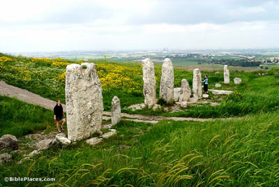
And he did evil in the sight of Yahweh, though not like his father and mother, for he put away the pillar of Baal that his father had made (2 Kings 3:2).

The word “pillar” (Heb. matsebah) is usually considered to be an unhewn stone set up as a memorial or to honor a deity. The location of the pillar taken down by Jehoram is not given; one might expect it to have been in Samaria itself, or perhaps at one of the major cult centers like Dan or Bethel (cf. 1 Kgs 12:28-29). The massive standing stones in this photo are from an earlier period but illustrate the kind of object that is likely to have been taken down by Jehoram.

Mesha Stele

Now Mesha king of Moab was a sheep breeder (2 Kings 3:4).

The Mesha Stele is the most significant Moabite inscription ever discovered. It records the rebellion of Moab’s king Mesha against the Israelite kingdom shortly after the death of Ahab. Ahab’s son Joram responded with the invasion described this chapter, but he was less successful than his father or grandfather, for Mesha threw off the annual tribute and established Moab’s independence in their traditional territory (from the Arnon Valley to the edge of the Medeba Plateau) and expanded into the Medeba Plateau. The inscription describes at length Mesha’s achievements in the decades to follow, including his construction of cities, four temples, and a major road across the Arnon Valley.

The Way of the Wilderness of Edom

“Which way shall we go up?” And he answered, “The way of the wilderness of Edom” (2 Kings 3:8).

The exact route referred to here as the “way of the wilderness of Edom” that the three-king coalition (Israel-Judah-Edom) took is not clear. This photo shows the shallow southern end of the Dead Sea that would have been skirted by the Israelites. The faint outline of the Wadi Numeira is visible across the valley. This may have been the route eventually taken by the Israelites as they made their way toward Kir-hareseth (Kerak).

The Valley

And he said, “Thus says Yahweh, ‘Make this valley full of trenches’” (2 Kings 3:16).

The precise location of this event is not specified. The fact that the Edomite forces have already joined the forces of Israel and Judah may indicate that the Israelite forces had already crossed the Arabah and were somewhere in southern Moab. One possibility could be the Zered River valley, which formed the southern border of Moab and the northern border of Edom. The Zered Valley is about 35 miles (55 km) long and 3.5–4 miles (5.5–6.5 km) wide and drains into the Dead Sea near the southeastern corner. As this photo shows, the region is quite arid most of the year. If it was not the Zered Valley, it would have been valley that looked not very different than this one.

Child Sacrifice

Then he took his oldest son . . . and offered him as a burnt sacrifice on the wall (2 Kings 3:27).

This photo from the Karnak Temple in Luxor shows the city of Ashkelon (in relief) and a possible Canaanite child sacrifice (notice the priest with the incense burner), which was being attacked by Pharaoh Merneptah. This relief may be one of the only illustrations of ancient Near Eastern child sacrifice during the besieging of a city.

Purchase the Collection:

2 Kings (Photo Companion to the Bible)

FREE Shipping plus Immediate Download