fbpx

1 Samuel 10

The Anointed Saul's Travels

Grave Markings

You will find two men close to Rachel’s tomb in the territory of Benjamin at Zelzah (10:2).

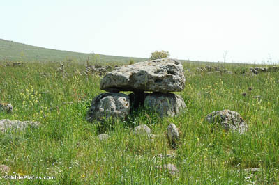
According to Genesis 35:20, Jacob set up a pillar over the tomb of Rachel, which at the time of writing was still there. The use of massive stones to mark special places already had a long history in that day. The pile of very large stones shown here, known as a dolmen, is thought to mark a grave as well, although probably from an earlier time.

Geba

After that you will come to Gibeath-elohim, where the garrison of the Philistines is (10:5).

“Gibeath-elohim” (or “the hill of God”) is probably to be identified with Geba, as this appears to be the same location as the Philistine garrison in 1 Samuel 13:3. It is located east of Ramah about 1.5 miles (2.4 km). Geba was in Benjamite territory but was one of the cities allotted to the Levites (Josh 18:24; 21:17). Geba has been identified with the village of Jaba, which remains inhabited until today. Pottery from the Iron Age I–II (1200–586 BC) was discovered during surveys of the site.

The Way of Zeboim

And you will go down before me to Gilgal (10:8).

The most direct route from Geba to the area of Jericho and Gilgal was the Way of Zeboim/Way of the Wilderness, which connects the region of the Jericho oasis with the middle of the Central Benjamin Plateau. Today this region is inaccessible because of a lack of roads and military restrictions, so the best view is from the air.

Mizpah

Then Samuel called the people together to Yahweh at Mizpah (10:17).

Mizpah had previously been the gathering place of Samuel and the Israelites when they “put away the Baalim and the Ashtaroth, and served Yahweh only” (1 Sam 7:4-5). It is possible, although by no means certain, that the tabernacle was located at Mizpah at that time, having been spirited away from Shiloh before its destruction by the Philistines after the battle of Aphek (Jer 7:12; cf. Ps 78:60-61). Mizpah was also the location of the first phase of the battle with the Philistines (1 Sam 7:10-11).

Gibeah

And Saul also went to his house in Gibeah (10:26).

The large mound visible in this photo of Gibeah was determined by archaeologists to be remnants of the fortress built by Saul. The site was excavated by William F. Albright in 1922–23. This American Colony photograph was taken in 1931. The walls of the remaining tower of Saul’s fortress were still preserved to a height of 6-7 feet (1.8–2.1 m). Atop that was the later Israelite fortress. These ruins have since been destroyed or covered by later construction.

Photo Companion to 1 Samuel

Purchase the Collection:

1 Samuel (Photo Companion to the Bible)

FREE Shipping plus Immediate Download