Aswan was the southern border of pharaonic Egypt. Here the desert reaches the banks of the river. The Nile River Valley begins to the north of Aswan, as at this point the hard sandstone was difficult to cut through. At some points, granite was exposed just beneath the surface of the sandstone. Granite is a very hard rock and even a river like the Nile can only cut through it very slowly.
Aswan
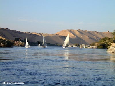
Nile River
Cataracts
Where granite is exposed, rapids, or cataracts, form. Along the Nile, there are 10 cataracts in total. The First Cataract, 7 miles (11 km) in length, is just to the south of Aswan today, and it logically formed the southern border of Egypt. A person traveling along the river by boat would have to leave the river at this point and carry the boat across the desert since it was not passable on the rapids.
Nilometer
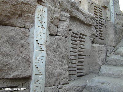
There were many Nilometers in Egypt, but the most important ones were at Elephantine Island. The Nilometer was important as it measured the rise of the floodwaters of the Nile. If the Nile did not rise enough, the land would experience famine conditions. If the Nile rose too high, it would flood and destroy the villages. In three periods, the Nilometers were restored: pharaonic, Roman, Muhammad Ali. Every temple in Egypt had a Nilometer because it was a symbol of life.
Unfinished Obelisk
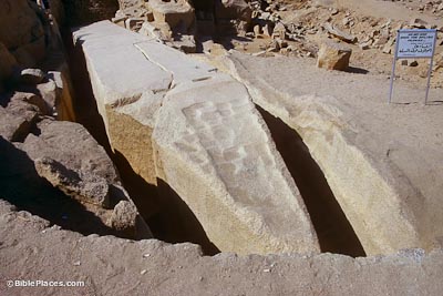
The only granite quarry in Egypt is in Aswan. The closer to the Nile River, the easier it was to float the stones downstream (to Karnak/Luxor and Memphis/Cairo). This is the largest obelisk discovered, but it was never finished for unknown reasons. Had it been completed, the weight of this obelisk is estimated to be at 1200 tons (the next largest obelisk weighs 300 tons). In order to transport the obelisks, four boats were strapped together, and three obelisks were laid crosswise. The Egyptians then waited for the flooding waters to carry the boats away. Hatshepsut recorded that work on one of her obelisks took 7 months.
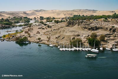
Elephantine Island
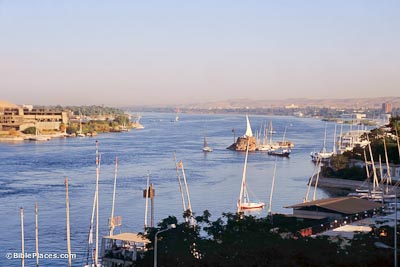
Elephantine Island was famous as a trading capital. Its name comes from the ivory trade with Nubia to the south.
The island was also a frontier post for guarding the southern border of Egypt. Typically this island housed a strong fortress for the army. In antiquity, a bridge connected Elephantine Island with the east bank. Archaeologists have found continuous inhabitation of this island since the time of the Middle Kingdom. One collection of papyri discovered here is from a colony of Jews living on the island in the 5th century BC. These documents include copies of letters sent to Jerusalem asking for help in the restoration of their temple.
Modern City
The city of Aswan today is small and relatively unimportant. Tourists are a major source of income. Another point of interest near the town is the High Dam. Completed in 1971 by President Nasser, the dam has stopped the annual inundation of the Nile River. The dam regulates the flow of water down the river to prevent flooding and it supplies Egypt with most of its electricity. In advance of the construction of the dam, many historical sites were relocated, including the temples of Abu Simbel.

Download all of our Egypt photos!
$34.00 $49.99 FREE SHIPPING
Related Websites
Near Aswan is Philae Island, “relocated” following the construction of the High Dam. For historical images of Philae Island and Elephantine Island, see Life in the Holy Land.
Aswan (Britannica) An encyclopedia article that serves as introduction to the site, with a focus on modern history.
Aswan (Egypt’s Ministry of Tourism and Antiquities) This website, maintained by the Egyptian government, includes a map and a brief history.
Aswan (University of Memphis) Brief description of four monuments near Aswan with photos.
Aswan – Kom Ombo Archaeological Project (official page) The official site about the excavations in this area.
Archaeologists Find Bust of Roman Emperor in Egypt Dig in Aswan (Arab News) This brief article includes one photo to show the find.
Ruins of Ancient Church and Temple Discovered in Egypt (LiveScience) This 2021 article includes several illustrations of what has been found, including a Coptic church.
The Ingenious Nilometer (The Archaeologist) A little more history about Nilometers.
Elephantine Island (Encounters Travel) The page gives quite a comprehensive history on the island, and includes a few photos.
Tombs of the Nobles (Atlas Obscura) Gives a short introduction to this site, and is well-illustrated.
The Tombs of the Nobles (Luxor & Aswan Travel) Includes some helpful travel information for those looking to visit.