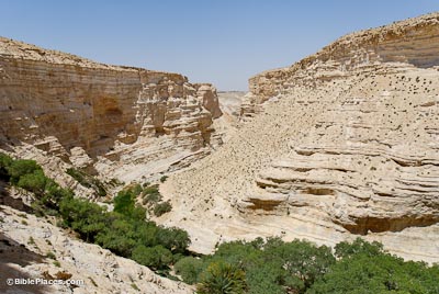
The Nahal Zin is 75 miles (120 km) long and drains 600 square miles (1550 sq km). It is the largest wadi that begins in the Negev. The Nahal Zin was created by reverse erosion as the great height difference between the Negev Highlands and the Jordan Rift caused the underlayers to erode during the rainy season, resulting in the collapse of the harder strata of rock above. The landscape is mostly Eocene limestone, consisting of some brown-black layers of low-grade flint. The flint slows down the erosion of the limestone.
Nahal Zin, Ein Avdat
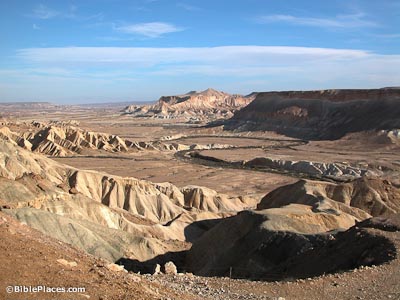
Nahal Zin
Southern Border
The Nahal Zin was the southern border of the land of Canaan that was promised to the Israelites. Numbers 34:3-4 (KJV): “Then your south quarter shall be from the wilderness of Zin along by the coast of Edom, and your south border shall be the outmost coast of the salt sea eastward: And your border shall turn from the south to the ascent of Akrabbim, and pass on to Zin: and the going forth thereof shall be from the south to Kadeshbarnea, and shall go on to Hazaraddar, and pass on to Azmon.”
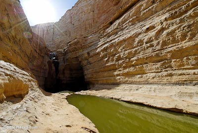
Springs
Ein Avdat emerges at the base of the 50 foot (15 m) waterfall. This spring water is a bit salty, but the plants around the pool can survive on saltwater. The springs in this canyon are a geological puzzle. To this day, scholars don’t know where they come from. This is a dry region and during rainfall, the runoff doesn’t penetrate the ground but drains off in the wadis. The current theory is that the springs come from flash flood water that seeps down through the stream bed gravel and thus into the ground below.
Monks' Dwellings
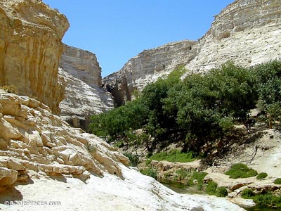
Some caves carved into the chalky limestone cliffs of Nahal Zin were apparently used in the 6th century AD by monks from nearby Avdat. These monks sculpted out closets, shelves, benches, stairs, and water systems. A Greek inscription was found in one of the caves. It is a prayer to St. Theodorus, a monk whose name is also found in a monastery in Avdat. At the top of the canyon are the remains of a Roman fortress.
Download all of our Negev and the Wilderness photos!
$34.00 $49.99 FREE SHIPPING
Related Websites
For historical images of monks, see Life in the Holy Land. For a Bible chapter related to Nahal Zin, see Joshua 15.
Ein Avdat (Jewish Virtual Library) An informative article that provides many details on the geography and history of the area, plus helpful facts about the national park.
Nahal Zin and Avdat—A Biblical Border with a View (Wayne Stiles) A short introduction to the site with lots of useful illustrations. Includes a Google street view and a introductory video. See also Stiles’ article titled “The Wilderness of Zin – Inspiring Awe but Not Obedience to God” (focusing more on the Machtesh Ramon).
Insights into Nahal Zin (Institut fur Hydrologie) An interactive map of Nahal Zin with numerous links to photographs of certain areas.
A Traveler’s Guide to Ein Avdat National Park (Laidback Trip) This article includes a few photos, many internal links, and all the needed information for visiting the site.
Ein Avdat (Hiking the Holyland) The record of one hiker’s experience, with some wonderful photos.